Torrance, California facts for kids
Quick facts for kids
Torrance, California
|
|||||
|---|---|---|---|---|---|
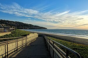
Torrance Beach
|
|||||
|
|||||
| Motto(s):
"A Balanced City"
|
|||||
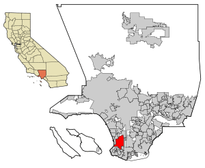
Location of Torrance in the County of Los Angeles
|
|||||
| Country | United States | ||||
| State | California | ||||
| County | Los Angeles | ||||
| Incorporated | May 12, 1921 | ||||
| Named for | Jared Sidney Torrance | ||||
| Government | |||||
| • Type | Council-manager | ||||
| Area | |||||
| • Total | 20.53 sq mi (53.18 km2) | ||||
| • Land | 20.50 sq mi (53.10 km2) | ||||
| • Water | 0.03 sq mi (0.08 km2) 0.37% | ||||
| Elevation | 89 ft (27 m) | ||||
| Population
(2020)
|
|||||
| • Total | 147,067 | ||||
| • Rank | 8th in Los Angeles County 41st in California 198th in the United States |
||||
| • Density | 7,163.5/sq mi (2,765.46/km2) | ||||
| Time zone | UTC−8 (Pacific) | ||||
| • Summer (DST) | UTC−7 (PDT) | ||||
| ZIP Codes |
90277, 90278, 90248, 90501, 90503–90510
|
||||
| Area codes | 310/424 | ||||
| FIPS code | 06-80000 | ||||
| GNIS feature IDs | 1652802, 2412087 | ||||
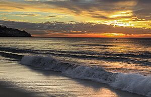
Torrance is a city located right on the coast in Los Angeles County, California, United States. It's part of the "South Bay" area of Los Angeles. A small part of the city, about 1.5 miles (2.4 km), touches the Pacific Ocean. Torrance has nice weather all year, with about 12 inches (300 mm) of rain each year. The city was officially started in 1921. In 2020, about 147,067 people lived there. Torrance has a beautiful beach and 30 parks. It's also where the American Youth Soccer Organization (AYSO) began.
Contents
The Story of Torrance
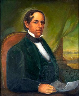
Ancient Times: The Tongva People
For thousands of years, the area where Torrance is now was home to the Tongva Native Americans. Much of this land, including the modern South Bay, used to be large wetlands.
Spanish and Mexican Rule
In 1784, the Spanish King gave a huge area of land called Rancho San Pedro to a soldier named Juan José Domínguez. This land included what is now Torrance. Later, in 1846, the land was divided. Governor Pío Pico gave part of it, called Rancho de los Palos Verdes, to José Loreto and Juan Capistrano Sepulveda. This happened when California was part of independent Mexico.
How Modern Torrance Began
In the early 1900s, a real estate developer named Jared Sidney Torrance and other investors saw a great idea. They wanted to create a community south of Los Angeles that had both factories and homes. They bought land from an old Spanish grant. Then, they hired a landscape architect, Frederick Law Olmsted Jr., to design the new town.
The town was founded in October 1912 and named after Jared Torrance. The city of Torrance officially became a city in May 1921. The first homes were built on Gramercy and Andreo avenues. Many of these houses turned 100 years old in 2012. This older part of Torrance is now being considered a historical district. Some of the first buildings were designed by Irving Gill, a famous architect known for his unique style.
The Historic Olmsted Design
Torrance was planned to be a new kind of city. It was based on the "Garden City Movement," which aimed for a good balance between industry and living spaces. The original design by the Olmsted Brothers had 109 city blocks. These were split into three areas: homes, businesses, and factories.
A special feature of the plan was the downtown business area. It was designed to line up with a view of Mount San Antonio in the San Gabriel Mountains. This downtown area, now called Old Torrance, was built on a diagonal. This helped ocean breezes keep the air clean from factory pollution for the homes and shops. The industrial parts of the city were placed on the eastern side.
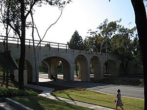
Public transportation was very important when Torrance was founded. The Pacific Electric Red Car train connected downtown Los Angeles to the new downtown Torrance. The train station, designed by Irving Gill in 1912, had a Spanish revival style. In May 1913, the Pacific Electric Railroad Bridge was built. This bridge, also called the "El Prado Bridge," helped expand the industrial area. It was used to transport goods and workers to Torrance factories. The Red Car line ran under the bridge to the train station.
The bridge no longer carries trains, as the Red Car line closed in the 1940s. On July 13, 1989, the bridge became the city's second entry in the National Register of Historic Places. It is now a symbol used in the city's signs and materials.
Where Torrance Is Located
Torrance is a city on the coast in southwestern Los Angeles County. It shares the same climate and land features as the rest of the Greater Los Angeles area. Its borders are:
- To the north: Redondo Beach Boulevard and the cities of Lawndale and Gardena.
- To the east: Western Avenue and the Harbor Gateway part of Los Angeles.
- To the south: The Palos Verdes Hills and the cities of Lomita, Rolling Hills Estates, and Palos Verdes Estates.
- To the west: The Pacific Ocean and the city of Redondo Beach.
The western part of Torrance uses the ZIP Code 90277, which is also a postal address for Redondo Beach. Torrance is about 20 miles (32 km) southwest of Downtown Los Angeles.
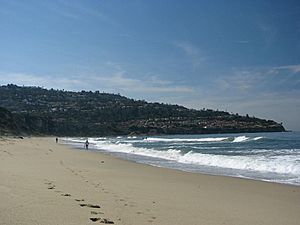
Torrance Beach is between Redondo Beach and Malaga Cove on Santa Monica Bay. The very southern part of Torrance Beach is sometimes called "Rat Beach" by locals.
The Madrona Marsh is a special wetland area in the city. It's a nature preserve that was saved from being developed. Projects have helped improve this important home for birds, wildlife, and native plants.
Torrance Weather
Torrance has a warm-summer Mediterranean climate. This means it has warm, dry summers and mild, wet winters. The rainy season is usually from November to March. Even though Torrance is near the coast, it can get surprisingly cold sometimes, with a risk of frost in winter. Areas closer to the beach or higher up tend to be milder.
| Climate data for Torrance, California (Torrance Airport), 1991–2020 normals, extremes 1932–present | |||||||||||||
|---|---|---|---|---|---|---|---|---|---|---|---|---|---|
| Month | Jan | Feb | Mar | Apr | May | Jun | Jul | Aug | Sep | Oct | Nov | Dec | Year |
| Record high °F (°C) | 91 (33) |
92 (33) |
96 (36) |
104 (40) |
98 (37) |
102 (39) |
102 (39) |
101 (38) |
111 (44) |
106 (41) |
98 (37) |
94 (34) |
111 (44) |
| Mean maximum °F (°C) | 80.8 (27.1) |
79.6 (26.4) |
81.4 (27.4) |
84.6 (29.2) |
83.1 (28.4) |
82.7 (28.2) |
86.0 (30.0) |
87.3 (30.7) |
92.0 (33.3) |
90.2 (32.3) |
85.8 (29.9) |
77.5 (25.3) |
95.5 (35.3) |
| Mean daily maximum °F (°C) | 66.8 (19.3) |
66.4 (19.1) |
67.7 (19.8) |
70.2 (21.2) |
71.8 (22.1) |
73.9 (23.3) |
76.9 (24.9) |
78.1 (25.6) |
78.1 (25.6) |
75.7 (24.3) |
70.7 (21.5) |
66.1 (18.9) |
71.9 (22.2) |
| Daily mean °F (°C) | 56.9 (13.8) |
57.0 (13.9) |
58.8 (14.9) |
60.9 (16.1) |
63.6 (17.6) |
66.2 (19.0) |
69.4 (20.8) |
70.2 (21.2) |
69.5 (20.8) |
66.4 (19.1) |
60.7 (15.9) |
56.2 (13.4) |
63.0 (17.2) |
| Mean daily minimum °F (°C) | 47.0 (8.3) |
47.6 (8.7) |
49.8 (9.9) |
51.6 (10.9) |
55.4 (13.0) |
58.5 (14.7) |
61.8 (16.6) |
62.4 (16.9) |
60.9 (16.1) |
57.1 (13.9) |
50.7 (10.4) |
46.3 (7.9) |
54.1 (12.3) |
| Mean minimum °F (°C) | 37.7 (3.2) |
39.3 (4.1) |
42.1 (5.6) |
44.3 (6.8) |
48.9 (9.4) |
52.4 (11.3) |
55.4 (13.0) |
55.2 (12.9) |
54.4 (12.4) |
49.8 (9.9) |
42.1 (5.6) |
37.1 (2.8) |
34.8 (1.6) |
| Record low °F (°C) | 24 (−4) |
27 (−3) |
23 (−5) |
28 (−2) |
37 (3) |
36 (2) |
42 (6) |
44 (7) |
41 (5) |
33 (1) |
29 (−2) |
27 (−3) |
23 (−5) |
| Average precipitation inches (mm) | 3.36 (85) |
3.66 (93) |
1.98 (50) |
0.63 (16) |
0.26 (6.6) |
0.07 (1.8) |
0.06 (1.5) |
0.00 (0.00) |
0.09 (2.3) |
0.49 (12) |
0.80 (20) |
2.24 (57) |
13.64 (346) |
| Average precipitation days | 6.2 | 6.4 | 4.9 | 2.4 | 1.4 | 0.5 | 0.5 | 0.0 | 0.4 | 2.0 | 3.1 | 5.7 | 33.5 |
| Source 1: NOAA | |||||||||||||
| Source 2: National Weather Service | |||||||||||||
People of Torrance
| Historical population | |||
|---|---|---|---|
| Census | Pop. | %± | |
| 1930 | 7,271 | — | |
| 1940 | 9,950 | 36.8% | |
| 1950 | 22,241 | 123.5% | |
| 1960 | 100,991 | 354.1% | |
| 1970 | 134,968 | 33.6% | |
| 1980 | 129,881 | −3.8% | |
| 1990 | 133,107 | 2.5% | |
| 2000 | 137,946 | 3.6% | |
| 2010 | 145,438 | 5.4% | |
| 2020 | 147,067 | 1.1% | |
| U.S. Decennial Census | |||
Torrance Population in 2020
| Race / Ethnicity (NH = Non-Hispanic) | Pop 2000 | Pop 2010 | Pop 2020 | % 2000 | % 2010 | % 2020 |
|---|---|---|---|---|---|---|
| White alone (NH) | 72,234 | 61,591 | 51,913 | 52.36% | 42.35% | 35.30% |
| Black or African American alone (NH) | 2,911 | 3,740 | 4,781 | 2.11% | 2.57% | 3.25% |
| Native American or Alaska Native alone (NH) | 360 | 304 | 235 | 0.26% | 0.21% | 0.16% |
| Asian alone (NH) | 39,210 | 49,707 | 51,857 | 28.42% | 34.18% | 35.26% |
| Native Hawaiian or Pacific Islander alone (NH) | 434 | 473 | 523 | 0.31% | 0.33% | 0.36% |
| Other Race alone (NH) | 383 | 505 | 980 | 0.28% | 0.35% | 0.67% |
| Mixed race or Multiracial (NH) | 4,777 | 5,678 | 8,698 | 3.46% | 3.90% | 5.91% |
| Hispanic or Latino (any race) | 17,637 | 23,440 | 28,080 | 12.79% | 16.12% | 19.09% |
| Total | 137,946 | 145,438 | 147,067 | 100.00% | 100.00% | 100.00% |
Torrance Population in 2010
The 2010 United States Census showed that Torrance had 145,438 people. The city had about 7,076 people per square mile (2,732 per km²).
- 51.1% were White (42.3% not Hispanic).
- 34.5% were Asian.
- 2.7% were African American.
- 0.4% were Native American.
- 0.4% were Pacific Islander.
- 5.4% were from other races.
- 5.5% were from two or more races.
- 16.1% of residents were Hispanic or Latino (of any race).
Most people (99.2%) lived in homes. About 0.3% were homeless in group living situations. There were 56,001 households. About 33.1% of these had children under 18. The average household had 2.58 people. The average family had 3.14 people. The median age in Torrance was 41.3 years. For every 100 females, there were 94.7 males. In March 2019, the average household income in Torrance was $85,070. The average family income was $102,637. Torrance has the second-highest percentage of people of Japanese background in California (8.9%).
Torrance Population in 2000
In 2000, Torrance had 137,946 people. There were 54,542 households and 36,270 families. The population density was about 6,716 people per square mile (2,593 per km²).
- 59.2% were White.
- 28.6% were Asian.
- 2.2% were Black or African American.
- 0.4% were Native American.
- 0.4% were Pacific Islander.
- 4.6% were from other races.
- 4.7% were from two or more races.
- 12.8% of the people were Hispanic or Latino of any race.
About 31.1% of households had children under 18. The average household size was 2.51 people. The average family size was 3.10 people. The median age was 39 years. For every 100 females, there were 94.7 males. In 2008, the average household income was $79,312. The average family income was $98,473. About 5.4% of the population lived below the poverty line.
Japanese American Community
As of 2014, Torrance had the second-largest number of people of Japanese background in any U.S. city, after Honolulu. Many Japanese companies have offices in Torrance, especially in the car industry. Because of this, Torrance has many Japanese restaurants and cultural places. Some people even say Torrance is "like Japan's 48th prefecture". There are Japanese supermarkets, schools, and banks.
Before World War II, the South Bay area was one of the few places where non-U.S. citizens could buy land. This is why many Japanese people settled there. When Toyota moved its U.S. operations to Torrance in 1982, many other Japanese companies followed. This was because Torrance was close to the Port of Long Beach and Los Angeles International Airport. In 2014, Toyota announced it would move its U.S. headquarters to Plano, Texas.
Korean American Community
As of 1992, about 60% of the Korean population in the South Bay area lived in Torrance and Gardena. In 1990, 5,888 people of Korean background lived in Torrance. This was a big increase from 1,652 people in 1980.
Torrance Economy
Torrance is home to the U.S. headquarters of American Honda Motor Company, a Japanese automaker, and its luxury car brand, Acura. Robinson Helicopters are designed and built in Torrance. Honeywell's Garrett turbochargers, used in car engines worldwide, are also made here. Alcoa Fastening Systems (now Arconic), which makes parts for airplanes, is based in Torrance. Other companies in Torrance include Pacific Sales, Pelican Products, Virco, and Rapiscan Systems.
Here are the top 10 employers in Torrance as of 2024:
| No. | Employer | Number of employees |
|---|---|---|
| 1 | Torrance Memorial Health System | 4,070 |
| 2 | Torrance Unified School District | 2,675 |
| 3 | Providence Little Company of Mary Medical Center | 2,429 |
| 4 | City of Torrance | 1,556 |
| 5 | American Honda Motor Co Inc. | 1,496 |
| 6 | Robinson Helicopter Company | 1,212 |
| 7 | Honeywell Aerospace | 766 |
| 8 | Moog Aircraft Group | 684 |
| 9 | PBF Energy - Torrance Refining Company | 607 |
| 10 | Arconic Fastening Systems | 583 |
The Del Amo Fashion Center is one of the five largest shopping malls in the United States. It covers 2.5 million square feet (230,000 m²). The current mall was formed when two older malls, Del Amo Center (built 1958) and Del Amo Fashion Square (built 1972), joined together in 1982. At that time, it was the largest mall in the world. The mall has been updated several times, adding new stores and an open-air shopping area.
Torrance used to have many oil wells and oil derricks because it was a major oil-producing area. Today, the Torrance oil refinery, owned by PBF Energy, produces much of the gasoline for Southern California. Torrance was also an important center for the Pacific Electric Railway.
Torrance has a small airport called Zamperini Field. It's named after Louis Zamperini, a local track star and World War II hero. The airport has about 175,000 take-offs and landings each year. For commercial flights, Los Angeles International Airport and Long Beach Airport are both about 15 minutes away.
Torrance is also home to the main bakery for King's Hawaiian bread. Younger Optics, one of Torrance's largest employers, created the first "invisible" bifocal glasses. The headquarters of Mitsuwa Marketplace and Nijiya Market, both Japanese supermarkets, are in Torrance.
Foreign Companies in Torrance
All Nippon Airways, a Japanese airline, has its United States headquarters in Torrance. Toyota Motor Sales USA moved its operations to Torrance in 1982. This was because it was easy to get to port facilities and the LAX airport. Many other Japanese companies followed Toyota to Los Angeles. As of 2014, the Los Angeles South Bay area has the largest number of Japanese companies in the United States.
Arts and Culture in Torrance
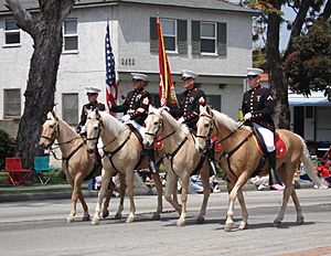
The Armed Forces Day Parade in Torrance started in 1960. It is the longest-running military parade sponsored by a city. It happens every year on Armed Forces Day and goes down Torrance Boulevard. The parade includes military vehicles, school bands, and important community members.
The Torrance Cultural Arts Center hosts many cultural events all year. The Torrance Cultural Arts Foundation (TOCA) works with the city to offer different cultural, educational, and entertainment experiences. Other groups like The Aerospace Players, Torrance Art Museum, and The Torrance Symphony also perform there.
Torrance has won awards in the Rose Parade:
- In 2010, its float Garden of Dreams won the top Lathrop K. Leishman trophy for "Most Beautiful Non-Commercial" float.
- In 2011, Torrance won the Tournament Volunteers' Trophy for best floral design.
- In 2012, the city's entry won the Governor's Trophy for best depiction of life in California.
- In 2015, a float honoring Louis Zamperini won the Theme trophy.
- In 2016, the Torrance float won the Princess trophy for most beautiful float 35 feet and under.
Historic Places in Torrance
These Torrance landmarks are listed on the National Register of Historic Places:
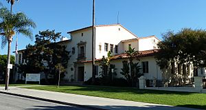
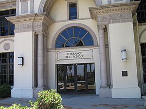
- Main Building (Torrance High School) – Built in a Mediterranean Revival architecture style in 1917 and 1921.
- Original Science Building – Current Home Economics Building (Torrance High School)
- Auditorium (Torrance High School) – Built in a Streamline Moderne style in 1938.
- Torrance Elementary School – Current High School Annex – Also in Mediterranean Revival style.
- Pacific Electric Railroad Bridge – Designed by Irving Gill in 1913.
Parks and Fun in Torrance
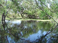
The Torrance City Parks Department takes care of the thirty Torrance City Parks. Some of these parks include:
- Wilson Park – This 44-acre (18 ha) park has picnic areas and sports facilities. It includes a gym, skatepark, and roller-hockey rink. Wilson Park also hosts the Torrance Farmers Market.
- The Southern California Live Steamers Miniature Railroad is in Wilson Park. You can get free rides on miniature live steam trains on the first Sunday and third Saturday of each month, and on the 4th of July.
- Madrona Marsh Wildlife Preserve & Nature Center – This is a rare wetlands habitat in Southern California. It has native plants, wildlife, and is great for birdwatching. There's also a Nature center with classes.
- Columbia Park – This large urban park has picnic areas, sports fields, walking paths, jogging trails, and a cross country running course. It also has a cherry blossom tree grove.
- Torrance Smart Gardening Center – Located in Columbia Park, this Community Garden offers planting beds for residents. It's also a place to learn about backyard composting.
- Living Tribute Trees park program – This program lets families or groups sponsor a new tree in a park. It's a way to honor someone or remember an event.
- Torrance Beach Park – This park is right on the Pacific Coast of Torrance. The beach here is sometimes called "RAT Beach".
- Marvin Braude Bike Trail – This paved bike path runs along the Pacific Ocean shoreline in Los Angeles County. It ends in Torrance.
Getting Around Torrance
Zamperini Field (IATA: TOA ICAO: KTOA) is a general aviation airport for smaller planes. If you need commercial flights, Los Angeles International Airport (LAX) and Long Beach Airport are about 15 minutes away.
Major roads and highways in the area include I-110, I-405, SR 91, SR 107, and SR 1. The city has its own bus service, Torrance Transit. You can also use LACMTA Metro bus and LADOT services.
Train Services
Union Pacific currently runs freight trains on what's left of the old Pacific Electric lines. These lines were built in 1911. Passenger train service stopped in 1940. The Los Angeles County Metropolitan Transportation Authority (LA Metro) plans to extend its C Line Extension to Redondo Beach. This project might be finished between 2030 and 2033. There are also plans to speed it up for the 2028 Olympics. Freight trains in Torrance are also served by BNSF and Union Pacific.
Future Metro Expansion
There have been ideas to expand the LA Metro train system into Torrance. However, some Torrance city leaders have opposed these plans. In 2023, some city council members tried to block the expansion.
Schools in Torrance
Public Schools
The Torrance Unified School District (TUSD) was created in 1947. It covers the City of Torrance and nearby areas. The district has about 21 square miles (54 km²) of land. It runs 17 elementary schools, eight middle schools, and five high schools. It also has three adult education centers and a child development center.
The five high schools in the Torrance Unified School District are:
- Torrance High School
- North High School
- South High School
- West High School
- Kurt Shery High School (a continuation school)
The eight middle schools in the Torrance Unified School District are:
- Calle Mayor Middle School
- Casimir Middle School
- Bert Lynn Middle School
- J.H. Hull Middle School
- Jefferson Middle School
- Madrona Middle School
- Philip Magruder Middle School
- Richardson Middle School
The 17 elementary schools in the Torrance Unified School District are:
- Hickory Elementary School
- John Adams Elementary School
- Torrance Elementary School
- Howard Wood Elementary School
- Anza Elementary School
- Arlington Elementary School
- Arnold Elementary School
- Carr Elementary School
- Yukon Elementary School
- Walteria Elementary School
- Riviera Elementary School
- Towers Elementary School
- Fern Elementary School
- Edison Elementary School
- Lincoln Elementary School
- Seaside Elementary School
- Victor Elementary School
Local school districts have also created the Southern California Regional Occupational Center (SCROC). This center teaches technical classes to students and adults. TUSD is also part of the California Academy of Mathematics and Science (CAMS). CAMS is a special high school for math and science students.
Private Schools
Torrance also has several private schools. These include Catholic schools like Bishop Montgomery High School, Nativity Catholic School, St James Catholic School, and St Catherine Laboure Catholic School. Protestant private schools include Ascension Lutheran School and First Lutheran School.
Colleges and Universities
Torrance is part of the El Camino Community College District. The main campus of El Camino College is mostly just outside the city limits, but a part of it is in Torrance. El Camino College started in 1947 and covers 126 acres (51 ha). In 2011, over 25,000 students attended the college each semester.
Other Education Programs
In 1980, Asahi Gakuen, a weekend Japanese-language school, began renting space at South Torrance High School. This school still uses the high school for its Torrance Campus. Asahi Gakuen's main offices are near Torrance.
News and Media
The Los Angeles Times is the main newspaper for the Los Angeles area. The Daily Breeze is a daily newspaper published in Torrance. It serves the South Bay cities of Los Angeles County. Torrance CitiCABLE is the local government TV channel. It shows news, sports, entertainment, and city council meetings.
Famous People from Torrance
- Jason "Wee-Man" Acuña, TV host and actor
- Bela Bajaria, Netflix Chief Content Officer
- Jonathan Bornstein (born 1984), soccer player
- John Butler, musician
- Larry Carlton, guitarist
- Chloe Kim, professional snowboarder, Olympic gold medalist
- Michelle Kwan, 5-time world champion figure skater and ambassador
- Ted Lieu, U.S. Representative
- Jeremy Lin, professional basketball player
- Nancy Lopez, Hall of Fame golfer
- Rami Malek, actor
- Alyson and Amanda Michalka (Aly & AJ), singers and actresses
- Chuck Norris, karate expert and actor
- Brian Ortega, mixed martial artist
- Quentin Tarantino, filmmaker
- Louis Zamperini, Olympic track star, World War II veteran, author
Sister Cities
In 1973, Torrance became a sister city with Kashiwa, Chiba, Japan. This was part of the Sister Cities International program. Since then, people from Torrance and Kashiwa have shared their cultures. The Torrance Sister City Association helps with a Japanese cultural festival and a yearly student exchange program. North High is the official sister high school of Kashiwa Municipal High. Torrance also has a sister-city relationship with Konya, Türkiye, since 1958.
See also
 In Spanish: Torrance (California) para niños
 | Kyle Baker |
 | Joseph Yoakum |
 | Laura Wheeler Waring |
 | Henry Ossawa Tanner |


