Rancho Palos Verdes, California facts for kids
Quick facts for kids
Rancho Palos Verdes, California
|
|||
|---|---|---|---|
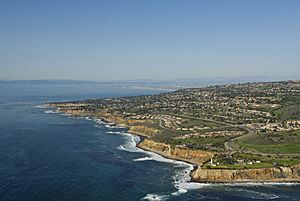
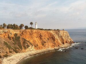
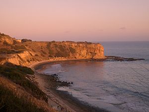
Rancho Palos Verdes Coastline
|
|||
|
|||
| Nickname(s):
RPV, PV
|
|||
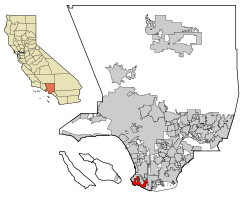
Location of the City of Rancho Palos Verdes in Los Angeles County, California
|
|||
| Country | |||
| State | |||
| County | Los Angeles | ||
| Incorporated | September 7, 1973 | ||
| Founded by | Juan Jose Sepulveda | ||
| Named for | “Ranch Of Green Sticks” | ||
| Area | |||
| • Total | 13.47 sq mi (34.89 km2) | ||
| • Land | 13.47 sq mi (34.89 km2) | ||
| • Water | 0.00 sq mi (0.00 km2) 0% | ||
| Elevation | 220 ft (67 m) | ||
| Population
(2020)
|
|||
| • Total | 42,287 | ||
| • Density | 3,082.69/sq mi (1,190.27/km2) | ||
| Time zone | UTC-8 (Pacific) | ||
| • Summer (DST) | UTC-7 (PDT) | ||
| ZIP code |
90275
|
||
| Area code(s) | 310/424 | ||
| FIPS code | 06-59514 | ||
| GNIS feature IDs | 255967, 2411516 | ||
Rancho Palos Verdes is a city on the coast in southern Los Angeles County, California. It became a city on September 7, 1973. In 2020, about 42,287 people lived there.
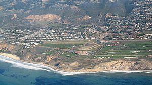
Rancho Palos Verdes is built on the high cliffs of the Palos Verdes Peninsula. It is near three other cities in the Palos Verdes Hills. These cities are Palos Verdes Estates, Rolling Hills, and Rolling Hills Estates. The city is known for its many nature areas and hiking trails. It also has a great school district and expensive homes.
Contents
History of Rancho Palos Verdes
Early Beginnings
By 1882, the land was owned by Jotham Bixby. He was from Rancho Los Cerritos. He rented the land to Japanese farmers. These families grew beans, peas, and tomatoes on the southern parts of the land. On the drier northern parts, they grew barley, hay, and grain.
Developing the Land
In 1913, a man named Frank A. Vanderlip bought a large piece of land. He bought 25 square miles on the Palos Verdes Peninsula for $1.5 million. He was known as the "Father of Palos Verdes." He worked with engineers to plan roads and survey the area.
Later, in 1921, Vanderlip let Edward Gardner Lewis take over the project. Lewis was good at developing land. But he did not have enough money to buy and build on Palos Verdes. He tried to raise money from investors. He wanted to get $30 million for improvements. He only raised $15 million, which was not enough. So, Vanderlip got the land back.
Land Movement Challenges
The Portuguese Bend area of the Palos Verdes Peninsula has had landslides for a very long time. This moving land covers about 260 acres (1.05 km²). The ground slides on a smooth surface about 100 feet (30 m) below the ground. This happens because the land layers tilt towards the ocean. The rocks are also weak, and the coast is always eroding.
In 2023, the city received over $23 million from the Federal Emergency Management Agency (FEMA). This money helps deal with the land movement in Portuguese Bend. Later that year, the city declared a local emergency. This was because the land was moving more quickly.
In July 2024, So Cal Gas stopped gas service to 135 homes. This was due to the severe land movement. On September 2, 2024, California Governor Gavin Newsom declared a state of emergency. Officials also cut power to 245 homes.
Geography
The city covers about 13.5 square miles (34.89 km²). Almost all of this area is land.
Population and People
| Historical population | |||
|---|---|---|---|
| Census | Pop. | %± | |
| 1980 | 36,577 | — | |
| 1990 | 41,659 | 13.9% | |
| 2000 | 41,145 | −1.2% | |
| 2010 | 41,643 | 1.2% | |
| 2020 | 42,287 | 1.5% | |
| U.S. Decennial Census 1850–1870 1880-1890 1900 1910 1920 1930 1940 1950 1960 1970 1980 1990 2000 2010 |
|||
Population in 2020
In 2020, Rancho Palos Verdes had 42,287 people. The city is home to many different groups of people. About 48% of the people were White. About 31% were Asian. About 10% were Hispanic or Latino.
Life in Rancho Palos Verdes
In 2010, there were about 15,561 homes in the city. About one-third of these homes had children under 18. Most homes were occupied by married couples. The average household had 2.65 people.
The population has a wide range of ages. About 22% of people were under 18. About 23% were 65 or older. The average age was 47.8 years.
In 2010, the average household income was $118,893. Only a small number of people (4.5%) lived below the poverty line. By 2021, the average household income had increased to $158,996.
Economy
Main Employers
Here are the top employers in Rancho Palos Verdes in 2020:
| # | Employer | Employees |
|---|---|---|
| 1 | Palos Verdes Peninsula Unified School District | 1,071 |
| 2 | Terranea Resort Hotel | 534 |
| 3 | Canterbury | 169 |
| 4 | Belmont Village | 168 |
| 5 | Marymount California University | 139 |
| 6 | Trump National Golf Club | 138 |
| 7 | City of Rancho Palos Verdes | 122 |
| 8 | Ralphs | 117 |
| 9 | Green Hills Memorial Park | 72 |
| 10 | Los Verdes Golf Course | 56 |
Arts and Culture
Libraries
The Palos Verdes Library District has three libraries on the Palos Verdes Peninsula.
Famous Landmarks
Point Vicente Lighthouse
The Point Vicente Lighthouse was built in 1926. It is listed on the National Register of Historic Places. The lighthouse is 67 feet (20 m) tall. It stands on a cliff that is 130 feet (40 m) high.
Wayfarers Chapel
Wayfarers Chapel is also on the National Register of Historic Places. It was designed by Lloyd Wright and built between 1949 and 1951. The chapel is known for its unique design and its location on cliffs above the Pacific Ocean. It is a memorial to Emanuel Swedenborg, a scientist from the 1700s.
In February 2024, Wayfarers Chapel closed temporarily. This was due to the land moving faster in the area. As of May 2024, the chapel is being carefully taken apart. It will be stored safely. The plan is to move it to a new location later.
Portuguese Bend and Palos Verdes Nature Preserve
The Portuguese Bend area has the largest amount of natural plants left on the Palos Verdes Peninsula. The Portuguese Bend landslide is here. It is one of the largest continuously moving landslides in North America.
In 2009, the city and the Palos Verdes Peninsula Land Conservancy bought 2 square miles (5.18 km²) of this land. They created the Palos Verdes Nature Preserve. This is the biggest protected coastal open space between San Diego and Santa Barbara.
Terranea Resort
The Terranea Resort is built where the old Marineland of the Pacific used to be. Marineland was a marine park that closed in 1987. The resort was built in 1998.
Trump National Golf Club
The Trump National Golf Club Los Angeles is a public golf course in Rancho Palos Verdes. It was designed by Pete Dye and Donald J. Trump. The Trump Organization owns it.
The 18th hole of the original course slid towards the ocean in a landslide. The previous owners went bankrupt. In 2002, The Trump Organization bought the property. They spent $27 million to completely redesign and rebuild the course. The new 18-hole Trump National Golf Club opened in 2006.
Salvation Army College
The Salvation Army has a two-year college in Rancho Palos Verdes. It is located on the old Marymount College Hawthorne Campus. This college trains officers for The Salvation Army. It also serves as the main office for the Western United States.
Animals of Rancho Palos Verdes
Like other cities on the Palos Verdes Peninsula, Rancho Palos Verdes has many wild peafowl. Frank A. Vanderlip brought these birds to the area around 1910.
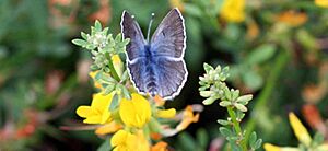
In 1982, the city started building at Hesse Park. This construction destroyed one of the largest groups of an endangered butterfly. This butterfly is called the Palos Verdes blue (Glaucopsyche lygdamus palosverdesensis).
Education
Most of the city is part of the Palos Verdes Peninsula Unified School District (PVPUSD). This district includes Palos Verdes Peninsula High School and Palos Verdes High School.
A small part of the city is in the Los Angeles Unified School District (LAUSD). Children in this area can choose to go to public schools in either district.
The PVPUSD has very high API scores. It also has high average SAT scores. Many students successfully complete Advanced Placement exams. It is one of the top school districts in Los Angeles County and California.
There are also private schools in the area. These include Rolling Hills Country Day School (for grades K-8) and Chadwick School (for grades K-12).
Marymount California University was a private college that offered degrees. It closed in August 2022. UCLA South Bay now uses the campus. The University of California system bought the campus for $80 million in 2022.
City Services
Emergency Services
The Los Angeles County Fire Department provides fire protection for Rancho Palos Verdes. McCormick Ambulance Service handles ambulance transport.
The city also works with the Los Angeles County Sheriff's Department for law enforcement. They share services with the cities of Rolling Hills and Rolling Hills Estates. The Lomita Sheriff's Station serves these cities.
The Los Angeles County Department of Health Services has a health center in Harbor Gateway. It serves Rancho Palos Verdes and nearby areas.
Notable People
Many famous people have lived in Rancho Palos Verdes. These include:
- Merrill Moses, an Olympic water polo player.
- Eli Morgan, a Major League Baseball pitcher.
- Pete Sampras, a world number one tennis player.
- Eliot Teltscher, a top-10 tennis player.
- Taylor Fritz, a top-10 tennis player.
- Shawn Weinstein, a professional basketball player.
- Christen Press, a soccer player for the United States women's national team and two-time World Cup champion.
- Barry Greenstein, a professional poker player.
- John Van Hamersveld, an artist.
- Chester Bennington, a singer from the rock band Linkin Park.
- Joan Didion, an author.
See also
 In Spanish: Rancho Palos Verdes para niños
 | Dorothy Vaughan |
 | Charles Henry Turner |
 | Hildrus Poindexter |
 | Henry Cecil McBay |


