
Rolling Hills, California facts for kids
Quick facts for kids
Rolling Hills, California
|
||
|---|---|---|
|
||

Location of Rolling Hills in Los Angeles County, California
|
||

Rolling Hills, California
Location in the United States
|
||
| Country | United States | |
| State | California | |
| County | Los Angeles | |
| Incorporated | January 24, 1957 | |
| Government | ||
| • Type | Council-Manager | |
| Area | ||
| • Total | 2.99 sq mi (7.75 km2) | |
| • Land | 2.99 sq mi (7.75 km2) | |
| • Water | 0.00 sq mi (0.00 km2) 0% | |
| Elevation | 1,276 ft (389 m) | |
| Population
(2020)
|
||
| • Total | 1,739 | |
| • Density | 581.6/sq mi (224.39/km2) | |
| Time zone | UTC-8 (Pacific) | |
| • Summer (DST) | UTC-7 (PDT) | |
| ZIP code |
90274
|
|
| Area codes | 310/424 | |
| FIPS code | 06-62602 | |
| GNIS feature IDs | 1661325, 2410986 | |

Rolling Hills is a small city in Los Angeles County, California. It is located on the Palos Verdes Peninsula. This city is known as a gated community, meaning it has private roads and three entry gates.
Rolling Hills was officially formed as a city in 1957. It has a unique, countryside feel. There are no traffic lights here. Homes are built on large lots, giving plenty of space between them. The city also has wide paths for horseback riding along its streets.
Many homes in Rolling Hills are designed in the style of 19th-century California ranch houses or Spanish haciendas. A rule in the city is that all homes must have white exterior paint. Homeowners are also required to have space on their property for horses, even if they don't own any. The community was developed by A. E. Hanson.
Residents of Rolling Hills usually go to other nearby towns for shopping, school, and other services. This is because the only businesses within Rolling Hills are the City Hall, the Community Association, and a fire station. In 2020, the city had a population of 1,739 people.
Contents
Exploring Rolling Hills Geography
Rolling Hills is bordered by other cities on the Palos Verdes Peninsula. To the north, it touches Rolling Hills Estates. On all other sides, including the south, it borders Rancho Palos Verdes. This includes an area called Portuguese Bend.
The city is located at 33°45′34″N 118°20′30″W / 33.75944°N 118.34167°W. According to the United States Census Bureau, Rolling Hills covers an area of about 3.0 square miles (7.75 square kilometers). All of this area is land.
Understanding the Climate
Rolling Hills has a cold semi-arid climate. This means it gets dry summers. Summers are often hotter than in nearby areas, with temperatures sometimes reaching 93°F (34°C) in early September.
Winters in Rolling Hills tend to be colder than surrounding areas. High temperatures are usually in the high 50s to low 60s Fahrenheit. It's also common for hailstorms to happen at least once each winter.
Population and People
Rolling Hills is known for being a wealthy area. In 2000, it was ranked as one of the richest places in the United States based on how much money people earned.
Population in 2010
In 2010, the population of Rolling Hills was 1,860 people. Most of the people living here were White (77.3%), with a significant number of Asian residents (16.3%). A smaller number of people were African American, Native American, Pacific Islander, or from other backgrounds. About 5.5% of the population was Hispanic or Latino.
The average age of residents in 2010 was about 51.7 years old. About 21.7% of the population was under 18 years old. Most people lived in homes that they owned.
Population in 2000
In 2000, Rolling Hills had a population of 1,871 people. The racial makeup was similar to 2010, with most residents being White (79.8%) and a notable Asian population (14.0%). About 4.5% of the population was Hispanic or Latino.
The average age in 2000 was 48 years. About 25.9% of the population was under 18 years old.
Education in Rolling Hills
Students in Rolling Hills attend schools within the Palos Verdes Peninsula Unified School District (PVPUSD). These schools are often ranked among the best in California and the entire country.
- Palos Verdes Peninsula High School has been recognized by the Washington Post as one of "America's Most Challenging Schools." In 2016, it was ranked as the 9th best public high school in California by niche.com.
- The Chadwick School is a well-known private school in the area. It serves students from kindergarten through 12th grade. In 2014, Business Insider named Chadwick as one of the top private high schools in America.
Community Services
The Los Angeles County Sheriff's Department (LASD) helps keep Rolling Hills safe. Their local office, called the Lomita Station, is located in Lomita.
For health services, the Los Angeles County Department of Health Services operates the Torrance Health Center. This center is located near Torrance and serves the residents of Rolling Hills.
Notable People from Rolling Hills
Many interesting people have lived in Rolling Hills, including:
- Tracy Austin: A famous tennis player who was once ranked number one in the world and won the US Open twice.
- Colin Baxter: A professional football player.
- Ethan Walden Brown: The founder and CEO of Beyond Meat, a company known for plant-based meat alternatives.
- Brandon Holt: A professional tennis player and the son of Tracy Austin.
- Parnelli Jones: A former professional race car driver and owner of an Indy car team.
- Erik Lorig: An NFL football player.
- Mike Mentzer: A bodybuilder, businessman, and author.
- Alex McLeod: A TV personality who hosted the show Trading Spaces.
- Greg Popovich: The founder and owner of Castle Rock Winery.
- Frank D. Robinson: The founder of Robinson Helicopter Company.
- John Tu: The co-founder of Kingston Technology, a major computer technology company.
Images for kids
-
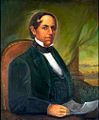
Manuel Domínguez, a signer of the Californian Constitution and owner of Rancho San Pedro, which included all of Palos Verdes.
-
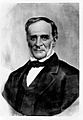
In 1846, Rancho de los Palos Verdes was separated from Rancho San Pedro and granted to José Loreto Sepúlveda (shown) and Juan Capistrano Sepúlveda.


See also
 In Spanish: Rolling Hills (condado de Los Ángeles) para niños
