
National Register of Historic Places listings in Los Angeles County, California facts for kids

Have you ever wondered about the really old and special places in Los Angeles County, California? This page is all about the amazing historic spots in the county that are listed on the National Register of Historic Places. This is like a special list of buildings, areas, and sites that are super important to the history of the United States.
There are over 580 places on this list in Los Angeles County! That includes 21 National Historic Landmarks, which are even more important. Many of these are in the big cities of Los Angeles and Pasadena, but this list focuses on the 194 cool places found in other parts of the county. Let's explore some of them!
Contents
- Historic Homes and Buildings
- Adamson House (Malibu)
- Adobe Flores (South Pasadena)
- Antelope Valley Indian Museum (Lancaster)
- Case Study House No. 20 (Altadena)
- El Molino Viejo (San Marino)
- Leonis Adobe (Calabasas)
- Los Cerritos Ranch House (Long Beach)
- Pio Pico Casa (Whittier)
- Queen Anne Cottage and Coach Barn (Arcadia)
- Workman and Temple Family Homestead Museum (City of Industry)
- Cool Theaters and Public Buildings
- Interesting Outdoor and Natural Sites
- Other Notable Places
- Places No Longer on the List
- Images for kids
Historic Homes and Buildings
Many of the places on the National Register are old homes or buildings that tell us about how people lived long ago.
Adamson House (Malibu)
The Adamson House in Malibu is a beautiful old house right by the beach. It was built in 1929 and has amazing tile work. It's a great example of Spanish Colonial Revival style.

Adobe Flores (South Pasadena)
In South Pasadena, you can find Adobe Flores. This old adobe building from the 1800s was once a home and even played a small part in California's history during the Mexican-American War.
.jpg)
Antelope Valley Indian Museum (Lancaster)
The Antelope Valley Indian Museum in Lancaster is a unique chalet-style building built into rock formations. It started as a home and now teaches us about Native American cultures in the area.

Case Study House No. 20 (Altadena)
In Altadena, there's the Case Study House No. 20. This modern house was built in 1958 as part of a special project to design new, affordable homes. It was designed for a famous graphic designer named Saul Bass.

El Molino Viejo (San Marino)
The El Molino Viejo in San Marino is super old! It's a water-powered mill built around 1816, making it the oldest commercial building in Southern California. Imagine how much history it has seen!

Leonis Adobe (Calabasas)
The Leonis Adobe in Calabasas is one of the oldest surviving adobe structures in the Los Angeles area. It was built in 1844 and shows what life was like on a large ranch back then.
.JPG)
Los Cerritos Ranch House (Long Beach)
The Los Cerritos Ranch House in Long Beach is a National Historic Landmark. This ranch house was built in 1844 and was once the headquarters of a huge cattle ranch. It's a great place to learn about California's ranching past.
.jpg)
Pio Pico Casa (Whittier)
The Pio Pico Casa in Whittier was the home of Pio Pico, the last Mexican governor of California. It's now a state historic park where you can learn about his life and the changes in California.

Queen Anne Cottage and Coach Barn (Arcadia)
Located in the Los Angeles County Arboretum and Botanic Garden in Arcadia, the Queen Anne Cottage and Coach Barn is a beautiful Victorian-style building. It looks like something out of a fairy tale!

Workman and Temple Family Homestead Museum (City of Industry)
In the City of Industry, you can visit the Workman and Temple Family Homestead Museum. This site includes the Workman Adobe (built in 1842), the Temple Mansion (from 1922), and the Workman Family Cemetery. It tells the story of two important families in early California.

Cool Theaters and Public Buildings
Many historic places are buildings where people gathered, like theaters and city halls.
Alex Theatre (Glendale)
The Alex Theatre in Glendale is a grand old movie palace built in 1925. It's known for its beautiful architecture and has hosted many shows and films over the years.

Aztec Hotel (Monrovia)
The Aztec Hotel in Monrovia is super unique! Built in 1925, it's designed to look like an ancient Aztec temple. It's a really cool example of early 20th-century architecture.

Culver Hotel (Culver City)
The Culver Hotel in Culver City is a historic landmark built in 1924. It's a flatiron-shaped building that has been a part of many Hollywood stories.

The Forum (Inglewood)
The Forum in Inglewood is a famous indoor arena built in 1967. It's hosted countless concerts, sports events, and other big shows, making it a key part of entertainment history in Los Angeles.

Pomona Fox Theater (Pomona)
The Pomona Fox Theater in Pomona is another beautiful old movie theater. Built in 1931, it was a popular spot for movies and live performances.

Saban Theatre (Beverly Hills)
The Saban Theatre in Beverly Hills, originally known as the Fox Wilshire Theatre, is a stunning example of Art Deco design. It opened in 1930 and has been a major venue for films and live shows.

Rialto Theatre (South Pasadena)
The Rialto Theatre in South Pasadena is a historic movie theater built in 1925. It's known for its unique Egyptian-style design and was a popular spot for moviegoers for many years.

Interesting Outdoor and Natural Sites
Not all historic places are buildings! Some are natural areas or special outdoor features.
Arroyo Seco Parkway Historic District
The Arroyo Seco Parkway Historic District is a very old and important road! It's one of the first freeways in the United States, built in 1940. It connects Downtown Los Angeles to Pasadena and passes through South Pasadena. It's a cool example of early highway design.

Christmas Tree Lane (Altadena)
In Altadena, you'll find Christmas Tree Lane, which is a street lined with deodar cedar trees that are decorated with lights every Christmas season. It's been a beloved tradition for over 100 years!

Mount Lowe Railway (Altadena)
North of Altadena, in the Angeles National Forest, are the remains of the Mount Lowe Railway. This was a mountain railway built in the late 1800s that took people up to enjoy amazing views and resorts. It's a cool piece of engineering history.

Point Vicente Light (Rancho Palos Verdes)
The Point Vicente Light is a lighthouse in Rancho Palos Verdes. Built in 1926, it has guided ships along the coast for nearly a century. It's a beautiful landmark with stunning ocean views.

Vasquez Rocks (Agua Dulce)
Vasquez Rocks in Agua Dulce is a natural rock formation that looks like something from another planet! These rocks have been used as a filming location for many movies and TV shows, and they also have a long history with Native American tribes.

Other Notable Places
There are many other interesting places on the list, including:
- The Beverly Wilshire Hotel in Beverly Hills, a very famous and fancy hotel.
- The RMS Queen Mary in Long Beach, a huge ocean liner that is now a hotel and museum.
- The Tuna Club of Avalon on Catalina Island, a historic fishing club.
- Several old post offices in cities like Beverly Hills, Burbank, Glendale, and Long Beach, which are great examples of architecture from the early 1900s.
Places No Longer on the List
Sometimes, places are removed from the National Register. This can happen if they are changed too much, or if they are moved. For example, the Southern Pacific Railroad Depot in Whittier was removed when it was moved to a new spot, but then it was added back to the list at its new location!
A few other places that were once on the list include:
- The James George Bell House in Bell.
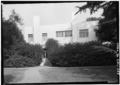
- The Walter L. Dodge House in West Hollywood.
- The famous Hughes H-4 Hercules (also known as the "Spruce Goose") in Long Beach, a giant airplane that was once the largest in the world.
- The Little Rock Creek Dam near Pearland.
- The Pacific Coast Club in Long Beach.
Images for kids
-
Walter L. Dodge House
