Agua Dulce, California facts for kids
Quick facts for kids
Agua Dulce, California
|
|
|---|---|

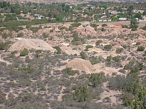
Agua Dulce as seen from Vasquez Rocks
|
|

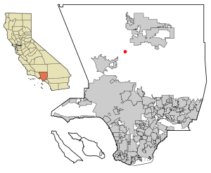
Location within Los Angeles County
|
|
| Country | United States |
| State | California |
| County | Los Angeles |
| Named for | Spanish for "sweet water" |
| Area | |
| • Total | 22.86 sq mi (59.20 km2) |
| • Land | 22.85 sq mi (59.18 km2) |
| • Water | 0.01 sq mi (0.01 km2) 0.02% |
| Elevation | 2,526 ft (770 m) |
| Population
(2020)
|
|
| • Total | 3,451 |
| • Density | 151.03/sq mi (58.31/km2) |
| Time zone | UTC-8 (Pacific (PST)) |
| • Summer (DST) | UTC-7 (PDT) |
| ZIP codes |
91390
|
| Area code(s) | 661 |
| GNIS feature IDs | 1660235; 2582928 |
| FIPS code | 06-00450 |
Agua Dulce (which means "Sweet Water" in Spanish) is a small community in Los Angeles County, California. It is located northeast of Santa Clarita. The area is about 2,526 feet (770 meters) above sea level.
In 2020, about 3,451 people lived in Agua Dulce. The community covers an area of about 22.86 square miles (59 square kilometers). Agua Dulce is also a stop on the famous Pacific Crest Trail.
Contents
Where is Agua Dulce?
Agua Dulce is found along California State Route 14. It is located about halfway between Santa Clarita and Palmdale. This community is about 45 miles (72 kilometers) north of Los Angeles. It sits in the Sierra Pelona Valley region of Southern California.
One very famous spot in Agua Dulce is Vasquez Rocks. The Pacific Crest Trail, a long hiking path from Mexico to Canada, also passes through this area.
Who Lives in Agua Dulce?
According to the 2020 census, 3,451 people call Agua Dulce home. Most people in Agua Dulce live in family homes. Many households have children under 18. The average family size is about three people.
The community has a mix of ages. Many residents are between 45 and 64 years old. The median age in Agua Dulce is about 47 years. Most homes in Agua Dulce are owned by the people who live in them.
Schools in Agua Dulce
Agua Dulce is part of the Acton-Agua Dulce Unified School District. Here are some of the schools that serve the area:
- Vasquez High School, Acton
- High Desert Middle School, Acton
- Meadowlark School, Acton
- Agua Dulce Elementary School, Agua Dulce
Agua Dulce: A Filming Hotspot

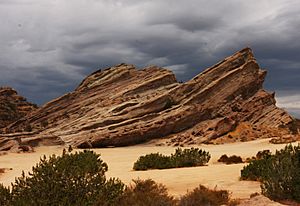
Vasquez Rocks in Agua Dulce has been a very popular place for Hollywood movies and TV shows to film. Its unique rock formations make it a great backdrop.
Some famous movies filmed here include:
- The Flintstones
- Mel Brooks' Blazing Saddles
- Duel
- Rat Race
- Bill & Ted's Bogus Journey
Many TV shows have also used Vasquez Rocks. These include:
- The Invaders episode "The Saucer"
- The Star Trek episode "Arena"
- Reno 911
The History channel also filmed its reality TV show "Top Shot" in the hills around Agua Dulce. Music videos for artists like Tom Petty and the Heartbreakers and Weird Al Yankovic have also been shot here.
The rocks are named after a famous bandit named Tiburcio Vásquez. He used the rocks as a hiding place a long time ago.
More recently, Agua Dulce was the main setting for Jordan Peele’s 2022 horror sci-fi movie Nope. The main characters in the film are horse wranglers. They often work on movie shoots that happen around Agua Dulce.
Getting Around Agua Dulce
Agua Dulce has a small airport called Agua Dulce Airpark. This airport is used for general aviation, which means smaller planes. The Airpark and the area around it were also used for the ABC game show 101 Ways to Leave a Gameshow. This show first aired in 2011.
See also
 In Spanish: Agua Dulce (California) para niños
 | Jackie Robinson |
 | Jack Johnson |
 | Althea Gibson |
 | Arthur Ashe |
 | Muhammad Ali |


