Sylmar, Los Angeles facts for kids
Quick facts for kids
Sylmar
|
|
|---|---|
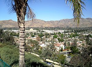
View of western Sylmar, facing north
|
|
| Nickname(s):
The Top of Los Angeles
|
|
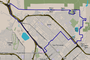
Sylmar, as delineated by the Los Angeles Times
|
|
| Country | United States |
| State | California |
| County | Los Angeles |
| City | Los Angeles |
| Named for | portmanteau of silva and mare, Latin words meaning "forest" and "sea" respectively |
| Elevation | 1,270 ft (390 m) |
| Population
(2008)
|
|
| • Total | 79,614 |
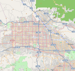
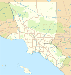
Sylmar is a neighborhood located in the northern part of Los Angeles, California. It's part of the San Fernando Valley. Sylmar is famous for its many olive orchards. The name "Sylmar" comes from two Latin words: silva meaning "forest" and mare meaning "sea."
The area's history goes back to the 1700s with the San Fernando Mission. In the late 1800s, olive farming became a big deal here. Sylmar was also known for its healthy climate, which led to hospitals being built in the area. Today, Sylmar has many public and private schools for students.
Contents
History of Sylmar
In 1874, this area was first called Morningside. Later, in 1893, its name changed to "Sylmar." This new name combined Latin words for "forest" and "sea." It referred to the huge number of olive trees growing there.
By 1894, about 1,700 acres were covered with olive trees. By 1906, it was the largest olive grove in the world! During harvest time in the early 1900s, many workers helped pick the olives. A large packing plant also employed hundreds of people.
In 1898, the olive growers planned to divide the land into smaller sections. They wanted to create 5-acre blocks, each with its own street. They hoped this would help more people buy land and grow olives.
In 1922, a company bought 300 acres to create a new town called Sylmar. This land was near the big olive grove. They planned to sell smaller "city lots" for homes.
Later, in 1938, the Sylmar Packing Corporation offered its large property for sale. It had olives, lemons, oranges, and figs. Part of it was set aside for a new town called Olive View. The rest was divided into smaller farm lots.
Sylmar After World War II
After World War II, Sylmar began to change. In 1962, city planners wanted to build more homes and apartments. They also planned for more industrial areas and shopping centers. Residents were not happy with these changes, as they wanted to keep the area more rural.
Sylmar grew a lot after major freeways were completed in 1963 and 1981. These freeways made it much easier to travel to and from the community.
The 1971 San Fernando earthquake caused a lot of damage in Sylmar. Many houses were destroyed, and people had to live in tents. Basic services like water and gas were cut off. It took time for the community to recover.
A few months after the earthquake, a methane gas explosion happened in a tunnel being built under Sylmar. This terrible accident killed 17 workers. It led to new, stricter safety rules for mining and tunneling in California. A memorial was built in 2013 to remember the victims.
In 1971, city planners wanted to keep Sylmar's quiet, rural feel. They aimed to limit population growth to protect its "houses, horses, and orchards" image.
By the 1980s, Sylmar was still mostly rural. However, some industrial areas were developing. It was one of the fastest-growing areas in the San Fernando Valley between 1980 and 1990. The population grew by over 30% during that time.
The reopening of the Olive View Medical Center in 1986 also brought more people and businesses to Sylmar. By 1986, the population reached over 53,000.
The 1994 Northridge earthquake also affected Sylmar, causing fires that destroyed many homes. Sylmar is sometimes called "The Top of Los Angeles" because it's the city's northernmost neighborhood.
A study in 2005 noted that Sylmar had changed a lot. It used to be a rural community focused on horses. But by then, many new residents had moved in, leading to concerns about housing and public services.
By 2006, Sylmar's open spaces were quickly being developed. Many long-time residents worried that this growth would change their equestrian lifestyle. They loved having large lots for horses and trails leading into the mountains.
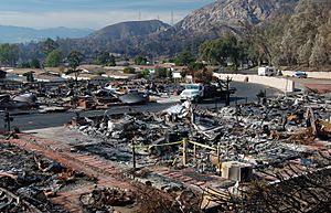
In 2008, the Sayre Fire caused the worst loss of homes due to fire in Los Angeles's history. Nearly 500 homes in or near Sylmar were destroyed. In 2016, the Marek Fire also destroyed 41 homes.
In 2018, a part of northwest Sylmar was named "Rancho Cascades." On January 7, 2025, the Hurst Fire broke out near Sylmar, causing a lot of smoke and ash in the area.
Community Safety
Preventing Dangerous Driving
In the 1990s, there were concerns about illegal street racing in Sylmar. These races attracted many young people and led to dangerous accidents. Officials worked to stop these activities. For example, in 1994, a popular gathering spot was ordered to improve lighting and security to prevent illegal cruising.
Geography of Sylmar
Sylmar is located on a gently sloping plain. Its elevation rises from about 1,100 feet near San Fernando Road to over 1,700 feet at Hubbard Street. The land then becomes steeper as it reaches the San Gabriel Mountains to the north.
Sylmar is bordered by the Tujunga Canyons to the north and Lopez and Kagel canyons to the east. It also touches the cities and neighborhoods of San Fernando, Mission Hills, and Granada Hills.
Climate in Sylmar
Sylmar has a dry and sunny climate, typical of the Los Angeles Basin. It gets about 17 inches of rain each year. Snow is very rare in the San Fernando Valley, but the nearby Angeles National Forest often has snow in winter.
Even though Sylmar is only about 20 miles from the Pacific Ocean, it can be much hotter than the Los Angeles coast in summer. Winters are also cooler. In summer, the average high temperature is about 95°F, and in winter, the average high is around 66°F.
| Climate data for Sylmar, Los Angeles | |||||||||||||
|---|---|---|---|---|---|---|---|---|---|---|---|---|---|
| Month | Jan | Feb | Mar | Apr | May | Jun | Jul | Aug | Sep | Oct | Nov | Dec | Year |
| Mean daily maximum °F (°C) | 65 (18) |
67 (19) |
69 (21) |
74 (23) |
78 (26) |
85 (29) |
92 (33) |
93 (34) |
87 (31) |
80 (27) |
71 (22) |
65 (18) |
77 (25) |
| Mean daily minimum °F (°C) | 43 (6) |
43 (6) |
44 (7) |
46 (8) |
50 (10) |
55 (13) |
59 (15) |
60 (16) |
58 (14) |
52 (11) |
46 (8) |
42 (6) |
50 (10) |
| Average precipitation inches (mm) | 4.44 (113) |
4.60 (117) |
4.17 (106) |
1.08 (27) |
0.49 (12) |
0.13 (3.3) |
0.03 (0.76) |
0.21 (5.3) |
0.40 (10) |
0.66 (17) |
1.52 (39) |
2.43 (62) |
20.16 (512) |
People of Sylmar
The population of Sylmar has grown significantly over the years. In 1940, there were about 3,500 people. By 2000, the population reached nearly 70,000. In 2021, the population was estimated to be over 80,000.
Sylmar is considered a "moderately diverse" neighborhood in Los Angeles. In 2000, a large percentage of residents were of Latino heritage. Many residents born outside the United States came from Mexico and El Salvador.
Most homes in Sylmar are owned by the people who live in them. The average household size is about 3.6 people, which is higher than the average for Los Angeles. The median yearly income for households in 2008 was about $65,783.
Arts and Culture in Sylmar
Sylmar is home to the Nethercutt Collection. This museum is famous for its amazing collection of classic cars. It also has old musical instruments, antique furniture, and even a historic train.
Historical Places
- The Cascades is a special channel that marks the end of the Los Angeles Aqueduct system. This system brings water from the Owens Valley, over 300 miles away! It's a recognized historical landmark.
- The San Fernando Pioneer Memorial Cemetery is the oldest non-religious cemetery in the San Fernando Valley. The first burial there was in 1892. It is also a California Historical Landmark.
Libraries
The Los Angeles Public Library operates the Sylmar Branch Library. It's located at the corner of Polk Street and Glenoaks Boulevard.
Parks and Recreation
Sylmar has several parks and recreation areas for residents to enjoy.
- The City of Los Angeles Sylmar Recreation Center has auditoriums, sports courts, a children's play area, and picnic tables. It also has an indoor gym and tennis courts.
- The Stetson Ranch Park is one of the city's two parks specifically for horse riding.
- Los Angeles County operates the El Cariso Community Regional Park. This park was dedicated to firefighters who died in the Loop Fire in 1966. It has sports fields, play areas, picnic spots, and a swimming pool.
- The county also runs the Veterans Memorial Park. This park was built on the site of a former veterans hospital. It has barbecue areas, camping spots, and a disc golf course.
- The Sylmar Hang Gliding Association has its Flight Park on Gridley Street. Visitors can often watch people hang gliding there.
Government and Services
Local Government
In 1943, Sylmar volunteers helped create their own fire station. Today, the Los Angeles Fire Department operates Fire Station 91 in Sylmar. The Los Angeles Police Department serves Sylmar from its Mission Community Police Station.
Representation
- Sylmar is represented in the United States Senate by California's Senators Laphonza Butler and Alex Padilla.
- In the U.S. House of Representatives, Sylmar is part of California's 29th congressional district, represented by Democrat Tony Cárdenas.
- At the state level, Sylmar is in California's 43rd State Assembly district, represented by Democrat Luz Rivas, and California's 20th State Senate district, represented by Democrat Caroline Menjivar.
- Locally, Sylmar is in Los Angeles City Council District 7, represented by Monica Rodriguez.
Education in Sylmar
About 11% of Sylmar residents aged 25 and older have a four-year college degree. This percentage is lower than the average for the city and county.
Schools in Sylmar
Public Schools
- Los Angeles Mission College, 13356 Eldrige Avenue
- Sylmar Senior High School, 13050 Borden Avenue (opened in 1961)
- PUC Triumph Charter High School, 13361 Glenoaks Boulevard
- Evergreen Continuation School, 13101 Dronfield Avenue
- Olive Vista Middle School, 14600 Tyler Street (opened in 1958)
- PUC Triumph Academy, charter middle school, 13361 Glenoaks Blvd.
- PUC Lakeview Charter High School, 13361 Glenoaks Boulevard
- PUC Community Charter Elementary School, 14019 Sayre Street
- Hubbard Street Elementary School, 13325 Hubbard Street
- Barry J. Nidorf Juvenile Hall, 16350 Filbert Street
- Herrick Avenue Elementary School, 13350 Herrick Avenue
- Sylmar Elementary School, 13291 Phillippi Avenue (opened in 1946)
- Harding Street Elementary School, 13060 Harding Street
- El Dorado Avenue Elementary School, 12749 El Dorado Avenue
- Dyer Street Elementary School, 14500 Dyer Street
- Osceola Street Elementary School, 14940 Osceola Street
- Vista del Valle Dual Language Academy, 12441 Bromont Avenue
- Sylmar Biotech Health Academy, 13050 Borden Avenue (established 2012)
- Options for Youth (OFY), 13752 Foothill Blvd
- Discovery Charter Preparatory School, 13570 Eldridge Avenue (moved here in 2016)
Private Schools
- First Lutheran High School, 13361 Glenoaks Boulevard
- Concordia Junior-Senior High School, 13570 Eldridge Avenue. This school was formed by combining Los Angeles Lutheran High School and First Lutheran San Fernando.
- St. Anne's Academy, 13982 Tucker Avenue
- Our Lady of Victory School, K–12, 14024 Bridle Ridge Road
- Sunland Christian School, K–12, 13216 Leach Street
- Poverello of Assisi Preschool, 13367 Borden Avenue
- Park Montessori Children's Center, 13130 Herrick Avenue
- St. Didacus Elementary School, 14325 Astoria Street
Infrastructure and Services
Police Services
The Los Angeles Police Department provides police services to Sylmar through its Mission Community Police Station.
Healthcare
Olive View–UCLA Medical Center is located in Sylmar. This hospital first opened as a place for people to recover from illnesses.
Youth Facilities
El Retiro School for Girls was a boarding school for girls who were under the care of the Los Angeles County court system. It operated from 1919 to 1961. A juvenile hall also opened in Sylmar in 1965.
Transportation
Sylmar is served by several major highways, including Interstate 5 (Golden State Freeway), Interstate 210 (Foothill Freeway), and Interstate 405 (San Diego Freeway).
Public transportation is available through Los Angeles County Metropolitan Transportation Authority (Metro) buses. Metrolink also provides commuter train service at the Sylmar/San Fernando station on the Antelope Valley Line.
Notable People from Sylmar
- Mark Foster, lead singer of the band Foster the People
- Tor Johnson (1902–1971), a Swedish-American wrestler and actor
- Alex Mejia, a professional baseball player (born in Sylmar)
- Pete Redfern, a professional baseball player
- Bobby Chacon (1951–2016), a professional boxer and two-time boxing champion
See also
 In Spanish: Sylmar para niños
- Pacific Converter station (electrical)
 | Jewel Prestage |
 | Ella Baker |
 | Fannie Lou Hamer |


