
Barrio Logan, San Diego facts for kids
Quick facts for kids
Barrio Logan, San Diego
|
|
|---|---|
| Barrio Logan | |

Barrio Logan neighborhood sign near corner of Cesar E. Chavez Parkway and Main Street
|
|

Barrio Logan, San Diego
Location in San Diego
|
|
| Country | |
| State | |
| County | |
| City | |
Barrio Logan is a vibrant neighborhood in south central San Diego, California. It sits along the San Diego Bay. This area is known for its strong community and rich cultural history. It is bordered by other neighborhoods like East Village and Logan Heights.
Contents
History of Barrio Logan
When the Spanish first arrived, they found a Kumeyaay village near Chollas Creek. This shows the area has been home to people for a very long time.
How Barrio Logan Got Its Name
In 1871, a politician named John A. Logan helped create a law. This law would give land for a railroad to end in San Diego. A street was named Logan Heights after him in 1881. This name then spread to the whole area. The railroad plans never worked out. By the early 1900s, the area was mostly homes. It became one of San Diego's oldest communities.
Growth of the Community
Around 1910, many people came to Barrio Logan. They were refugees from the Mexican Revolution. Soon, they became the main group living there. Because of this, the southern part of Logan Heights became known as Barrio Logan. Barrio is a Spanish word meaning "neighborhood."
Fishing and Industry in Barrio Logan
From the early 1900s, Barrio Logan became important for San Diego's tuna industry. Companies like Pacific Tuna Canning and Van Camp Seafood Company (now Chicken of the Sea) offered many jobs. People from Italy, Mexico, Japan, and Portugal worked there. Japanese families lived in a community called Fish Camp by the bay. These homes were built on stilts. This community was removed during World War II.
Changes to the Neighborhood
Barrio Logan used to have easy access to the beach. But during World War II, this changed. The Naval Station San Diego and other military bases expanded. This took away the community's beach access. The neighborhood faced more challenges in the 1950s and 1960s. New rules allowed factories to be built near homes.
Freeway and Bridge Construction
In 1963, Interstate 5 was built right through the middle of the community. Then, in 1969, the San Diego–Coronado Bridge was built. This bridge covered much of the neighborhood with concrete pillars. The city council had promised to build a park under the bridge. A spot was chosen in June 1969.
The Birth of Chicano Park
In April 1970, construction started at the park site. But the community learned it was for a state building, not a park. This led to a peaceful protest. Students and residents took over the site. They stopped the construction for twelve days. People planted trees and flowers. A local artist, Salvador Torres, suggested painting murals on the bridge pillars. After many talks, the land was given back for a park. Chicano Park was then built and dedicated. It grew over time and by 1990, it reached the bay. This finally gave the community beach access again.

Modern Barrio Logan
Barrio Logan has many industrial areas. These include shipbuilding and other port activities. But it also has many homes. In 2013, a new plan for the community was approved. It aimed to create a "buffer zone" of shops between homes and factories. However, the shipbuilding industry disagreed. They led a campaign, and voters rejected the plan in 2014. A new plan is currently being developed.
Since 2015, an event called Chicano-Con has taken place. It happens at the same time as San Diego Comic-Con. In 2017, California officially recognized Barrio Logan as a cultural district. This showed the importance of Chicano history in the state.
Chicano Park: A Cultural Landmark
Barrio Logan is often called el ombligo, which means "the navel" or center of the world. This is because of its deep cultural roots.

Chicano Park is a special public park in Barrio Logan. Local residents helped create it. It was born from the 1970 protest and land takeover. This event sparked a cultural rebirth for the Mexican-American community. The park has over 60 colorful murals. These are painted on the concrete pillars of the San Diego–Coronado Bridge and Interstate 5. Chicano Park became an official historic site in San Diego in 1980. It was added to the National Register of Historic Places in 2013.
Economy of Barrio Logan
Barrio Logan is home to important facilities. These include Naval Base San Diego, also known as 32nd Street Naval Station. The NASSCO shipyard is also here. These provide many jobs related to the military and shipping.
The neighborhood also has many artist studios and galleries. It hosts an "Art Crawl" regularly. This event lets people explore the local art scene. The idea of painting murals in Chicano Park was discussed as early as 1967. Sew Loka is a local business that makes fashionable clothing. It recently held a fashion show to promote "slow fashion." This idea focuses on making clothes in a sustainable and ethical way.
Governance in Barrio Logan
Barrio Logan is part of City Council District 8. Councilman Vivian Moreno represents the area. The Barrio Logan Community Planning Group was formed in October 2014. This group helps plan for the community's future. Barrio Logan was once a "redevelopment area." This meant it received special funding for improvements. However, California ended all redevelopment areas in 2012.
Transportation in Barrio Logan

The area has public transportation. The San Diego Trolley serves the neighborhood. You can catch a train at the Barrio Logan station.
Images for kids
-
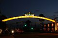
Barrio Logan neighborhood sign near corner of Cesar E. Chavez Parkway and Main Street
-
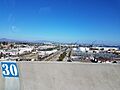
An industrial area and port facilities on San Diego Bay
-
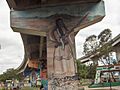
Murals in Chicano Park
-
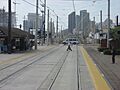
San Diego Trolley station in Logan
