South Gate, California facts for kids
Quick facts for kids
South Gate, California
|
|||
|---|---|---|---|
|
|||
| Nickname(s):
"Azalea City"
|
|||

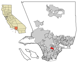
Location of South Gate in Los Angeles County, California
|
|||
| Country | United States | ||
| State | California | ||
| County | Los Angeles | ||
| Incorporated | January 20, 1923 | ||
| Area | |||
| • Total | 7.35 sq mi (19.04 km2) | ||
| • Land | 7.24 sq mi (18.74 km2) | ||
| • Water | 0.12 sq mi (0.30 km2) 1.59% | ||
| Elevation | 115 ft (35 m) | ||
| Population
(2020)
|
|||
| • Total | 92,726 | ||
| • Rank | 89th in California | ||
| • Density | 12,616/sq mi (4,870.1/km2) | ||
| Time zone | UTC-8 (PST) | ||
| • Summer (DST) | UTC-7 (PDT) | ||
| ZIP Code |
90280
|
||
| FIPS code | 06-73080 | ||
| GNIS feature ID | 1652795 | ||
South Gate is a city in Los Angeles County, California, United States. It is one of the largest cities in the county. The city covers about 7.4 square miles (19.2 square kilometers). South Gate is located about 7 miles (11 kilometers) southeast of Downtown Los Angeles. It is part of a group of cities known as the Gateway Cities in southeastern Los Angeles County.
The city was officially formed on January 20, 1923. It is known as the "Azalea City" because it chose the azalea flower as its symbol in 1965. In 2020, about 92,726 people lived in South Gate. In 1990, South Gate received the All-America City Award. This award recognizes communities that work together to solve local problems.
Contents
History of South Gate
Early People in South Gate
South Gate is located in the traditional land of the Gabrielino people. These Native Americans lived in the area long ago. Some stories say that Gabrielino villages were once located at South Gate Park. Another rumored site was near the old City Hall. A village called Tajauta was also located close by.
Land Grants and Early Settlers
One of California's first important families was the Lugos. They were among the early Spanish settlers. The Lugo family received a large land grant. This land grant covered much of what is now South Gate.
Don Antonio Maria Lugo was born in 1775. He was a Spanish soldier and a respected person. In 1810, the King of Spain gave Lugo about 30,000 acres (121 square kilometers) of land. This was a reward for his and his father's military service. Later, the area near the southern entrance of this large ranch became the City of South Gate.
How South Gate Grew
By the late 1870s, much of the original Lugo land was divided. It was broken into smaller sections of about 40 acres (16 hectares). By 1880, farming became the main industry. Before this, raising cattle was more important.
Between 1910 and 1940, most farms became homes and factories. Developers helped the area grow quickly. They divided the land into small plots. These plots were sold to working-class people. Many early homes were built by the owners themselves. They used their own hard work instead of hiring others. The local economy also relied a lot on growing food in the city.
The Tweedy Family's Role
R.D. Tweedy was born in Illinois in 1812. He traveled to California in 1852 by ox-drawn cart. His family was large, and several generations lived in South Gate. The Tweedy family bought about 2,000 acres (8 square kilometers) of land. Much of South Gate was built on this land. The main shopping area in the city is still called the Tweedy Mile.
Becoming a City
The city was first named South Gate Gardens in 1918. This name came from a part of the Cudahy Ranch. Five years later, in 1923, the city was officially formed. It used the shorter name, South Gate. The name refers to the city's location. It is south of the larger city of Los Angeles.
Geography and Climate
South Gate covers a total area of about 7.4 square miles (19.2 square kilometers). Most of this area is land. A small part, about 0.1 square miles (0.3 square kilometers), is water. The Los Angeles River flows through the eastern side of South Gate.
South Gate has a warm, dry climate. Winters are mild, and summers are hot and dry. The city gets about 14.8 inches (376 millimeters) of rain each year. Most of the rain falls between November and April. Temperatures usually range from 40°F (4°C) to 110°F (43°C). The average daily temperature is between 54°F (12°C) and 73°F (23°C).
Population and People
| Historical population | |||
|---|---|---|---|
| Census | Pop. | %± | |
| 1930 | 19,632 | — | |
| 1940 | 26,945 | 37.3% | |
| 1950 | 51,116 | 89.7% | |
| 1960 | 53,831 | 5.3% | |
| 1970 | 56,909 | 5.7% | |
| 1980 | 66,784 | 17.4% | |
| 1990 | 86,284 | 29.2% | |
| 2000 | 96,375 | 11.7% | |
| 2010 | 94,396 | −2.1% | |
| 2020 | 92,726 | −1.8% | |
| U.S. Decennial Census | |||
In 2020, South Gate had a population of 92,726 people. The city's population density was about 12,838 people per square mile. Most of the people living in South Gate are of Hispanic or Latino background. This group made up about 94.95% of the population in 2020. Other groups include White, Black or African American, Native American, and Asian residents.
In 2010, about 99.9% of the people lived in homes. About 31.1% of the population was under 18 years old. About 7.0% of the population was 65 years or older. The average age in South Gate was 29.4 years.
In recent years, the median household income in South Gate was around $52,321. This means half of the households earned more and half earned less. Some families and individuals faced economic challenges. For adults aged 25 and over, about 56.7% had a high school degree or higher. About 9.4% had a bachelor's degree or higher.
Religious Life
South Gate has many different churches. There are about 40 churches in the city. They represent various religious groups. About 53.4% of people in South Gate consider themselves religious. The largest group is Catholic, followed by Protestant faiths. Other religions include the Church of Jesus Christ of Latter-day Saints, Jewish, "eastern faiths," and Muslim.
Ancestry in South Gate
Many people in South Gate have Mexican and Salvadoran family backgrounds. These are common ancestries in the city.
Economy
The income per person in South Gate is about $11,566. This figure includes all adults and children. The median income for a household is about $41,064. This means half of the households earn more and half earn less.
City Services and Transportation
Roads and Highways
Major roads help people travel in and out of South Gate. These include Interstate 710 and Imperial Highway.
Public Transportation
South Gate is served by public buses. These include Metro Local and Metro Rapid buses. The city also has its own bus service. It is called the Get Around Town Express (GATE). This service helps people travel within the city.
City Parks for Fun
South Gate has nine city parks for everyone to enjoy.
- South Gate Park is the largest park. It covers about 96.8 acres (39.2 hectares). Many community programs happen here. It has a Municipal Auditorium, Girls Club House, and a 9-hole golf course. There is also a Senior Recreation Center, Swim Stadium, and Sports Center. The park has sports fields, basketball courts, and playgrounds. You can also find tennis courts, a skate park, and picnic areas. The park closes at 10:00 pm.
- Hollydale Regional Park is 56.0 acres (22.7 hectares). It has a playground, tennis courts, and sports fields. There is also an Equestrian Center. The park closes at sunset.
- Cesar Chavez Park covers 9.0 acres (3.6 hectares). It has two playgrounds and a covered area called a pergola. It's a great spot for picnics. The park closes at sunset.
- Circle Park is a neighborhood park. It is 4.0 acres (1.6 hectares) with a playground and a ball field. It closes at sunset.
- Hollydale Community Park is 2.2 acres (0.9 hectares). It has a playground, outdoor basketball courts, and a Community Center. This park closes at 10:00 pm.
- State Street Park is a neighborhood park with grass fields. It is 0.8 acres (0.3 hectares) and closes at sunset.
- Gardendale Tot Lot is a small neighborhood park. It is 0.45 acres (0.18 hectares) with a playground. It closes at sunset.
- Triangle Park is 0.3 acres (0.12 hectares). It has a pergola, seating, a bike rack, and a drinking fountain. It closes at sunset.
- Stanford Park is a small neighborhood park. It is 0.19 acres (0.077 hectares) with a playground. It closes at sunset.
Education in South Gate
South Gate has many schools. There are 21 public schools, including elementary, middle, and high schools. There are also two private schools. Adults can take classes at the junior and senior high schools. Three community colleges and three California State Universities also serve the city.
Public Schools
Most of South Gate is part of the Los Angeles Unified School District. Some small parts of the city are served by the Paramount Unified School District and the Downey Unified School District.
LAUSD Elementary Schools
- Bryson Avenue Elementary School (opened 1931)
- Independence Elementary School (opened 1997)
- Liberty Boulevard Elementary School (opened 1932)
- Madison Elementary School (opened 2005)
- Montara Avenue Elementary School (opened 1988)
- San Gabriel Avenue Elementary School (opened 1920)
- San Miguel Avenue Elementary School (opened 1989)
- Stanford Avenue Elementary School (opened 1924)
- Stanford New Primary Center (opened 2004)
- State Street Elementary School (opened 1932)
- Tweedy Elementary School (opened 1950)
- Victoria Avenue Elementary School (opened 1925)
- Willow Avenue Elementary School (opened 2012)
LAUSD Charter Schools
- Firestone (opened 2010)
- Aspire Gateway (opened 2010)
- Valiente College Preparatory Charter School (opened 2015)
- KIPP Corazon (opened 2017)
LAUSD Middle Schools
- International Studies Learning Center
- South Gate Middle School (opened 1941)
- South East Middle School (opened 2004)
- Southeast DREAMS Magnet School (opened 2018)
LAUSD High Schools
- South Gate High School (opened 1932)
- South East High School (opened 2005)
- Legacy High School
- Odyssey Continuation High School
Other Public Schools
- Hollydale School (K-8) - part of Paramount Unified School District
- Paramount High School - part of Paramount Unified School District
Private Schools
- Lollypop Lane Preschool and Kindergarten
- Redeemer Lutheran School
- Saint Helen Elementary School
- Academia Betel (high school)
Colleges and Universities
- South Gate Satellite Campus, East Los Angeles College
Public Libraries
The County of Los Angeles Public Library operates two libraries in South Gate:
- Leland R. Weaver Library (4035 Tweedy Boulevard)
- Hollydale Library (12000 South Garfield Avenue)
Famous People from South Gate
Many notable people have connections to South Gate, including:
- Arleen Auger, an opera singer
- Don Buchla, who invented a music synthesizer
- Cypress Hill, a well-known hip hop/rap group
- Mark Gonzales, a professional skateboarder
- Lee Greenwood, a country music artist
- Doug Harvey, a Hall of Fame baseball umpire
- Dave Lombardo, drummer for the band Slayer
- Pete Rozelle, a former Commissioner of the National Football League
- Glenn Seaborg, a Nobel Prize winner
See also
 In Spanish: South Gate (California) para niños
 | Bayard Rustin |
 | Jeannette Carter |
 | Jeremiah A. Brown |


