
Escondido, California facts for kids
Quick facts for kids
Escondido, California
|
|||||
|---|---|---|---|---|---|
.jpg)  .jpg)  .jpg) Clockwise from top right: aerial view of Escondido; City Hall; Deer Park Monastery; Center City High School; Downtown
|
|||||
|
|||||
| Motto(s):
"City of Choice!"
|
|||||

Location of Escondido in San Diego County, California
|
|||||

Escondido, California
Location in California

Escondido, California
Location in the United States
|
|||||
| Country | |||||
| State | |||||
| County | |||||
| Incorporated | October 8, 1888 | ||||
| Government | |||||
| • Type | Council-Manager | ||||
| Area | |||||
| • Total | 37.45 sq mi (97.00 km2) | ||||
| • Land | 37.34 sq mi (96.72 km2) | ||||
| • Water | 0.11 sq mi (0.28 km2) 0.48% | ||||
| Elevation | 646 ft (197 m) | ||||
| Population
(2020)
|
|||||
| • Total | 151,038 | ||||
| • Rank | 4th in San Diego County 38th in California |
||||
| • Density | 4,060.12/sq mi (1,567.61/km2) | ||||
| Time zone | UTC−8 (Pacific) | ||||
| • Summer (DST) | UTC−7 (PDT) | ||||
| ZIP codes |
92025–92027, 92029
|
||||
| Area codes | 442/760 | ||||
| FIPS code | 06-22804 | ||||
| GNIS feature IDs | 1652706, 2410455 | ||||


Escondido is a city in San Diego County, California, United States. Its name means "Hidden" in Spanish. It was officially made a city in 1888. This makes it one of the oldest cities in San Diego County. About 151,000 people lived there in 2020.
Contents
- What Does "Escondido" Mean?
- A Look Back: Escondido's History
- Escondido's Location and Landscape
- How Many People Live in Escondido?
- Working and Shopping in Escondido
- Arts and Fun in Escondido
- Sports in Escondido
- Parks and Outdoor Fun
- Learning in Escondido
- Getting Around Escondido
- Places of Worship
- Famous People from Escondido
- Images for kids
- See also
What Does "Escondido" Mean?
The name "Escondido" comes from a Spanish word meaning "hidden." Some say it referred to "hidden water" or a "hidden valley." Others believe it meant "hidden treasure."
A Look Back: Escondido's History
The area where Escondido is now was first home to the Luiseño people. They set up camps and villages along the creek. They called the place Mixéelum Pompáwvo. Another village was called Panakare. The Kumeyaay people also lived nearby. Most of these early villages are gone today due to building and farming.
Spanish and Mexican Times

Spain ruled this land from the late 1700s to the early 1800s. They built missions to teach the native people. When Mexico became independent from Spain, the land was split into large ranchos. Most of Escondido sits on what was once Rancho Rincon del Diablo. This land was given to Juan Bautista Alvarado in 1843.
In 1846, during the Mexican–American War, a fight called the Battle of San Pasqual happened southeast of Escondido. Mexican forces fought against American forces. A park in Escondido is named after Kit Carson, an American leader in that battle.
The American Era

When California became a state in 1850, many Spanish-speaking people lived here. Later, more settlers came from the Midwest. The 1880s saw a big "land boom" in Southern California.
In 1853, there was a plan to divide California and create a new territory. A judge thought the capital could be in Rancho Rincon del Diablo. He hoped a railroad would pass through the area. This plan didn't happen.
In 1868, the rancho was sold to new owners. In 1883, a group of investors bought the land. They formed the Escondido Land and Town Company. In 1888, Escondido officially became a city. Railroads like the Santa Fe were built in the 1880s. The opening of U.S. Route 395 in 1930 helped Escondido grow.

Escondido was mostly a farming town at first. People grew muscat grapes. After a dam was built in 1894-1895, creating Lake Wohlford, many orange and lemon trees were planted. Olive and walnut trees also grew. By the 1960s, avocados became the biggest crop. Today, much of the farmland has become housing, but some farms, like vineyards and avocado orchards, still exist in the San Pasqual Valley.
Escondido's Location and Landscape
Escondido covers about 37 square miles. Most of it is land, with a small amount of water. The city is next to San Marcos to the west and northern San Diego to the south.
City Areas
- Downtown Escondido is around Grand Avenue. It has coffee shops, restaurants, stores, art galleries, and a comedy club. The historic Ritz Theater is also there.
- Old Escondido Historic District has many old homes built in the late 1800s and early 1900s. These homes are in Victorian and Craftsman styles. It's a short walk from Downtown.


The Escondido Creek flows through the city. It starts at Lake Wohlford Dam and goes through downtown. It eventually flows into the San Elijo Lagoon. A bike path runs along most of the creek.
The community of Valley Center is just northeast of Escondido. The Valley View Casino is located there.
Escondido has different types of natural plants, like chaparral (brushland), oak woodlands, and grasslands. The Daley Ranch Preserve, north of the city, is a great place to see these plants and wildlife like deer and bobcats.

Weather in Escondido
Escondido has a mix of a semi-arid climate (meaning it's quite dry) and a hot-summer Mediterranean climate (like places around the Mediterranean Sea). This means it has hot summers and cool, wet winters. Because it's inland, it gets warmer than cities right on the coast during summer and cooler in winter.
The city gets about 15 inches of rain each year. Most of the rain falls from November to March. Snow is very rare. The mild weather allows avocados and oranges to grow well here. The hottest temperature ever recorded in Escondido was 115°F (46°C) in September 2020. The coldest was 13°F (-11°C) in January 1901 and 1913.
| Climate data for Escondido No 2, California (1991–2020 normals, extremes 1893–present) | |||||||||||||
|---|---|---|---|---|---|---|---|---|---|---|---|---|---|
| Month | Jan | Feb | Mar | Apr | May | Jun | Jul | Aug | Sep | Oct | Nov | Dec | Year |
| Record high °F (°C) | 92 (33) |
95 (35) |
97 (36) |
103 (39) |
106 (41) |
109 (43) |
112 (44) |
103 (39) |
115 (46) |
106 (41) |
100 (38) |
96 (36) |
115 (46) |
| Mean maximum °F (°C) | 83.0 (28.3) |
83.3 (28.5) |
85.9 (29.9) |
90.3 (32.4) |
92.1 (33.4) |
94.4 (34.7) |
98.1 (36.7) |
99.7 (37.6) |
101.8 (38.8) |
96.8 (36.0) |
88.5 (31.4) |
80.9 (27.2) |
104.7 (40.4) |
| Mean daily maximum °F (°C) | 68.8 (20.4) |
68.7 (20.4) |
71.0 (21.7) |
74.2 (23.4) |
76.7 (24.8) |
81.9 (27.7) |
87.2 (30.7) |
89.0 (31.7) |
86.9 (30.5) |
80.8 (27.1) |
74.6 (23.7) |
68.0 (20.0) |
77.3 (25.2) |
| Daily mean °F (°C) | 56.8 (13.8) |
57.3 (14.1) |
59.9 (15.5) |
63.0 (17.2) |
66.6 (19.2) |
71.1 (21.7) |
75.8 (24.3) |
77.2 (25.1) |
75.0 (23.9) |
69.1 (20.6) |
61.9 (16.6) |
55.9 (13.3) |
65.8 (18.8) |
| Mean daily minimum °F (°C) | 44.8 (7.1) |
45.9 (7.7) |
48.9 (9.4) |
51.8 (11.0) |
56.4 (13.6) |
60.2 (15.7) |
64.4 (18.0) |
65.3 (18.5) |
63.1 (17.3) |
57.3 (14.1) |
49.1 (9.5) |
43.8 (6.6) |
54.3 (12.4) |
| Mean minimum °F (°C) | 34.0 (1.1) |
36.4 (2.4) |
39.4 (4.1) |
43.1 (6.2) |
48.0 (8.9) |
52.5 (11.4) |
58.0 (14.4) |
57.6 (14.2) |
54.1 (12.3) |
47.1 (8.4) |
39.0 (3.9) |
33.4 (0.8) |
31.7 (−0.2) |
| Record low °F (°C) | 13 (−11) |
20 (−7) |
20 (−7) |
24 (−4) |
30 (−1) |
35 (2) |
38 (3) |
36 (2) |
32 (0) |
25 (−4) |
20 (−7) |
15 (−9) |
13 (−11) |
| Average precipitation inches (mm) | 3.19 (81) |
3.57 (91) |
2.20 (56) |
0.99 (25) |
0.35 (8.9) |
0.09 (2.3) |
0.12 (3.0) |
0.06 (1.5) |
0.16 (4.1) |
0.57 (14) |
1.08 (27) |
2.14 (54) |
14.52 (369) |
| Average precipitation days (≥ 0.01 in) | 6.4 | 6.9 | 5.8 | 4.0 | 2.6 | 0.9 | 0.7 | 0.4 | 1.0 | 2.3 | 3.7 | 6.3 | 41 |
| Source: NOAA | |||||||||||||
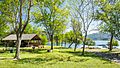
Fun at Dixon Lake

Dixon Lake is in northern Escondido. It's a great spot for picnics, camping, and fishing. You don't need a state fishing license here, but you do need a daily lake permit. You can buy these at the concession stand. The city regularly adds different types of fish, like bass, bluegill, catfish, and trout. There's also an annual Trout Derby event at the lake.
How Many People Live in Escondido?
| Historical population | |||
|---|---|---|---|
| Census | Pop. | %± | |
| 1890 | 541 | — | |
| 1900 | 755 | 39.6% | |
| 1930 | 3,421 | — | |
| 1940 | 4,560 | 33.3% | |
| 1950 | 6,544 | 43.5% | |
| 1960 | 16,377 | 150.3% | |
| 1970 | 36,792 | 124.7% | |
| 1980 | 64,355 | 74.9% | |
| 1990 | 108,635 | 68.8% | |
| 2000 | 133,559 | 22.9% | |
| 2010 | 143,911 | 7.8% | |
| 2020 | 151,038 | 5.0% | |
| 2023 (est.) | 149,799 | 4.1% | |
| U.S. Decennial Census | |||
Population Details from 2020
| Race / Ethnicity (NH = Non-Hispanic) | Pop 2000 | Pop 2010 | Pop 2020 | % 2000 | % 2010 | % 2020 |
|---|---|---|---|---|---|---|
| White alone (NH) | 69,305 | 58,142 | 50,693 | 51.89% | 40.40% | 33.56% |
| Black or African American alone (NH) | 2,734 | 3,046 | 3,267 | 2.05% | 2.12% | 2.16% |
| Native American or Alaska Native alone (NH) | 776 | 577 | 479 | 0.58% | 0.40% | 0.32% |
| Asian alone (NH) | 5,812 | 8,491 | 11,650 | 4.35% | 5.90% | 7.71% |
| Pacific Islander alone (NH) | 251 | 306 | 325 | 0.19% | 0.21% | 0.22% |
| Other Race alone (NH) | 184 | 201 | 664 | 0.14% | 0.14% | 0.44% |
| Mixed race or Multiracial (NH) | 2,804 | 2,822 | 5,734 | 2.10% | 1.96% | 3.80% |
| Hispanic or Latino (any race) | 51,693 | 70,326 | 78,226 | 38.70% | 48.87% | 51.79% |
| Total | 133,559 | 143,911 | 151,038 | 100.00% | 100.00% | 100.00% |
Population Details from 2010
In 2010, Escondido had 143,911 people. About 60% were White, 2.5% African American, 1% Native American, and 6.1% Asian. Nearly half of the population (48.9%) was Hispanic or Latino.
Most people (98.5%) lived in homes. There were about 45,484 households. Many households (41.7%) had children under 18. The average household had about 3 people.
The population included many young people: 27.6% were under 18, and 10.7% were aged 18 to 24. The average age was 32.5 years old.
Working and Shopping in Escondido

People in Escondido work in many different jobs. Many work in healthcare, education, retail, construction, and other services.
Top Job Providers
Here are some of the biggest employers in Escondido:
| # | Employer | # of Employees |
|---|---|---|
| 1 | Palomar Medical Center | 2,906 |
| 2 | Escondido Union School District | 2,077 |
| 3 | City of Escondido | 959 |
| 4 | Escondido Union High School District | 881 |
| 5 | Toyota of Escondido | 368 |
| 6 | Bergelectric | 354 |
| 7 | The Home Depot | 332 |
| 8 | Vons | 266 |
| 9 | The Classical Academies | 225 |
| 10 | Ne-Mo's Bakery | 216 |
Stone Brewing Co., a well-known brewery, moved its main office to Escondido in 2006. Dr. Bronner's Magic Soaps is also located in the city.
Places to Shop
- The Farmers Market in downtown Escondido sells fresh fruits, vegetables, and flowers grown in California.
- The Escondido Swap Market has been open for over 40 years. You can find new and used items, plus food.
- Westfield North County is an indoor shopping mall that opened in 1986. It has stores like JC Penney, Macy's, and Target.
Arts and Fun in Escondido


Downtown Escondido has become a lively place with new restaurants, cafes, and art galleries.
The California Center for the Arts is located near City Hall. It has two theaters, an art museum, and a conference center. Grape Day Park, next to the center, is home to the Escondido History Center. This museum shows the city's past with its original Santa Fe Depot, first library, and old Victorian house.
The San Diego Children's Discovery Museum is also nearby. It has hands-on exhibits for kids up to 10 years old. The Pioneer Room at the Escondido Public Library has old photos, maps, and stories about Escondido's history.
On Friday evenings from April to September, you can see "Cruisin' Grand." This is a car show on Grand Avenue with vintage cars made before 1970.
The Escondido Arts Partnership helps support local art. They host the Second Saturday Art Walk, where you can visit different galleries and museums. They also have a Municipal Gallery and an art library.
Distinction Gallery on Grand Avenue is known for its unique art, especially surrealism.
Sports in Escondido
- From 1964 to 1968, the San Diego Chargers football team held their training camp in Escondido.
- In 1981, the Escondido National Little League team made it to the Little League World Series. They won several games to get there.
- There were plans to build a baseball stadium in Escondido for the AAA Portland Beavers team, but the plans did not go through.
- The San Diego Sabers hockey team used to play in Escondido before moving to Carlsbad.
Parks and Outdoor Fun
Parks to Explore
Escondido has fifteen parks for everyone to enjoy:
- Daley Ranch is a huge 3,058-acre area. It's protected to keep its unique plants and animals safe. It has over 20 miles of trails for hiking, mountain biking, and horseback riding. Popular trails include the Boulder Loop Trail and the Ranch House Loop. You can see oak trees, chaparral, and wildlife like deer and hawks.
- El Norte Park is a small park with mature trees and a playground.


- Kit Carson Park is a large 285-acre park. It has 3 ponds, sports fields, playgrounds, a disc golf course, and an arboretum. It's also home to Queen Califia's Magical Circle, a unique sculpture garden by French artist Niki de Saint Phalle.
- Grape Day Park is behind the Escondido City Hall. It's named after an annual grape harvest event that used to happen there.
- Jesmond Dene Park has ball fields, a playground, and BBQ areas.

- Dixon Lake provides fresh water to Escondido. It's a popular spot for fishing, and you can rent boats. Swimming is not allowed. There are also campsites and trails around the lake.
- Lake Wohlford is in the northeast part of Escondido. It has walking trails and allows fishing. There's also a cafe by the lake.
- Rod McLeod Park is a green space with a playground, paved trails, and picnic areas.
- Washington Park is an urban park with lighted fields for baseball, softball, tennis, and basketball. It also has a swimming pool and a children's pool.
- Frances Ryan Park is a 67-acre complex with soccer fields.
- Grove Park was built around 2008 and is named to honor the city's farming past.
San Diego Zoo Safari Park
The San Diego Zoo Safari Park is located close to Escondido. It's like a sister park to the San Diego Zoo. At the Safari Park, you can see animals living in large, open areas.
Learning in Escondido
Most of Escondido is served by the Escondido Union Elementary School District and Escondido Union High School District. The city has 19 elementary schools, seven middle schools, and seven high schools.
Escondido Adult School offers classes for adults. These include high school diploma programs, English as a Second Language (ESL) classes, and job training courses, especially in medical fields.
Public High Schools
- Escondido High School
- Orange Glen High School
- San Pasqual High School
- Classical Academy High School
- Escondido Charter High School
- Valley High School
- Del Lago Academy: Campus of Applied Science
- Balboa School
Middle Schools
- Classical Academy Middle School
- Bear Valley Middle School
- Del Dios Middle School
- Heritage Junior High School
- Hidden Valley Middle School
- Mission Middle School
- Rincon Middle School
- Quantum Academy Middle School
- Limitless Learning Academy
Elementary Schools
- Bernardo Elementary
- Central Elementary
- Classical Academy
- Coastal Academy
- Conway Elementary
- Farr Avenue Elementary
- Felicita Elementary
- Glen View Elementary
- Heritage Elementary
- Juniper Elementary
- L. R. Green Elementary
- Lincoln Elementary
- Miller Elementary
- North Broadway Elementary
- Oak Hill Elementary
- Orange Glen Elementary
- Pioneer Elementary
- Reidy Creek Elementary
- Rock Springs Elementary
- Rose Elementary
The Escondido Public Library has a main branch, a special Pioneer Room for history, a computer center, and a bookmobile.
Westminster Seminary California and John Paul the Great Catholic University are also located in Escondido.
Getting Around Escondido

Transportation Options

Two main highways serve Escondido: Route 78 and Interstate 15. Route 78 comes from Oceanside in the west. I-15 goes north to Temecula and south to San Diego.

The North County Transit District (NCTD) runs local bus services. The Escondido Transit Center is a main hub for buses. You can also connect to other bus systems from here.

The Sprinter is a train service that connects the Escondido Transit Center to Oceanside. It opened in 2008. In Oceanside, you can connect to other train lines like the Coaster and Amtrak's Pacific Surfliner.
Escondido was also considered as a stop for a future high-speed rail system in California.
City Services
San Diego Gas & Electric provides electricity for the city. The City of Escondido Water Utilities provides water to most residents.
Places of Worship
- Westminster Seminary California is in Escondido.
- The Meeting of the Lord Monastery is located outside of Escondido.
- Ascension Lutheran Church is a Christian church in Escondido.
- Deer Park Monastery is a Buddhist sanctuary in the hills north of Escondido. It is guided by the famous Zen teacher Thich Nhat Hanh.
Famous People from Escondido
Many notable people have connections to Escondido:
- Anacani: a singer with the Lawrence Welk orchestra
- Tom Anderson: co-founder of MySpace
- Lester Bangs: a rock music critic
- Ken Block: rally car driver and founder of DC Shoes
- Sam Brannan: California's first millionaire
- Ray Conniff: a famous bandleader
- Richard Denning: actor from movies like An Affair to Remember
- Steve Hendrickson: former Chargers football player
- George Horine: held a world record in high jump and won an Olympic medal
- Randy Johnson: Major League baseball player
- Jacque Jones: former baseball player for the Minnesota Twins
- Jovan Kirovski: soccer player for the L.A. Galaxy
- Korey Lee: Major League Baseball player
- Jim Londos: a professional wrestler
- Shannon MacMillan: professional soccer player
- Mark Redman: professional baseball player
- Steve Reeves: bodybuilder and actor, known for Hercules
- Sean Salisbury: former NFL quarterback and ESPN anchorman
- Eric Weddle: former NFL free safety for the San Diego Chargers
- Royce Williams: a Navy pilot hero from the Korean War
- Harold Bell Wright: a popular author in the 1920s and 1930s
- Andrea Zittel: a contemporary artist
- Kevin Kiner: film and television composer
- Madison Cunningham: musician
Images for kids
-
Picnic areas at Dixon Lake
See also
 In Spanish: Escondido (California) para niños
