Luiseño facts for kids
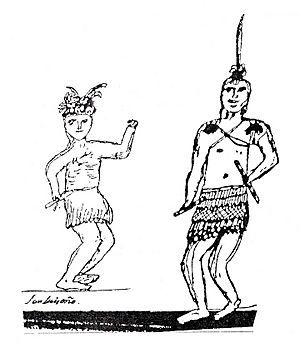
Drawing of Luiseño men in traditional dance regalia, by Pablo Tac (Luiseño, 1822–1844)
|
|
| Total population | |
|---|---|
| 2,500 (including Ajachmem people) | |
| Regions with significant populations | |
| Languages | |
| Luiseño, English, and Spanish | |
| Religion | |
| Traditional tribal religion, Christianity | |
| Related ethnic groups | |
| Ajachmem (Juaneño), Cupeño, Cahuilla, Serrano, Gabrielino-Tongva, Kumeyaay, and Chemehuevi |
The Luiseño people, also known as Payómkawichum, are an Indigenous group from California. When Spanish explorers first arrived in the 1500s, the Luiseño lived along the southern California coast. Their territory stretched about 50 miles (80 km) from what is now southern Los Angeles County to northern San Diego County, and about 30 miles (48 km) inland.
In their own language, the Luiseño call themselves Payómkawichum, which means "People of the West." Later, Spanish missionaries named them "Luiseños" because they lived near Mission San Luis Rey de Francia. Today, there are six federally recognized Luiseño tribes in southern California, each with their own reservation. Another group is not officially recognized by the government.
Contents
A Look at Luiseño History
Life Before European Contact
The Payómkawichum people were very skilled at using the natural resources around them. They found food and made clothing from the land. They had a strong connection with their environment. They gathered many native plants, including seeds, berries, nuts, fruits, and vegetables. This gave them a healthy and varied diet.
The land also had many animals. Men hunted antelopes, deer, rabbits, and other game. They also hunted smaller animals like mice and squirrels. The Luiseño even used a special plant, the California buckeye, to help catch fish in mountain creeks.
Experts believe that before Europeans arrived, about 4,000 to 10,000 Luiseño people lived in the area.
The Spanish Mission Period
The first Spanish missions were built in California starting in 1769. For nearly 30 years, the Payómkawichum saw many travelers pass through their lands. These travelers used a route called El Camino Real.
In 1798, Spanish missionaries built Mission San Luis Rey de Francia right in the middle of Payómkawichum territory. This mission was known as the "King of the Missions." It was founded on June 13, 1798, by Father Fermín de Lasuén. Today, the mission is in Oceanside, California, in northern San Diego County.
Changes Under Mexican Rule
After Mexico won its independence from Spain in 1821, the Mexican Empire took control of the Payómkawichum lands. In 1822, Mexican soldiers took all the coastal lands from the Payómkawichum. Much of this land was then given to Mexican settlers, known as Californios, to develop for farming.
The Mexican-American War's Impact
The Payómkawichum did not actively fight in the Mexican-American War. However, they faced violence after the Battle of San Pasqual. Some Mexican soldiers stole horses from the Pauma Band of the Luiseño. The Pauma Band caught the thieves. An American convinced the Luiseño to execute the thieves. This event became known as the Pauma Massacre.
When Mexican General José María Flores heard about this, he sent troops to get revenge. These troops joined with a group of Cahuilla people. The combined forces attacked the Payómkawichum near Temecula. Many Payómkawichum people were killed in this battle, known as the Temecula massacre. Later, American soldiers arrived and allowed the survivors to bury their dead.
Life in the American Period
After the Mexican-American War, Luiseño leaders tried to sign treaties to protect their lands. However, these treaties were never officially approved. When California became a state, a law allowed white Americans to force Indigenous Californians into a type of forced labor.
In 1875, President Ulysses S. Grant allowed reservations to be created for Native Americans. That same year, the state of California forced the Payómkawichum out of the Temecula Valley. Their land was given to American ranchers. In 1882, more reservations were allowed by President Chester A. Arthur. This happened after the unfairness of the Temecula eviction was revealed.
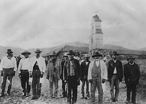
Boarding schools were also created to try and make Payómkawichum children adopt American culture. Children were sent to schools like the Sherman Indian School in Riverside. However, some Luiseño bands, like the Pauma, Pala, and Rincon Bands, fought for their children to attend local schools.
In the 1890s, valuable gems were found near the Pala Reservation. These included pink tourmaline and other beautiful stones. Pink tourmaline became a very important export. The Dowager Empress Cixi of the Qing Dynasty in China loved this gem. It was the tribe's main export until 1911.
In the 1980s, gambling became legal on reservations. This allowed the Payómkawichum to open several casinos in the 2000s. These include the Pala Casino Resort and Spa (2000), Pechanga Resort & Casino (2002), and Harrah's Resort Southern California (2004). This new income helped the Pechanga Band buy the naming rights to the San Diego Sports Arena, now called Pechanga Arena.
In 2007, the Poomacha Fire badly damaged the La Jolla Indian Reservation. About 92% of the reservation was destroyed. State and federal agencies helped the tribe rebuild. Residents were able to return to their homes by the end of the next year.
The Luiseño Language
The Luiseño language is part of the Cupan group of Takic languages. These languages belong to the larger Uto-Aztecan family. Today, about 30 to 40 people still speak the Luiseño language. Some bands are working hard to preserve their language. They are creating learning materials and singing traditional songs in Luiseño.
A scholar named Pablo Tac, who was born in 1822, created a written form of the Luiseño language. He used his knowledge of Latin and Spanish grammar to do this. His work helped people understand Luiseño, even though he had to adapt it to European writing styles.
Luiseño Tribal Bands
Today, Luiseño people are part of several recognized tribes and one unrecognized tribe:
| Reservation | Location | Associated Village(s) | Political Recognition | Population | Area in mi2 (km2) | Includes
ORTL? |
||
|---|---|---|---|---|---|---|---|---|
| Land | Water | Total | ||||||
| La Jolla Band of Luiseño Indians | San Diego County | Húyyulkum
Táaxanashpa |
Federal; 1875 | 476 | 13.50 (34.96) | 0 | 13.50 (34.96) | no |
| Pala Band of Luiseño Indians | San Diego County | Páala | Federal; 1903 | 1,315 | 20.35 (52.71) | 0 | 20.35 (52.71) | no |
| Pauma Band of Luiseño Indians | San Diego County | Páawma | Federal; 1882 | 206 | 9.36 (24.25) | 0 | 9.36 (24.25) | no |
| Pechanga Band of Luiseño Indians | Riverside County | Pichaang | Federal; 1882 | 346 | 7.01 (18.16) | 0.0024 (0.0061) | 7.02 (18.17) | no |
| Rincon Band of Luiseño Indians | San Diego County | Wáșxa | Federal; 1875 | 1,215 | 6.16 (15.96) | 0 | 6.16 (15.96) | yes |
| Soboba Band of Luiseño Indians | Riverside County | Șuvóova | Federal; 1883 | 482 | 10.62 (27.50) | 0.19 (0.48) | 10.80 (27.97) | yes |
| *San Luis Rey Band of Mission Indians | San Diego County | Qéeʼish | Municipal (City of Oceanside); 2018 | |||||
| *This group has not been recognized by the BIA. | ||||||||
Important Luiseño Villages
The Luiseño people lived in many villages across what is now Riverside and San Diego Counties. Some of their important villages included:
- In Riverside County: Awa’ (Aguanga), Pichaang (Pechanga), and Șuvóowu (Soboba).
- In San Diego County: Páala (Pala), Páawma (Pauma), and Wáșxa (Rincon).
Notable Luiseño People
- Pete Calac (1892–1968), a football player
- Freddy Herrera, a musician
- James Luna (1950–2018), a performance artist
- Jamie Okuma (b. 1977), a beadwork artist and fashion designer
- Fritz Scholder (1937–2005), a painter and sculptor
- Ruth-Ann Thorn (b. 1965), an art dealer and documentary filmmaker
- Pablo Tac (1822–1841), a scholar
See also
 In Spanish: Luiseño para niños
 | Valerie Thomas |
 | Frederick McKinley Jones |
 | George Edward Alcorn Jr. |
 | Thomas Mensah |


