Kettleman City, California facts for kids
Quick facts for kids
Kettleman City
|
|
|---|---|

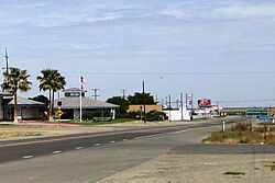
Kettleman City in 2008
|
|

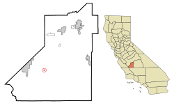
Location in Kings County and the state of California
|
|
| Country | United States |
| State | |
| County | |
| Area | |
| • Total | 0.211 sq mi (0.546 km2) |
| • Land | 0.211 sq mi (0.546 km2) |
| • Water | 0.000 sq mi (0.000 km2) |
| Elevation | 253 ft (77 m) |
| Population
(2020)
|
|
| • Total | 1,242 |
| • Density | 5,886/sq mi (2,274.7/km2) |
| Time zone | UTC-8 (PST) |
| • Summer (DST) | UTC-7 (PDT) |
| ZIP code |
93239
|
| Area code(s) | 559 |
| FIPS code | 06-38394 |
| GNIS feature ID | 1652733 |
Kettleman City is a small community in Kings County, California, United States. It's known as a census-designated place (CDP), which means it's a special area identified by the U.S. Census Bureau for statistics, but it's not an officially incorporated city with its own local government.
Kettleman City is located about 28 miles (45 km) southwest of Hanford and 54 miles (88 km) south of Fresno. It sits at an elevation of 253 feet (77 meters). This community is part of the larger Hanford-Corcoran Metropolitan Statistical Area. In 2020, about 1,242 people lived here.
If you're traveling between big cities like Los Angeles and either San Francisco or Sacramento on Interstate 5, Kettleman City is almost exactly halfway. Because of this, it's a very popular spot for travelers to stop for food, gas, and a place to rest.
Contents
Where is Kettleman City?
Kettleman City is located on the western side of the San Joaquin Valley. It sits at the base of the Kettleman Hills, which are small mountains. Long ago, this area was near the edge of a large lake called Tulare Lake.
The community covers about 0.2 square miles (0.5 square kilometers) of land. There are two main parts to Kettleman City. The first is a busy commercial area called Kettleman Junction. This is where Interstate 5 and State Route 41 meet, and it's full of gas stations, restaurants, and hotels.
The second part is the residential area, where people live. It also has some shops and county government buildings. This area is about 1.2 miles (1.9 km) north of the junction on State Route 41. The California Aqueduct, a large canal that carries water across California, runs between these two areas.
What is the climate like?
Kettleman City has a semi-arid climate, which means it's usually hot and dry. This is typical for the San Joaquin Valley. Summers are very hot and dry, while winters are cool and can have thick fog, known as tule fog.
On average, the area gets about 7.50 inches (191 mm) of rain each year. Most of this rain falls between November and April. The area is in hardiness zone 9a, which tells you what kinds of plants can grow there.
| Climate data for Kettleman City, California, 1991–2020 normals, extremes 1955–present | |||||||||||||
|---|---|---|---|---|---|---|---|---|---|---|---|---|---|
| Month | Jan | Feb | Mar | Apr | May | Jun | Jul | Aug | Sep | Oct | Nov | Dec | Year |
| Record high °F (°C) | 79 (26) |
84 (29) |
92 (33) |
99 (37) |
106 (41) |
116 (47) |
115 (46) |
114 (46) |
116 (47) |
102 (39) |
91 (33) |
79 (26) |
116 (47) |
| Mean maximum °F (°C) | 68.2 (20.1) |
73.9 (23.3) |
82.9 (28.3) |
91.7 (33.2) |
99.5 (37.5) |
105.6 (40.9) |
108.3 (42.4) |
106.5 (41.4) |
102.9 (39.4) |
93.9 (34.4) |
81.3 (27.4) |
69.5 (20.8) |
108.3 (42.4) |
| Mean daily maximum °F (°C) | 56.6 (13.7) |
63.3 (17.4) |
69.5 (20.8) |
75.5 (24.2) |
84.4 (29.1) |
92.4 (33.6) |
98.7 (37.1) |
97.5 (36.4) |
92.2 (33.4) |
81.4 (27.4) |
67.3 (19.6) |
57.5 (14.2) |
78.0 (25.6) |
| Daily mean °F (°C) | 46.3 (7.9) |
51.5 (10.8) |
56.4 (13.6) |
61.7 (16.5) |
69.9 (21.1) |
77.1 (25.1) |
83.1 (28.4) |
81.8 (27.7) |
76.4 (24.7) |
66.4 (19.1) |
54.2 (12.3) |
46.5 (8.1) |
64.3 (17.9) |
| Mean daily minimum °F (°C) | 36.0 (2.2) |
39.6 (4.2) |
43.4 (6.3) |
48.0 (8.9) |
55.4 (13.0) |
61.7 (16.5) |
67.5 (19.7) |
66.2 (19.0) |
60.6 (15.9) |
51.4 (10.8) |
41.2 (5.1) |
35.6 (2.0) |
50.6 (10.3) |
| Mean minimum °F (°C) | 27.0 (−2.8) |
29.8 (−1.2) |
33.4 (0.8) |
37.7 (3.2) |
44.4 (6.9) |
50.7 (10.4) |
56.4 (13.6) |
58.8 (14.9) |
50.8 (10.4) |
40.0 (4.4) |
30.9 (−0.6) |
25.2 (−3.8) |
23.0 (−5.0) |
| Record low °F (°C) | 15 (−9) |
22 (−6) |
26 (−3) |
31 (−1) |
35 (2) |
39 (4) |
48 (9) |
50 (10) |
46 (8) |
25 (−4) |
23 (−5) |
17 (−8) |
15 (−9) |
| Average precipitation inches (mm) | 1.39 (35) |
1.47 (37) |
1.46 (37) |
0.59 (15) |
0.37 (9.4) |
0.04 (1.0) |
0.13 (3.3) |
0.02 (0.51) |
0.06 (1.5) |
0.16 (4.1) |
0.57 (14) |
1.24 (31) |
7.50 (191) |
| Average precipitation days (≥ 0.01 in) | 6.0 | 6.0 | 5.9 | 3.7 | 1.4 | 0.5 | 0.2 | 0.3 | 0.5 | 1.3 | 3.6 | 6.6 | 36.0 |
| Source: NOAA | |||||||||||||
What does Kettleman City look like?
At the freeway exit, Kettleman City has many fast-food restaurants. The community doesn't have big grocery stores, only smaller convenience markets. You won't find many street lights or sidewalks here.
A Look Back: History of Kettleman City
The Kettleman Hills got their name from Dave Kettelman. He was a pioneer who raised sheep and cattle in the 1860s. In the early 1900s, people used to travel across the Kettleman Hills by ferry to get between Lemoore and Kettleman City. As Tulare Lake dried up in the late 1920s, this path became State Route 41.
Oil was found in the Kettleman Hills in 1928. The Kettleman North Dome Oil Field became one of the most productive oil fields in the U.S. in the early 1930s. It's said that thousands of people came to see a huge oil gusher that shot out almost pure gasoline for weeks!
A man named A. Manford Brown, who developed real estate, founded Kettleman City in 1929. He gave land for a school and a church. The main street, State Route 41, was even named Brown Street after him. The first post office opened in 1929, and a library branch started in 1930. By 1940, about 600 people lived in Kettleman City.
In the early 1970s, two big projects changed the community. The California Aqueduct was finished, bringing water to the area. Also, Interstate 5 opened, making Kettleman City a major stop for travelers.
How do people get around?
Major Roads
 Interstate 5
 State Route 41
Public Transportation
Kings Area Regional Transit (KART) offers bus services that connect Kettleman City to Hanford and Avenal. KART also has vanpool services for people who commute to work and a Dial-A-Ride service that you can call for rides anywhere in Kings County, and even to Fresno.
You can also find a bus stop in Kettleman City for Amtrak Thruway and Orange Belt Stages. Another bus service, FlixBus, stops about 16 miles away in Avenal.
Who lives in Kettleman City?
| Historical population | |||
|---|---|---|---|
| Census | Pop. | %± | |
| 1980 | 1,051 | — | |
| 1990 | 1,411 | 34.3% | |
| 2000 | 1,499 | 6.2% | |
| 2010 | 1,439 | −4.0% | |
| 2020 | 1,242 | −13.7% | |
| U.S. Decennial Census 2020 Census |
|||
In 2020, the population of Kettleman City was 1,242 people. This was a decrease from 1,439 people in 2010.
According to the 2010 census, most people in Kettleman City were of Hispanic or Latino background, making up about 96.1% of the population. The community also included people who identified as White, African American, Native American, and Asian.
What is the economy like?
The area where Interstate 5 and State Route 41 meet is full of businesses. These businesses mainly serve travelers on the highways. Kettleman City is one of the most popular rest stops between the Los Angeles metropolitan area and the San Francisco Bay Area. You can find restaurants, gas stations, and electric vehicle charging stations here.
The Tesla Supercharger station in Kettleman City was special when it opened in 2017. It was the first to have a roof with solar arrays and an indoor lounge for drivers. It also had 40 chargers, which was the most in Tesla's network at the time.
Many local people work in agriculture, which means farming. Farming grew a lot on the west side of the San Joaquin Valley after the California Aqueduct was built in the early 1970s. However, the community has faced challenges. These include economic downturns, droughts, and rules to protect endangered animals.
Water in Kettleman City
Kettleman City gets its water from two wells. The water is treated to remove a chemical called benzene.
However, the water also naturally contains arsenic. The amount of arsenic is sometimes higher than the safe limit set by the U.S. Environmental Protection Agency. This limit is 10 micrograms of arsenic per liter of water. For example, in late 2009, the average arsenic levels were between 12.7 and 16.1 micrograms per liter. The local government has been working to get money to build a water treatment plant. This plant would get water from the California Aqueduct, which would help provide safer drinking water.
Hazardous Waste Facility
The Kettleman Hills Hazardous Waste Facility is a large site that handles hazardous waste and regular trash. It's run by a company called Chemical Waste Inc., which is part of Waste Management, Inc.. The site is about 1,500 acres (607 hectares) and is located about 3.5 miles (5.6 km) southwest of Kettleman City on State Route 41.
Some groups have raised concerns about the facility. In 2007 and 2008, an environmental group called Greenaction reported that there seemed to be more health issues, like birth defects and infant deaths, in Kettleman City. Greenaction believes these health problems might be connected to chemicals released from pollution sources in the area, including the hazardous waste facility. When the facility asked to expand, many residents, especially those with lower incomes and from Latino families, spoke out against it. They were worried that more PCB waste could increase health problems for babies.
Chemical Waste Inc. says that their facility passes all inspections and meets safety standards. They also state that no clear link has been proven between the facility and the reported health issues. The company also points out that it is a major employer and helps the economy of Kettleman City and Kings County. In 2014, the state agency in charge approved the company's plan to expand the landfill. However, groups like Greenaction continue to challenge this decision in court.
Education
Children in Kettleman City attend Kettleman City Elementary School. This school is part of the Reef-Sunset Unified School District.
See also
 In Spanish: Kettleman City para niños
 | Georgia Louise Harris Brown |
 | Julian Abele |
 | Norma Merrick Sklarek |
 | William Sidney Pittman |


