
Tulare Lake facts for kids
Quick facts for kids Tulare Lake |
|
|---|---|

Map of the Tulare Lake hydrologic region, including aqueducts and dry lake beds.
|
|

Tulare Lake
Location in California
|
|
| Location | San Joaquin Valley Kings County, California |
| Coordinates | 36°3′0″N 119°47′17″W / 36.05000°N 119.78806°W |
| Type | Flat |
| Primary inflows | Kaweah River Kern River Kings River Tule River White River |
| Primary outflows | Evaporation, historically underground seepage to San Joaquin River |
| Basin countries | United States |
| Max. length | dry bed 130 km (81 mi) |
| Surface area | dry bed 1,780 km2 (690 sq mi) |
| Average depth | dry |
| Surface elevation | 56 m (184 ft) |
Tulare Lake was once a huge freshwater lake in the southern San Joaquin Valley in California, United States. Today, it is mostly a dry lake with some wetlands and marshes left.
After another large lake, Lake Cahuilla, dried up in the 1600s, Tulare Lake became the biggest freshwater lake west of the Mississippi River. It was also the second-largest freshwater lake completely within the United States. (Parts of the Great Lakes are in Canada.)
The lake got its name from the tule rush plants that grew along its shores. These plants are a type of tall sedge. The lake was fed by several rivers, including the Kern, Tule, Kaweah River, and Kings River.
Tulare Lake dried up because its rivers were redirected. People used the water for farming and for cities. By 1899, the lake was mostly gone, except for some wet areas and when floods happened.
History of Tulare Lake

For hundreds of years, the Tachi tribe, a group of Yokuts people, lived near Tulare Lake. They built reed boats and fished in the lake, which was their homeland. The Yokuts people were very numerous in this area before Europeans arrived. This was possible because the lake provided so much food.
The Yokuts also hunted animals like deer, elk, and antelope that lived near the lake. When there was a lot of water, Chinook salmon would swim all the way from the ocean to the lake through the San Joaquin River.
Even after California became a state, Tulare Lake was an important place for fishing. In 1888, people shipped over 73,500 pounds of fish from the lake to San Francisco in just three months! People also enjoyed eating western pond turtles from the lake. These were used to make "terrapin soup."
The lake and its surrounding wetlands were a vital stop for hundreds of thousands of birds. These birds were migrating along the Pacific Flyway, a major bird migration route. Even famous writer Mark Twain wrote about Tulare Lake.
The size of Tulare Lake changed a lot depending on how much rain and snow fell. In 1849, it was about 1,476 square kilometers. By 1879, it had grown to about 1,780 square kilometers.
During very wet years, like in 1861–62 and 1867–68, the lake would get so full that it would overflow. The water would then flow north into the San Joaquin River and eventually reach San Francisco Bay. This happened often between 1850 and 1878. However, after 1878, the lake stopped overflowing. This was because more and more water was being taken from the rivers for farms and cities.
In February and March of 1938, heavy rains caused the San Joaquin Valley to flood. Tulare Lake broke through a protective wall near Corcoran. This flooded about 28,000 acres of farmland.
Even today, some older Californian families use the phrase "out in the tules." This refers to the tall sedges that grew around the lake. It means "very far away" or "in the middle of nowhere."
Why Tulare Lake Disappeared
After the American Civil War, in the late 1800s, settlers began to drain the marshes around the lake. They wanted to use the land for farming. The rivers that fed the lake—the Kaweah, Kern, Kings, and Tule—were dammed in the Sierra Nevada Mountains. These dams created reservoirs to store water.
In the San Joaquin Valley, the state and counties built canals. These canals delivered water from the reservoirs to farms. They also redirected the remaining river water for irrigation and city use. Because of all this, Tulare Lake was almost completely dry by the early 1900s.
Even though it was mostly dry, enough water remained for a special purpose during World War II and the early Cold War. The Alameda Naval Air Station used Tulare Lake as a place for seaplanes to land. If conditions were unsafe to land in San Francisco Bay, these large planes could land on Tulare Lake.
The lake flooded again in 1938 and 1955. These floods led to the building of more dams, like the Terminus Dam and Success Dam on the Kaweah and Tule Rivers. The Pine Flat Dam was also built on the Kings River.
Today, the lake bed is a flat area of very rich soil. It is part of the Central Valley of California, which is one of the most productive farming regions in the United States. Farmers have been watering this area for a century. Because of this, the soil is becoming salty, which is a concern for farming.
The drying up of Tulare Lake and its wetlands caused a huge loss of habitat. Many terrestrial animals, plants, aquatic animals, water plants, and both resident and migrating birds lost their homes.
Even though it is now dry, the lake sometimes reappears during big floods. This happens after unusually heavy rainfall or a lot of snow melts. For example, the lake reappeared in 1983 and 1997.
Images for kids
-
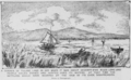
Drawing of a photograph of Tulare Lake from 1875, showing boats and lush surroundings.
-
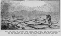
The dry lakebed of Tulare as it appeared in 1898, showing cracked earth.


