Polonio Pass facts for kids
Quick facts for kids Polonio Pass |
|
|---|---|

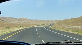
View of the surrounding grasslands from the crest of Polonio Pass.
|
|
| Elevation | 1,407 ft (429 m) |
| Traversed by | Future |
| Location | Kern County |
| Range | Temblor and Diablo Ranges |
| Coordinates | 35°43′25″N 120°11′36″W / 35.723679°N 120.193286°W |
Polonio Pass is a low mountain pass located in California. It acts like a natural gateway between two mountain ranges: the Temblor Range to the south and the Diablo Range to the north. This pass helps connect the wide Central Valley with towns like Shandon and Paso Robles.
The area around Polonio Pass is mostly made up of grassy plains. Highway 46 begins its journey through this narrow mountain opening just a few miles to the west. Polonio Pass is also the southernmost point where you can cross the Diablo Range.
Contents
What is a Mountain Pass?
A mountain pass is like a low spot or a gap in a mountain range. It's often the easiest way to travel from one side of the mountains to the other. Imagine a giant wall of mountains; a pass is a natural door through that wall.
Why are Passes Important?
Passes have been important for thousands of years. They allow people, animals, and even roads to cross difficult terrain. Without passes, traveling across mountains would be much harder and take a lot longer.
Location of Polonio Pass
Polonio Pass is found in Kern County, California. It sits right where the Temblor and Diablo mountain ranges meet. This location makes it a key link for travel in central California.
Connecting Regions
The pass connects the vast Central Valley, which is a major farming area, to the coastal regions. Specifically, it links to towns like Shandon and Paso Robles, which are known for their agriculture and vineyards.
Roads Through the Pass
Several important roads have used or will use Polonio Pass. These roads help people and goods move across the state.
California State Route 46
Today, California State Route 46 (SR 46) travels through Polonio Pass. This highway is a busy route that connects the Central Valley to the Central Coast. It's a vital road for both local traffic and longer journeys.
Historical and Future Routes
Before 1964, U.S. Route 466 also used this pass. In the future, part of Interstate 40 might even use this route. This shows how important Polonio Pass has been and will continue to be for transportation in California.
The Surrounding Landscape
The area around Polonio Pass is quite beautiful. It is surrounded by wide, open grasslands. These grasslands are typical of California's interior regions.
Mountain Ranges
To the south, you'll see the Temblor Range. To the north, the Diablo Range rises up. These ranges are part of California's complex geography. Polonio Pass is a unique spot where these two ranges meet.
 | Misty Copeland |
 | Raven Wilkinson |
 | Debra Austin |
 | Aesha Ash |

