
Exeter, California facts for kids
Quick facts for kids
Exeter, California
|
||
|---|---|---|

CA Hwy 65 through Exeter
|
||
|
||
| Motto(s):
Citrus Capital of the World
|
||

Location of Exeter in Tulare County, California.
|
||

Exeter, California
Location in California

Exeter, California
Location in the United States
|
||
| Country | ||
| State | ||
| County | Tulare | |
| Incorporated | March 2, 1911 | |
| Named for | Exeter | |
| Government | ||
| • Type | Council-Manager | |
| Area | ||
| • City | 2.46 sq mi (6.37 km2) | |
| • Land | 2.46 sq mi (6.37 km2) | |
| • Water | 0.00 sq mi (0.00 km2) 0% | |
| Elevation | 390 ft (119 m) | |
| Population
(2020)
|
||
| • City | 10,321 | |
| • Estimate
(2021)
|
10,324 | |
| • Density | 4,196/sq mi (1,620.3/km2) | |
| • Metro | 473,117 | |
| Time zone | UTC-8 (Pacific) | |
| • Summer (DST) | UTC-7 (PDT) | |
| ZIP code |
93221
|
|
| Area code | 559 | |
| FIPS code | 06-23126 | |
| GNIS feature ID | 1652707 | |

Exeter is a city located in Tulare County, California, in the United States. It's found in the San Joaquin Valley, close to the mountains of the Sierra Nevada. In 2020, about 10,321 people lived there.
Exeter is easy to reach, located right on State Highway 65. It's just 2 miles (3.2 km) south of Highway 198 and 15 miles (24 km) east of Highway 99.
Contents
Welcome to Exeter!
A Look Back: Exeter's History
Early Days and Native People
Long ago, before European settlers arrived, the Yokuts people lived near an oak forest. This forest was about two miles north of where Exeter is today. The area where the town now stands was a flat plain, home to animals like elk, antelope, and deer.
East of the city, there's a place called Rocky Hill. This hill offered a safe place for native tribes when the plains would flood. Some caves on the hill still have ancient rock carvings called petroglyphs.
How Exeter Began
Exeter's story really began with the building of a railroad line. By 1888, a train track passed through this area. A person from the Southern Pacific Railroad, D.W. Parkhurst, bought the land. He bought it from an early settler named John Firebaugh. Parkhurst then created the town and named it after his own hometown, Exeter, England.
Growing Pains and Community Spirit
In the 1930s, dams were built in the Kaweah valley. This helped provide a steady supply of water for farming. Raising cattle also became a big business in the early 1900s. The Gill Cattle Company, which started in the late 1800s, was once the largest cattle business in the United States. Exeter officially became a city in 1911.
In October 1929, Exeter faced a difficult time in its history. A conflict occurred involving Filipino workers, which was a sad moment for the community. This event highlighted challenges faced by different groups of people during that period.
Art Around Town: The Murals
Today, Exeter is famous for its amazing outdoor art gallery. Professional artists have painted huge murals on the outside walls of buildings downtown. These murals show the history of the area. There are currently 31 murals, making the downtown area a vibrant place to explore!
Where is Exeter?
Exeter covers a total area of about 2.5 square miles (6.5 square kilometers). All of this area is land, with no large bodies of water inside the city limits.
Weather in Exeter
| Weather chart for Exeter, California | |||||||||||||||||||||||||||||||||||||||||||||||
|---|---|---|---|---|---|---|---|---|---|---|---|---|---|---|---|---|---|---|---|---|---|---|---|---|---|---|---|---|---|---|---|---|---|---|---|---|---|---|---|---|---|---|---|---|---|---|---|
| J | F | M | A | M | J | J | A | S | O | N | D | ||||||||||||||||||||||||||||||||||||
|
2.4
58
36
|
2.3
65
39
|
2.6
70
42
|
0.9
77
45
|
0.4
85
51
|
0.1
93
57
|
0
98
61
|
0
96
60
|
0.3
91
55
|
0.7
81
47
|
1.3
67
39
|
1.5
58
34
|
||||||||||||||||||||||||||||||||||||
| temperatures in °F precipitation totals in inches source: Weather.com / NWS |
|||||||||||||||||||||||||||||||||||||||||||||||
|
Metric conversion
|
|||||||||||||||||||||||||||||||||||||||||||||||
Exeter has a climate typical of California's Central Valley. Summers are hot and dry, while winters are mild and wet. The chart above shows the average temperatures and rainfall each month. For example, July and August are the hottest months, with very little rain. December and January are cooler and get the most rain.
Who Lives in Exeter?
| Historical population | |||
|---|---|---|---|
| Census | Pop. | %± | |
| 1920 | 1,852 | — | |
| 1930 | 2,685 | 45.0% | |
| 1940 | 3,883 | 44.6% | |
| 1950 | 4,078 | 5.0% | |
| 1960 | 4,264 | 4.6% | |
| 1970 | 4,475 | 4.9% | |
| 1980 | 5,606 | 25.3% | |
| 1990 | 7,276 | 29.8% | |
| 2000 | 9,168 | 26.0% | |
| 2010 | 10,334 | 12.7% | |
| 2020 | 10,321 | −0.1% | |
| 2021 (est.) | 10,324 | −0.1% | |
| U.S. Decennial Census | |||
In 2020, the population of Exeter was 10,321 people. This was a small decrease from the 2010 census, which reported 10,334 residents. The city has grown steadily over the years, from just 1,852 people in 1920.
Many different people make up the community of Exeter. About 45.5% of the population identified as Hispanic or Latino in 2010. The average household in Exeter had about three people living in it.
What Does Exeter Do? (Economy)
Exeter has several important businesses that provide jobs for its residents. Some of the major employers include Waterman Industries, Svenhard's Swedish Bakery, and Peninsula Packaging. These companies help keep the local economy strong.
Learning in Exeter
Exeter has a public school system that serves students from kindergarten through high school.
- Exeter Union High School is for grades 9-12.
- Wilson Middle School teaches grades 6-8.
- Rocky Hill Elementary and Lincoln Elementary are for younger students in grades K-5.
- Kaweah High School is a continuation high school, offering another option for students.
In the 1999-2000 school year, there were about 1,936 students in grades K-8 and 1,101 students in grades 9-12.
Famous Faces from Exeter
Many interesting people have connections to Exeter:
- William DeGrado is an entrepreneur and biochemist who was born in Exeter.
- Kenny Guinn was a former governor of Nevada.
- Satoshi Hirayama was a baseball star for the Hiroshima Toyo Carp, born and raised in Exeter.
- Robert List also served as a former governor of Nevada.
- Brad Mills is a former player and coach in Major League Baseball.
- Jim Qualls was a former Major League Baseball outfielder for the Chicago Cubs.
- Jeriome Robertson was a baseball pitcher for the Houston Astros and Cleveland Indians. He grew up and passed away in Exeter.
- Ron Robinson was a Major League Baseball pitcher for the Cincinnati Reds and the Milwaukee Brewers.
Gallery
-
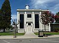
The Exeter Historical Museum is housed in the old Mt. Whitney Power Company Substation, formerly the headquarters of the Exeter Police Department.
-
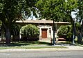
The Exeter Public Library building, a Carnegie library, is on the National Register of Historic Places; it now serves as a community center.
-
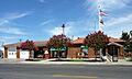
City Hall and Fire Department


See also
 In Spanish: Exeter (California) para niños
