Fresno River facts for kids
Quick facts for kids Fresno River |
|
|---|---|

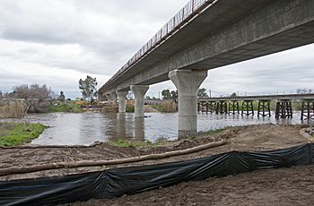
Fresno River Viaduct, February 2017
|
|
| Country | United States |
| State | California |
| Physical characteristics | |
| Main source | Confluence of Lewis Fork Creek, Nelder Creek, and China Creek Oakhurst, Madera County 2,510 ft (770 m) 37°21′43″N 119°37′58″W / 37.36194°N 119.63278°W |
| River mouth | San Joaquin River Near Dos Palos, Madera County 108 ft (33 m) 37°04′32″N 120°33′39″W / 37.07556°N 120.56083°W |
| Length | 68 mi (109 km) |
| Basin features | |
| Tributaries |
|
The Fresno River is an important river in Central California. It flows for about 68 miles (109 km) from the Sierra Nevada mountains all the way to the San Joaquin River. Even though it's called the 'Fresno' River, it's actually one of the biggest and longest rivers in Madera County.
Contents
Journey of the Fresno River
Where the River Starts
The Fresno River begins in the Oakhurst valley. Its main source is Lewis Fork Creek, which collects water from the hills near Fish Camp. Another important stream, Nelder Creek, also feeds into Lewis Fork Creek. China Creek adds water from the ridges around Teaford Saddle.
Flowing Through the Foothills
After Oakhurst, the Fresno River flows northwest. It then carves its way through hills, creating winding canyons. This area was somewhat popular during the California Gold Rush in the 1850s. As the river leaves the hills, the canyons become wider. It crosses Road 415 at a spot known as the Fresno Crossing.
Hensley Lake: A Popular Spot
Once the river leaves the foothills, it flows into a gently sloped valley. Here, the Hidden Dam was built, creating Hensley Lake. This lake is a popular place for fun activities. When snow melts in the spring, the lake fills up and covers a large area.
Journey to the San Joaquin River
Below Hensley Lake, the river flows southwest towards Madera. Then it turns west to join the Eastside Bypass. After leaving the bypass, the river generally flows northwest. It finally meets the San Joaquin River just north of Highway 152.
Lakes and Dams Along the River
Hidden Dam is the only major dam on the Fresno River. This dam creates Hensley Lake, a large reservoir that can hold about 90,000 acre-feet (111 million cubic meters) of water. The United States Army Corps of Engineers built this dam, finishing it in 1974.
Purpose of Hidden Dam
The main reason for Hidden Dam is to control floods. It also helps manage water for irrigation (watering crops) and to refill groundwater (water stored underground). Since 1978, Hensley Lake has been open to the public. It's a favorite spot for boating and fishing for people living nearby.
Other Water Features
Below Hidden Dam, the Fresno River provides water to Madera Lake through a small channel. Any extra water from Madera Lake flows back into the Fresno River. Further downstream, near Madera, is the John Franchi Diversion Dam. This dam is 15 feet (4.6 m) high and 263 feet (80 m) wide. It helps send water into the Big Main Canal.
The United States Bureau of Reclamation built the John Franchi Diversion Dam in 1964. It is managed by the Madera Irrigation District. After this dam, the river is usually dry. Water only flows past it when water levels are very high and spill over the dam.
How People Changed the Lower River
West of Road 17 in Madera County, people have changed the Fresno River's natural path a lot. The original riverbed now has many gaps. These gaps are connected by canals that people built.
At Road 17, the riverbed was changed to send most of the water into a man-made canal. This canal leads to the Eastside Bypass. Water can also flow down the original river channel, but it eventually ends up in the bypass too.
Once in the bypass, water can leave through a small channel at a dam. It then continues west along the natural riverbed to the San Joaquin River. This part of the riverbed is almost always dry. It has been straightened in some places, but it mostly follows its original path.
Streams Joining the River
Many smaller streams flow into the Fresno River. Here are some of the main ones:
- Oak Creek
- China Creek
- Miami Creek
- Crooks Creek
- Spangle Gold Creek
- Willow Creek
- Mud Spring Creek
- China Slough
- South Fork Fresno River (This stream branches off and then returns to the main river.)
- Berenda Slough
Towns Along the Fresno River
The Fresno River flows near these towns:
River Crossings
Many roads and bridges cross the Fresno River in Madera and Merced Counties. Here are some of them, listed from where the river starts to where it ends:
Crossings Above Hensley Lake
- Crane Valley Road (Road 426)
- State Route 41
- River View Drive
- Dupfy Fire Road (Road 8084)
- Ellerbrock Station Road
- Raymond Road (Road 415)
Crossings Below Hensley Lake (Madera County)
- Daulton Road (Road 603)
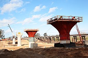
- California High-Speed Rail Fresno River Viaduct (This bridge is currently being built.)
Crossings in the City of Madera
- East Cleveland Avenue
- North Lake Street
- North D Street
- North Gateway Drive
- State Route 99
- Schnoor Avenue
- North Granada Drive
Crossings Below Madera (Madera County)
- Road 23
- Road 20
- Road 19
- Road 16
- Road 9
- Road 1
Crossings in Merced County
 | Charles R. Drew |
 | Benjamin Banneker |
 | Jane C. Wright |
 | Roger Arliner Young |


