Lathrop, California facts for kids
Quick facts for kids
Lathrop, California
|
|
|---|---|

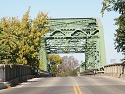
San Joaquin River road bridge at Mossdale Crossing in Lathrop
|
|

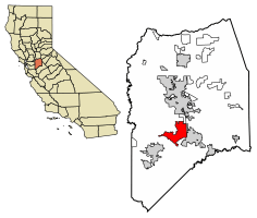
Location of Lathrop in San Joaquin County, California
|
|
| Country | United States |
| State | California |
| County | San Joaquin |
| Incorporated | July 1, 1989 |
| Area | |
| • Total | 21.01 sq mi (54.41 km2) |
| • Land | 19.83 sq mi (51.35 km2) |
| • Water | 1.18 sq mi (3.06 km2) 4.79% |
| Elevation | 23 ft (7 m) |
| Population
(2020)
|
|
| • Total | 28,701 |
| • Density | 1,366.1/sq mi (527.49/km2) |
| Time zone | UTC-8 (PST) |
| • Summer (DST) | UTC-7 (PDT) |
| ZIP code |
95330
|
| Area code(s) | 209 |
| FIPS code | 06-40704 |
| GNIS feature ID | 1658948 |
Lathrop (/ˈleɪθrəp/, LAY-thrəp) is a city in San Joaquin County, California, United States. It is about 10 miles (16 km) south of Stockton. In 2020, about 28,701 people lived there.
Lathrop is in Northern California. It sits where two major roads meet: Interstate 5 and California State Route 120. The city is part of the San Joaquin Valley.
Contents
History of Lathrop
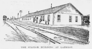
Lathrop started because of railroads. The town began around 1868. This was when the first transcontinental railroad was being built. The Central Pacific Railroad wanted to build through Stockton. But city officials took too long to decide where the tracks should go.
So, Leland Stanford, the railroad president, decided to build around Stockton. He created a new town along the tracks instead. This new town was planned with 16 sections. It was built around a train station called Wilson's Station. This station had a "wye," which is a Y-shaped track for turning trains around.
Soon after, a store and a school were built. In 1869, the area was renamed Lathrop. This honored the family of Leland Stanford's wife, Jane Stanford (her maiden name was Lathrop). Her brother, Charles Lathrop, also worked for the railroad.
Railroad Importance
On September 6, 1869, a big event happened. The San Joaquin Railroad Bridge at Mossdale Crossing in Lathrop was finished. This bridge completed the last part of the transcontinental railroad to the Pacific coast. The first train arrived that evening. This made Lathrop a very important stop for trains.
In 1871, Lathrop got a post office. The railroad also built a large hotel called Hotel Lathrop. It cost $50,000 and was one of the biggest hotels in California at the time.
Throughout the 1870s, Lathrop grew steadily. Its population reached about 600 people by 1879. This growth was thanks to its role as a key rail stop.
Changes and Growth
In February 1886, the railroad's hotel burned down. Around the same time, the railroad moved its repair shops to nearby Tracy, California. These changes caused Lathrop to shrink for a while. It did not start growing again until World War I.
On August 14, 1889, a famous event happened at the Lathrop train station. A former California judge, David S. Terry, had an argument with a U.S. Supreme Court Justice, Stephen J. Field. Justice Field's bodyguard, David Neagle, shot and killed Terry. This event led to an important U.S. Supreme Court decision. It said that federal officers are protected from state charges when doing their federal duties.
During the 1940s, Lathrop grew bigger. After World War II, many new homes were built. Also, several large companies moved to the area. Growth slowed in the 1950s and 1960s. But it picked up again later. The population doubled to 2,137 in 1970. By 1990, it reached 6,841 people.
Lathrop officially became a city in 1989. Its first city plan was approved in 1991.
Geography of Lathrop
The San Joaquin River flows through the middle of Lathrop. The Old River (California) is on the west side. The city is about 20 feet (7 meters) above sea level.
Nearby Cities
Lathrop is close to several other cities and towns. These include Stockton, Manteca, Ripon, French Camp, and Tracy.
The city covers about 23.0 square miles (59.6 square kilometers). About 1.1 square miles (2.8 square kilometers) of this area is water.
Population and People
| Historical population | |||
|---|---|---|---|
| Census | Pop. | %± | |
| 1890 | 577 | — | |
| 1960 | 1,123 | — | |
| 1970 | 2,137 | 90.3% | |
| 1980 | 3,717 | 73.9% | |
| 1990 | 6,841 | 84.0% | |
| 2000 | 10,445 | 52.7% | |
| 2010 | 18,023 | 72.6% | |
| 2020 | 28,701 | 59.2% | |
| 2023 (est.) | 39,857 | 121.1% | |
| U.S. Decennial Census | |||
In 2010, Lathrop had 18,023 people. Most people lived in homes. Only a very small number lived in group homes or institutions.
Many households (57.3%) had children under 18. Most households (62.2%) were married couples. The average household had 3.77 people. The average family had 3.99 people.
About 32.3% of the people were under 18. About 6.5% were 65 or older. The average age was 30.5 years. For every 100 females, there were about 99.7 males.
Most homes (75.4%) were owned by the people living in them. The rest (24.6%) were rented.
Economy and Jobs
Lathrop has many jobs, especially in manufacturing and shipping. Here are some of the top employers in the city:
| # | Employer | # of employees |
|---|---|---|
| 1 | Tesla, Inc. | 3,000 |
| 2 | United Parcel Service | 1,500 |
| 3 | Pflug Packaging | 450 |
| 4 | Army & Air Force Exchange Service | 400 |
| 5 | Wayfair | 400 |
| 6 | Super Store Industries | 375 |
| 7 | California Natural Products | 375 |
| 8 | Simwon America | 336 |
| 9 | Manteca Unified School District | 333 |
| 10 | CBC Steel Buildings | 203 |
Major Companies in Lathrop
Lathrop is a good place for businesses. Many people live within 7 miles (11 km) of the city. Their average household income is about $63,072.
Lathrop is located between the Stockton and Tracy business areas. Both are within 20 miles (32 km).
In 2014, the electric car company Tesla opened a large warehouse in Lathrop. It was in a 430,000 square foot (40,000 square meter) building. This building used to be a Chrysler distribution center. Tesla also has a factory in Lathrop. It builds large lithium-ion battery containers called Megapacks. Tesla is now Lathrop's biggest employer.
New Neighborhoods and Parks
Lathrop has seen many new building projects.
- Mossdale Village: This neighborhood has 2,375 homes. It is west of I-5 and east of the San Joaquin River. It is named after the historic Mossdale Crossing. This was where the last part of the Transcontinental Railroad was finished in 1869. You can find a California State Historical Marker (number 781-7) at Mossdale Crossing Park.
- Stanford Crossing: This is a large planned community with 2,167 lots. It is also west of I-5 and east of the San Joaquin River. The community's name honors Leland Stanford. He was important in finishing the transcontinental railroad nearby. A park in this area is named Leland and Jane Stanford Park. It is 4.13 acres (1.67 hectares) big.
These plans also set aside land for important community buildings. These include the Lathrop Generations Center and Lathrop High School.
Education in Lathrop
Most of Lathrop is served by the Manteca Unified School District. However, the River Islands area, west of Interstate 5, has public charter schools. These schools are part of the Banta Unified School District.
Elementary Schools
Manteca Unified School District has three elementary schools in Lathrop. They are Joseph Widmer Jr, Lathrop School, and Mossdale School. Students in the River Islands area go to three public charter elementary schools.
High Schools
Lathrop High School was the first high school in Lathrop. It opened in 2008 and is part of Manteca Unified School District. The school has a famous Spartan band. They have performed at Cal Band Day at Cal Berkeley. The music program includes concert band, symphonic band, marching band, and drum line.
A second high school, River Islands High School, opened in 2024. It is part of the Banta Unified School District.
Transportation
The City of Lathrop has public transportation options. The San Joaquin Regional Transit District provides bus services. The Altamont Corridor Express commuter train also stops at the Lathrop/Manteca station.
Sister cities
 Bacarra, Ilocos Norte, Philippines
See also
 In Spanish: Lathrop (California) para niños
 | Laphonza Butler |
 | Daisy Bates |
 | Elizabeth Piper Ensley |


