Old River (California) facts for kids
Quick facts for kids Old River |
|
|---|---|

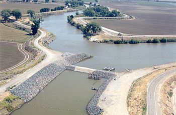
Old River (below) at upper confluence with San Joaquin River near Tracy
|
|
| Country | United States |
| State | California |
| Physical characteristics | |
| Main source | San Joaquin River Lathrop 11 ft (3.4 m) 37°48′29″N 121°19′38″W / 37.80806°N 121.32722°W |
| River mouth | San Joaquin River near Terminous Sea level 38°04′21″N 121°34′15″W / 38.07250°N 121.57083°W |
| Length | 40 mi (64 km) |
The Old River is a waterway in Northern California. It is a branch of the San Joaquin River. It flows for about 40 miles (64 km) through the Sacramento–San Joaquin River Delta.
Long ago, the Old River was the main path for the San Joaquin River. But in the late 1800s and 1900s, projects were built. These projects helped control floods and make it easier for ships to travel. Because of this, the San Joaquin River now flows mainly past Stockton.
The Old River starts near Tracy. This is about 38 miles (61 km) upstream from Antioch. It first flows west towards Mountain House. Then it turns north. It joins the San Joaquin River again about 13 miles (21 km) above Antioch.
Contents
What is the Old River?
The Old River is a special kind of river branch called a distributary. This means it branches off a larger river. It is also a tidal river. This means its water levels change with the ocean tides.
How Does the Old River Flow?
The river is surrounded by high walls called levees. These levees stop the water from flooding nearby Delta islands. Many of these islands are actually lower than the sea!
Another river, the Middle River, runs next to the Old River. It is to the east and flows in a similar direction. The False River also branches off the Old River. It flows west to join the San Joaquin River closer to Antioch.
Part of the Old River forms a border. It separates San Joaquin County on the east from Contra Costa County on the west.
How Deep and Wide is the Old River?
The Old River is usually 5 to 10 feet (1.5 to 3 meters) deep. It can be anywhere from 150 feet (46 meters) to 1,600 feet (488 meters) wide.
Old River and California's Water Supply
The Old River plays a very important role in California's water supply. About halfway along its path, it passes by the Clifton Court Forebay. This is a large storage area. Water is pumped from the Delta here. This water then goes into two big water supply systems. These are the Central Valley Project and the State Water Project.
Why Does the River Flow Backwards?
These water projects get their main water from the Sacramento River further north. When water is pumped from the Delta, it creates a pull. This pull makes the water in the Old River flow backwards! Normally, the Old River would flow north. But the pumping pulls water south through the Delta and up the Old River.
During dry summers, this can cause problems. Saltwater from San Francisco Bay can get pulled into the river. This is called saltwater intrusion. It makes the water too salty.
How Does the Old River Affect Salmon?
The backwards flow also confuses migrating salmon. Salmon are fish that swim from the ocean back to the rivers to lay their eggs. When the river flows backwards, young salmon can get lost. They might enter the longer, winding Old River. This makes it harder for them to survive their journey to the sea. This problem has contributed to fewer salmon over the years.
Since the 1960s, the California Department of Water Resources has tried to help. They put up temporary barriers to control the water flow. This has made the water cleaner and helped it move better.
One important barrier is the Head of Old River barrier. It is put in place each spring. This barrier is where the Old River splits from the San Joaquin. It stops young salmon from going into the Old River. This helps them find their way safely to the ocean.
Water for Los Vaqueros Reservoir
There is also a pumping station on the Old River. It is east of Discovery Bay. This station pumps fresh water through a pipe to the Los Vaqueros Reservoir.
Islands Along the Old River
Many islands are located along the Old River.
- On the right side of the river, you can find:
- Berts Island
- Union Island
- Victoria Island
- Woodward Island
- Bacon Island
- Mandeville Island
- On the left side of the river, you can find:
- Stewart Tract
- Coney Island
- Widdows Island
- Byron Tract
- Orwood Tract
- Palm Tract
- Holland Tract
- Little Mandeville Island
- Quimby Island
- Webb Tract
The Old River also goes past the Franks Tract State Recreation Area. This used to be a Delta island. Now it is underwater and forms a lake.
Monitoring the Old River
The U.S. Geological Survey (USGS) keeps an eye on the Old River. They have five special tools called stream gauges. These tools measure how much water is flowing. For example, at Bacon Island, the Old River had an average reverse flow of about 1,824 cubic feet per second (51.6 cubic meters per second) between 2006 and 2014. This shows how much water was being pulled backwards.
 | John T. Biggers |
 | Thomas Blackshear |
 | Mark Bradford |
 | Beverly Buchanan |

