Victoria Island (California) facts for kids

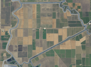
USGS aerial imagery of Victoria Island
|
|
| Geography | |
|---|---|
| Location | Northern California |
| Coordinates | 37°53′24″N 121°32′05″W / 37.889925°N 121.534672°W |
| Adjacent bodies of water | Sacramento-San Joaquin River Delta |
| Area | 7,200 acres (2,900 ha) |
| Administration | |
| State | |
| County | San Joaquin |
Victoria Island is an island located in the Sacramento-San Joaquin River Delta in Northern California. It's about 20 kilometers (or 12 miles) southwest of the city of Stockton. This island is quite large, covering about 7,200 acres!
The island is surrounded by different waterways. The North Victoria Canal is to its north. The Middle River runs along its northeast side. To the southeast, you'll find the Victoria Canal. Finally, the Old River forms its southern and southwestern borders.
A main road, California State Route 4, crosses the island. Victoria Island is part of San Joaquin County. It is managed by a group called Reclamation District 2040.
What's Hiding Under Victoria Island?
Oil exploration is when people look for oil deep underground. During this search, something interesting was found under Victoria Island. Scientists discovered what might be a buried impact structure.
What is an Impact Structure?
An impact structure is like a giant dent or bowl shape in the Earth's surface. It's made when a large object from space, like a meteorite, crashes into our planet. Over time, these structures can get buried under layers of dirt and rock.
This specific structure was named the Victoria Island Structure after the island above it. It's a cool reminder of how Earth's history can be hidden right beneath our feet!
 | Sharif Bey |
 | Hale Woodruff |
 | Richmond Barthé |
 | Purvis Young |


