
Porterville, California facts for kids
Quick facts for kids
Porterville, California
|
|||
|---|---|---|---|
| City of Porterville | |||

The Porterville Historical Museum
|
|||
|
|||
| Nickname(s):
P'ville,, BandTown USA, Gateway to the Sequoia National Monument Po'ville
|
|||

Location of Porterville in Tulare County and the U.S. state of California
|
|||

Porterville, California
Location in California

Porterville, California
Location in the United States
|
|||
| Country | United States | ||
| State | California | ||
| County | Tulare
|
||
| CSA | Visalia-Porterville-Hanford | ||
| Metro | Visalia-Porterville | ||
| Incorporated | May 7, 1902 | ||
| Government | |||
| • Type | Charter city, Council-Manager | ||
| Area | |||
| • City | 18.66 sq mi (48.34 km2) | ||
| • Land | 18.61 sq mi (48.20 km2) | ||
| • Water | 0.06 sq mi (0.14 km2) 0.41% | ||
| • Metro | 4,839 sq mi (12,530 km2) | ||
| Elevation | 459 ft (140 m) | ||
| Population
(2020)
|
|||
| • City | 62,742 | ||
| • Density | 3,362.4/sq mi (1,297.93/km2) | ||
| • Metro | 459,446 | ||
| • Metro density | 94.946/sq mi (36.659/km2) | ||
| Demonym(s) | Portervillian | ||
| Time zone | UTC−8 (Pacific) | ||
| • Summer (DST) | UTC−7 (PDT) | ||
| ZIP codes |
93257–93258, 93265, 93267, 93270, 93260
|
||
| Area code(s) | 559 | ||
| FIPS code | 06-58240 | ||
| GNIS feature IDs | 1652779, 2411470 | ||


Porterville is a city in Tulare County, California, United States. It is located at the base of the Southern Sierra Nevada mountains, on the eastern side of the San Joaquin Valley. Porterville is part of the Visalia-Porterville metropolitan area.
The city is known as a gateway to beautiful natural areas. These include the Sequoia National Forest, Giant Sequoia National Monument, and Kings Canyon National Park. You can enjoy outdoor activities like hiking, camping, and fishing there.
Porterville was officially made a city in 1902. Since then, it has grown by adding nearby areas. In 2020, the city's population was about 62,623 people.
Contents
- The Story of Porterville: How It Began
- The Tule River Indian War of 1856
- Geography and Climate
- Population and People
- Economy and Jobs
- Famous People from Porterville
- Getting Around Porterville: Transportation
- News and Media
- Education and Schools
- Courts and Public Services
- Sister Cities
- Images for kids
- See also
The Story of Porterville: How It Began
The area where Porterville is now was once considered a quiet, remote place. Early travelers passed through as far back as 1826. The valley floor was very wet, with many tall rushes that local Indigenous people called "tulare."
Gold Rush and Early Settlements
When gold was found in California in 1848, many people moved there. Wagon trains of gold seekers traveled through the Porterville area between 1849 and 1852. In 1854, a man named Peter Goodhue set up a stopping place for travelers. It was on the Stockton - Los Angeles Road, next to the Tule River.
A store opened in 1856 to sell goods to miners and Native Americans. From 1858 to 1861, this spot was also a stop for the Butterfield Overland Mail service.
Royal Porter Putnam and the City's Founding
In 1860, Royal Porter Putnam arrived. He bought Goodhue's stopping place and turned it into a popular hotel called Porter Station. He bought 40 acres of land and built a two-story store and hotel. This was on the highest part of the land, which is now the corner of Oak and Main streets.
The town of Porterville was founded there in 1864. It was named after Royal Porter Putnam's middle name. This was done because another Putnam family lived south of town.
Growth and Development
In 1862, heavy rains caused the Tule River to change its path. This drained Putnam's land, allowing him to plan streets and lots. He offered free land to settlers who bought a lot. This helped the town grow.
The Southern Pacific Railway arrived in 1888, connecting Porterville to Fresno. More businesses, like the Pioneer Hotel and a bank, were built. Porterville officially became a city in 1902.
Over the years, farming, especially citrus fruits and livestock, has been very important to Porterville's economy. The city also has large businesses and public facilities. These include a Walmart Distribution Center, the Sequoia National Forest Headquarters, and Porterville College.
In March 2023, Porterville faced severe flash floods. The National Weather Service issued several flash flood warnings for the city.
The Tule River Indian War of 1856
Native American tribes lived peacefully in the Sierra Nevada foothills. However, when gold was discovered in the 1840s and 1850s, miners began moving onto their lands. A treaty was signed in 1851, but the US Senate did not approve it.
Conflict and Its Aftermath
In 1856, a rumor spread that Native Americans had stolen cattle. It turned out only one calf had been taken as a gift. Despite this, groups of armed settlers attacked Native camps.
One group of settlers was pushed back by the Native Americans. Reinforcements arrived, but they were also repelled. The settlers then destroyed Native American food supplies.
News of these events spread, making the situation seem worse than it was. In May 1856, army troops attacked the Native encampment, forcing the defenders to leave. The conflict lasted about six weeks.
Historians later noted that the war could have been avoided if settlers had wanted peace. They also pointed out that the Native Americans were not well-armed.
Geography and Climate
Porterville is located at 36°4′7″N 119°1′39″W / 36.06861°N 119.02750°W. The city covers about 17.7 square miles (45.8 square kilometers). Most of this area is land, with a small amount of water.
Location and Surroundings
Porterville is on the Tule River, at the base of the western Sierra Nevada foothills. It's also in the eastern part of California's Central Valley. Above the city, you'll find Lake Success, a man-made lake.
The city is about 165 miles (266 km) north of Los Angeles. It is also 171 miles (275 km) east of the Pacific Coast. Its location on State Highway 65 makes it easy to reach major markets.
Understanding Porterville's Climate
Porterville has a climate that is mostly dry and warm. Summers are very hot and dry. Winters are pleasant, with cold mornings and some rain.
| Climate data for Porterville, California | |||||||||||||
|---|---|---|---|---|---|---|---|---|---|---|---|---|---|
| Month | Jan | Feb | Mar | Apr | May | Jun | Jul | Aug | Sep | Oct | Nov | Dec | Year |
| Mean daily maximum °F (°C) | 57.9 (14.4) |
63.7 (17.6) |
69.6 (20.9) |
76.7 (24.8) |
84.0 (28.9) |
92.4 (33.6) |
100.5 (38.1) |
98.3 (36.8) |
92.9 (33.8) |
81.4 (27.4) |
69.6 (20.9) |
58 (14) |
78.7 (25.9) |
| Mean daily minimum °F (°C) | 35.6 (2.0) |
39.1 (3.9) |
42.1 (5.6) |
46.3 (7.9) |
51.8 (11.0) |
57.6 (14.2) |
63.7 (17.6) |
61.8 (16.6) |
56.2 (13.4) |
49.5 (9.7) |
40.7 (4.8) |
36.8 (2.7) |
48.4 (9.1) |
| Average rainfall inches (mm) | 2.17 (55) |
1.99 (51) |
2.33 (59) |
1.0 (25) |
0.5 (13) |
0.14 (3.6) |
0.01 (0.25) |
0.02 (0.51) |
0.35 (8.9) |
0.65 (17) |
1.14 (29) |
1.77 (45) |
12.07 (307.26) |
| Average rainy days (≥ 0.01 in) | 7.2 | 6.9 | 6.3 | 2.8 | 1.6 | 0.4 | 0.3 | 0.3 | 1.7 | 1.7 | 3.9 | 5.4 | 38.5 |
| Source: NOAA | |||||||||||||
Environmental Concerns and Air Quality
Because of its location and the use of cars and farming, Porterville can have air pollution (smog). The San Joaquin Valley often experiences "atmospheric inversion." This traps exhaust from vehicles, farms, and factories close to the ground.
Unlike other cities that get a lot of rain to clear the air, Porterville only gets about 13 inches (330 mm) of rain each year. This means pollution can build up for many days. Efforts like the Clean Air Act and California's rules for low-emission vehicles have helped.
Pollution levels have improved a lot in recent years. The number of serious smog alerts has dropped significantly. However, Porterville still faces challenges with air quality.
The area has also been affected by California's extreme drought. Many private wells in nearby East Porterville have run out of water. Porterville has sent bottled water to help.
Population and People
| Historical population | |||
|---|---|---|---|
| Census | Pop. | %± | |
| 1880 | 202 | — | |
| 1890 | 606 | 200.0% | |
| 1910 | 2,696 | — | |
| 1920 | 4,097 | 52.0% | |
| 1930 | 5,303 | 29.4% | |
| 1940 | 6,270 | 18.2% | |
| 1950 | 6,904 | 10.1% | |
| 1960 | 7,991 | 15.7% | |
| 1970 | 12,602 | 57.7% | |
| 1980 | 19,707 | 56.4% | |
| 1990 | 29,563 | 50.0% | |
| 2000 | 39,615 | 34.0% | |
| 2010 | 54,165 | 36.7% | |
| 2020 | 62,623 | 15.6% | |
| U.S. Decennial Census | |||
Porterville's Population in 2010
In 2010, Porterville had a population of 54,165 people. About 97.9% of the people lived in homes.
The city is very diverse. About 58.8% of the population was White, 1.2% African American, 1.9% Native American, and 4.7% Asian. About 28.6% were from other races, and 4.7% were from two or more races. A large part of the population, 61.9%, identified as Hispanic or Latino.
There were 15,644 households in Porterville. Many households (52.3%) had children under 18 living there. The average household had 3.39 people.
The population included people of all ages. About 33.5% were under 18, and 9.4% were 65 or older. The average age in the city was 28.8 years.
Porterville's Population in 2000
In 2000, the city's population was 39,615. There were 11,884 households.
The racial makeup was 49.8% White, 1.3% African American, 1.7% Native American, and 4.6% Asian. About 32.7% were from other races, and 4.8% were from two or more races. Hispanic or Latino people made up 54.5% of the population.
Many households (47.5%) had children under 18. The average household size was 3.20 people.
The population was spread out by age. About 34.3% were under 18, and 9.4% were 65 or older. The average age was 29 years.
The median income for a household was $32,046. About 25.7% of the population lived below the poverty line.
Economy and Jobs
Porterville has a strong economy, with many different types of jobs.
Major Employers in Porterville
Here are some of the biggest employers in the city, based on a 2020 report:
| # | Employer | # of employees |
|---|---|---|
| 1 | Porterville Unified School District | 1,606 |
| 2 | Porterville Developmental Center | 1,169 |
| 3 | Walmart Distribution Center | 1,054 |
| 4 | Sierra View District Hospital | 833 |
| 5 | Burton School District | 685 |
| 6 | City of Porterville | 574 |
| 7 | Eagle Mountain Casino | 460 |
| 8 | Foster Farms | 387 |
| 9 | Family Healthcare Network | 303 |
| 10 | Walmart Store | 298 |
Famous People from Porterville
Many notable individuals have connections to Porterville:
- Barbara Baxley (1923–1990) – An actress who appeared in films, on stage, and on television.
- Brant Brown – A former Major League Baseball outfielder for teams like the Chicago Cubs.
- Tex Clevenger – A former Major League Baseball pitcher for teams like the Boston Red Sox.
- Allen Drury – A novelist who won the Pulitzer Prize in 1960.
- Vernon Grant – An artist famous for creating the Kellogg's characters Snap, Crackle, and Pop. He graduated from Porterville High School in 1921.
- Sim Iness – An Olympic gold medalist in the discus throw.
- Michel Moore – The Chief of Police for the Los Angeles Police Department (LAPD).
- Rance Mulliniks – A former Major League Baseball infielder for teams like the Toronto Blue Jays.
- Rick Owens – A well-known fashion designer.
- Bear Pascoe – A football player who played for the NFL's New York Giants.
- Bill Sharman – An NBA Hall of Fame player and coach.
- Kirsten Vangsness – An actress known for her role in the TV show Criminal Minds.
Getting Around Porterville: Transportation
Porterville has several ways to get around, including highways, public buses, and an airport.
Highways and Major Roads
 State Route 65: This is a main north-south road, also called the All-American City Highway or Porterville Freeway. It goes north to Lindsay and south to Bakersfield.
 State Route 190: This is a main east-west road. It goes west to California State Route 99 in Tipton and east to Springville.
Porterville also has several county roads that help people travel within and around the city.
Public Transportation Options
Porterville Transit offers bus services that are good for the environment. They serve Porterville and nearby communities. There's also Porterville COLT Paratransit for people with disabilities. In 2020, the city started the transPORT service, which is like on-demand ride-sharing.
Tulare County Area Transit (TCaT) connects Porterville to smaller towns. They offer bus and on-demand services Monday through Saturday.
Air Travel in Porterville
Porterville has its own airport, the Porterville Municipal Airport. It offers charter flights for passengers.
Larger commercial airports nearby include:
- (IATA: FAT, ICAO: KFAT, FAA LID: FAT) Fresno Yosemite International Airport: This airport serves the wider San Joaquin Valley.
- (IATA: BFL, ICAO: KBFL, FAA LID: BFL) Meadows Field Airport: This airport serves the southern part of the San Joaquin Valley and the Bakersfield area.
Future Airport Improvements
The City of Porterville received a $4.44 million grant to improve its airport. This money will help fix the taxiway and change some connecting taxiways. These upgrades will make the airport better and safer.
Future plans include making the runway longer, from about 6,000 feet to 7,800 feet. This will allow larger jet aircraft to use the airport.
Rail Transportation History
Porterville used to have a train station on the Southern Pacific's Exeter Branch line. This line was later sold. By 2010, the train tracks had been removed.
The city has bought the old train path. Eventually, new tracks will be laid as part of the Cross Valley Corridor project.
News and Media
Newspapers
The Porterville Recorder is the daily newspaper for the greater Porterville area.
Radio Stations
You can listen to several radio stations in Porterville:
- KIOO (99.7 FM)
- K289AZ (105.7 FM)
- KMQA (100.5 FM)
- KTIP (1450 AM)
Television Stations
TV stations KTFF-DT and KVVG-LP are licensed to Porterville.
Education and Schools
Most of Porterville is served by the Porterville Unified School District. Some parts of the western city are in the Burton Elementary School District.
Schools in Porterville Unified School DistrictElementary Schools
Middle Schools
High Schools
Alternative High Schools
Adult Schools
|
Schools in Burton School DistrictElementary Schools
Middle Schools
High Schools
Alternative Schools
|
Higher Education Opportunities
Porterville has one community college, Porterville College (PC). National University also has a learning center there.
In 2017, San Joaquin Valley College (SJVC) opened a branch in Porterville.
Courts and Public Services
Porterville is home to several important public offices.
- Tulare County - District Attorney's Office - 16 East Olive Avenue
- Social Security Administration - Office - 890 West Morton Avenue
South County Justice Center
The South County Justice Center is a modern courthouse in Porterville. It has nine courtrooms and is 96,000 square feet. This new building replaced an older, crowded courthouse.
The center was designed to be energy-efficient and environmentally friendly. It uses special glass, insulated walls, and efficient lighting. It also has features like low-water fixtures and green roofs.
The project was funded by the state of California. This helps ensure that court facilities are modern and accessible.
Sister Cities
Porterville has "sister cities," which are partnerships with other communities to promote cultural ties.
- Strathmore
- Lindsay
Images for kids
-
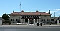
The Porterville Historical Museum occupies the old Southern Pacific Railroad depot, constructed in 1913.
-
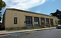
The Porterville Main post office is one of three Porterville structures on the National Register of Historic Places (NRHP).
-
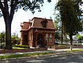
The NRHP-listed Zalud House is a former private home, now a museum.
-

The First Congregational Church is also listed on the NRHP.


See also
 In Spanish: Porterville (California) para niños
