Esmeralda County, Nevada facts for kids
Quick facts for kids
Esmeralda County
|
|||
|---|---|---|---|
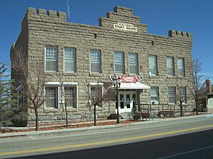
Esmeralda County Courthouse in Goldfield
|
|||
|
|||
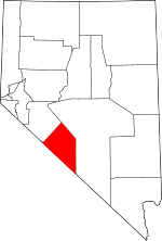
Location within the U.S. state of Nevada
|
|||
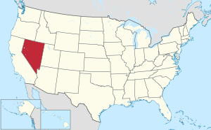 Nevada's location within the U.S. |
|||
| Country | |||
| State | |||
| Founded | November 25, 1861 | ||
| Named for | Emerald | ||
| Seat | Goldfield | ||
| Largest community | Dyer | ||
| Area | |||
| • Total | 3,589 sq mi (9,300 km2) | ||
| • Land | 3,582 sq mi (9,280 km2) | ||
| • Water | 7.2 sq mi (19 km2) 0.2% | ||
| Population
(2022)
|
|||
| • Total | 744 | ||
| • Density | 0.20730/sq mi (0.08004/km2) | ||
| Time zone | UTC−8 (Pacific) | ||
| • Summer (DST) | UTC−7 (PDT) | ||
| Congressional district | 4th | ||
Esmeralda County is a county located in the southwestern part of Nevada, a U.S. state. As of 2023, it has about 736 people. This makes it the county with the fewest people in Nevada. It is also one of the least populated counties in the entire United States.
Esmeralda County does not have any official cities or towns. Its main town, called the county seat, is Goldfield. Most people in the county live in Goldfield or in the town of Dyer. Dyer is located in Fish Lake Valley, close to the California border.
One interesting fact is that Esmeralda County does not have its own high school. Students in grades 9-12 travel to Tonopah for school. Tonopah is in the neighboring Nye County School District.
Contents
History of Esmeralda County
Esmeralda County is one of Nevada's first counties. It was created on November 25, 1861. The name Esmeralda means "emerald" in Spanish and Portuguese. An early miner named the area after Esmeralda, a dancer from the famous book The Hunchback of Notre-Dame.
When the county was first formed, much of its land was unexplored. John C. Frémont was one of the first to explore parts of the county in 1845. Later, in the 1860s, explorers found silver in the area. This led to the creation of new mining towns and ranches.
Over time, the size of Esmeralda County changed. In 1864, a large part of its land was used to create Nye County. Esmeralda County has had three different county seats. These were Aurora until 1883, Hawthorne from 1883 to 1907, and finally Goldfield. At one point, Aurora was even the county seat for two different counties at the same time because of a border dispute! The famous writer Samuel Clemens (also known as Mark Twain) wrote about his time as a miner in this area in his book Roughing It.
The county grew a lot during a gold mining boom in the early 1900s. The town of Goldfield was founded in 1902. It quickly became the largest town in Nevada, with about 20,000 people in 1906. However, its population dropped quickly after some labor problems. By the end of the 1910s, most of the gold mines were used up. This caused the county's economy and population to decline.
Geography and Nature

Esmeralda County covers about 3,589 square miles. Most of this area is land, with only a small amount of water. It is the fourth-smallest county in Nevada by land area. A tiny part of Death Valley National Park is located in its southeastern corner.
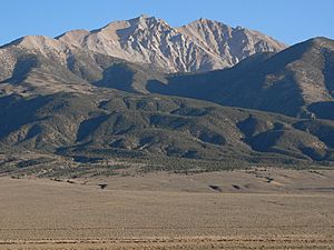
The county is known for its mountains. The Silver Peak Range and Monte Cristo Range are the main mountain ranges here.
Tallest Mountains in Esmeralda County
- Boundary Peak: This is the highest natural point in all of Nevada, standing at 13,147 feet (4,007 meters) tall.
- Piper Peak: This mountain is 9,450 feet (2,880 meters) high.
- Magruder Mountain: It reaches 9,044 feet (2,757 meters).
- Montezuma Peak: This peak is 8,373 feet (2,552 meters) tall.
- Emigrant Peak: It stands at 6,790 feet (2,070 meters).
Major Highways in Esmeralda County
 Interstate 11 (Future)
 U.S. Route 6
 U.S. Route 95
 State Route 264
 State Route 265
 State Route 266
 State Route 267
 State Route 773
 State Route 774
Neighboring Counties
Esmeralda County shares borders with several other counties:
- Mineral County to the northwest
- Nye County to the east
- Inyo County, California to the south
- Mono County, California to the west
Protected Natural Areas
Parts of these important natural areas are found within Esmeralda County:
- Death Valley National Park
- Inyo National Forest
- Boundary Peak Wilderness
Population Over Time
| Historical population | |||
|---|---|---|---|
| Census | Pop. | %± | |
| 1870 | 1,553 | — | |
| 1880 | 3,220 | 107.3% | |
| 1890 | 2,148 | −33.3% | |
| 1900 | 1,972 | −8.2% | |
| 1910 | 9,369 | 375.1% | |
| 1920 | 2,410 | −74.3% | |
| 1930 | 1,077 | −55.3% | |
| 1940 | 1,554 | 44.3% | |
| 1950 | 614 | −60.5% | |
| 1960 | 619 | 0.8% | |
| 1970 | 629 | 1.6% | |
| 1980 | 777 | 23.5% | |
| 1990 | 1,344 | 73.0% | |
| 2000 | 971 | −27.8% | |
| 2010 | 783 | −19.4% | |
| 2020 | 729 | −6.9% | |
| 2023 (est.) | 736 | −6.0% | |
| U.S. Decennial Census 1790-1960 1900-1990 1990-2000 2010-2020 |
|||
The population of Esmeralda County has changed a lot over the years. It saw a big increase during the gold rush in the early 1900s. After that, the population went down as the mines closed. In recent years, the population has stayed quite small, making it one of the least populated counties in the United States.
Education in Esmeralda County
The Esmeralda County School District has three elementary schools. These schools teach about 90 students. As mentioned earlier, students in grades 9-12 attend Tonopah High School. This high school is part of the Nye County School District.
The county is also served by Great Basin College. This college provides higher education opportunities for residents.
Towns and Ghost Towns
Esmeralda County has a few small communities where people live. It also has many interesting ghost towns. These are towns that were once busy, often during mining booms, but are now mostly abandoned.
Main Communities
- Dyer
- Goldfield (the county seat)
- Silver Peak
Famous Ghost Towns
- Alkali
- Arlemont
- Blair
- Blair Junction
- Coaldale
- Columbus
- Fish Lake Nevada
- Gilbert
- Gold Point
- Lida
- McLeans
- Millers
- Palmetto
See also
 In Spanish: Condado de Esmeralda para niños
 | Valerie Thomas |
 | Frederick McKinley Jones |
 | George Edward Alcorn Jr. |
 | Thomas Mensah |


