
Silver Peak Range facts for kids
Quick facts for kids Silver Peak Range |
|
|---|---|

Location in Nevada
|
|
| Highest point | |
| Peak | Piper Peak |
| Elevation | 2,880 m (9,450 ft) |
| Geography | |
| Country | United States |
| State | Nevada |
| District | Esmeralda County |
| Range coordinates | 37°39′11.750″N 117°50′40.347″W / 37.65326389°N 117.84454083°W |
| Topo map | USGS Mohawk Mine |
The Silver Peak Range is a group of mountains in the southwestern part of Esmeralda County, Nevada, United States. This range is known for its rugged beauty and important peaks. It stands tall in a desert region, offering amazing views.
Contents
Exploring the Silver Peak Range
The Silver Peak Range is a significant natural feature in Nevada. It helps form the eastern and southeastern edge of a large area called Fish Lake Valley. This valley is a wide, flat basin surrounded by mountains.
Neighboring Mountain Ranges
To the west and southwest of the Silver Peak Range, you can see the very tall White Mountains. These mountains are famous for their height. South of the Silver Peak Range are the Palmetto Mountains.
Important Peaks
Several important peaks are part of the Silver Peak Range. The highest point is Piper Peak. Other notable peaks include Red Mountain and Emigrant Peak. These peaks offer challenging climbs and great views.
Images for kids
-
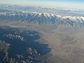
An aerial view of the Silver Peak Range. This photo looks northeast across Fish Lake Valley from the Nevada-California Border.
.jpg)
