Dyer, Nevada facts for kids
Quick facts for kids
Dyer, Nevada
|
|
|---|---|
 |
|
| Country | United States |
| State | Nevada |
| County | Esmeralda |
| Area | |
| • Total | 35.23 sq mi (91.25 km2) |
| • Land | 35.14 sq mi (91.01 km2) |
| • Water | 0.09 sq mi (0.23 km2) |
| Elevation | 4,880 ft (1,490 m) |
| Population
(2020)
|
|
| • Total | 232 |
| • Density | 6.60/sq mi (2.55/km2) |
| Time zone | UTC-8 (Pacific (PST)) |
| • Summer (DST) | UTC-7 (PDT) |
| ZIP code |
89010
|
| FIPS code | 32-20700 |
| GNIS feature ID | 859604 |
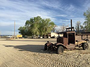
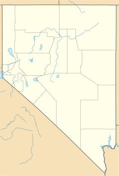
Dyer is a small town in Nevada, United States. It is not officially a city but is known as an unincorporated town. Dyer is found in Fish Lake Valley within Esmeralda County.
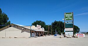
In 2018, about 324 people lived there. The town helps the people living in the countryside nearby. These people are mostly ranchers and Paiute people. Dyer has a gas station, a store, a cafe, a post office, and a small airport.
Dyer is located on State Route 264. This road is close to Nevada's border with California. It is about 25 miles (40 km) south of U.S. Route 6. It is also about 15 miles (24 km) north of Oasis, California. The town is part of a special area called the Dyer Census Designated Place.
People Living in Dyer
The number of people living in Dyer has changed over the years.
- In 2010, there were 259 people.
- In 2020, the population was 232 people.
This information comes from the U.S. Census, which counts people every ten years.
History of Dyer
The post office in Dyer has been open for a very long time. It started helping people send mail in 1889. The town got its name from a nearby place called Dyer's Ranch.
Schools in Dyer
Children in Dyer go to schools run by the Esmeralda County School District. This is for students from kindergarten up to eighth grade.
For high school, students from all over Esmeralda County go to Tonopah High School. This school is part of the Nye County School District.
If people want to go to college, the Great Basin College serves this area.
Weather in Dyer
Dyer has a semi-arid climate. This means it is quite dry, but not a true desert. It is often found near deserts.
The weather in Dyer can have big changes between seasons. Here are some facts about the weather:
- The coldest temperature ever recorded was -23°F (-31°C) in February.
- The hottest temperature ever recorded was 111°F (44°C) in July.
On average:
- The warmest month is July, with high temperatures around 93°F (34°C).
- The coldest month is December, with low temperatures around 15°F (-9°C).
Dyer does not get much rain. It gets about 0.4 to 0.5 inches (10-13 mm) of precipitation each month. It also gets some snow, especially in winter.
| Climate data for Dyer, Nevada | |||||||||||||
|---|---|---|---|---|---|---|---|---|---|---|---|---|---|
| Month | Jan | Feb | Mar | Apr | May | Jun | Jul | Aug | Sep | Oct | Nov | Dec | Year |
| Record high °F (°C) | 69 (21) |
76 (24) |
82 (28) |
95 (35) |
101 (38) |
106 (41) |
111 (44) |
105 (41) |
102 (39) |
93 (34) |
86 (30) |
72 (22) |
111 (44) |
| Mean daily maximum °F (°C) | 46 (8) |
52 (11) |
59 (15) |
67 (19) |
76 (24) |
86 (30) |
93 (34) |
91 (33) |
83 (28) |
71 (22) |
57 (14) |
47 (8) |
69 (21) |
| Mean daily minimum °F (°C) | 16 (−9) |
22 (−6) |
26 (−3) |
33 (1) |
39 (4) |
47 (8) |
53 (12) |
51 (11) |
43 (6) |
32 (0) |
22 (−6) |
15 (−9) |
33 (1) |
| Record low °F (°C) | −21 (−29) |
−23 (−31) |
−6 (−21) |
5 (−15) |
12 (−11) |
18 (−8) |
30 (−1) |
19 (−7) |
12 (−11) |
1 (−17) |
−20 (−29) |
−17 (−27) |
−23 (−31) |
| Average precipitation inches (mm) | 0.5 (13) |
0.5 (13) |
0.4 (10) |
0.5 (13) |
0.5 (13) |
0.3 (7.6) |
0.4 (10) |
0.4 (10) |
0.4 (10) |
0.4 (10) |
0.4 (10) |
0.4 (10) |
5.1 (129.6) |
| Average snowfall inches (cm) | 3.6 (9.1) |
2.3 (5.8) |
1.7 (4.3) |
1.4 (3.6) |
0.3 (0.76) |
0.3 (0.76) |
0.0 (0.0) |
0.0 (0.0) |
0.0 (0.0) |
0.2 (0.51) |
1.1 (2.8) |
1.7 (4.3) |
12.6 (31.93) |
| Source: Weatherbase | |||||||||||||
See Also
 In Spanish: Dyer (Nevada) para niños
 | Delilah Pierce |
 | Gordon Parks |
 | Augusta Savage |
 | Charles Ethan Porter |


