Bishop, California facts for kids
Quick facts for kids
City of Bishop
|
||
|---|---|---|
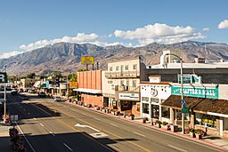
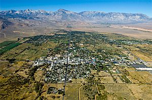
Downtown Bishop looking south along U.S. 395
|
||
|
||
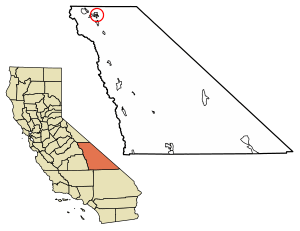
Location of Bishop in Inyo County, California
|
||
| Country | United States | |
| State | California | |
| County | Inyo | |
| Incorporated | May 6, 1903 | |
| Named for | Bishop Creek | |
| Area | ||
| • City | 1.91 sq mi (4.95 km2) | |
| • Land | 1.86 sq mi (4.83 km2) | |
| • Water | 0.05 sq mi (0.12 km2) 2.5% | |
| Elevation | 4,150 ft (1,260 m) | |
| Population
(2020)
|
||
| • City | 3,819 | |
| • Density | 2,048.82/sq mi (791.14/km2) | |
| • Metro | 14,500 | |
| Time zone | UTC−8 (Pacific) | |
| • Summer (DST) | UTC−7 (PDT) | |
| ZIP codes |
93514, 93515
|
|
| Area codes | 442/760 | |
| FIPS code | 06-06798 | |
| GNIS feature IDs | 2409852 | |
Bishop is a city in Inyo County, California, United States. It's the biggest and only officially recognized city in the county. Bishop is located in the northern part of the Owens Valley, which is part of the Mojave Desert. It sits high up, about 4,150 feet (1,265 meters) above sea level.
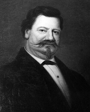
The city got its name from Bishop Creek. This creek flows from the Sierra Nevada mountains. The creek itself was named after Samuel Addison Bishop, one of the first settlers in the Owens Valley. Bishop is a busy place for homes and businesses. Many fun vacation spots and tourist attractions in the Sierra Nevada are also nearby.
The city covers about 1.9 square miles (4.9 square kilometers). This makes it the largest community in Inyo County by land area. In 2020, about 3,819 people lived in Bishop. However, the larger area around Bishop, including places like West Bishop, has over 14,500 residents. This makes it the largest settlement in Inyo County by far.
Did you know that many old Western movies were filmed in Bishop? Famous actors like John Wayne and Charlton Heston starred in some of these films.
Contents
History of Bishop
The first post office in the Bishop area opened in 1870. It was called Bishop Creek. Later, in 1889, the Bishop post office began.
In the early 1900s, the city of Los Angeles needed more water. So, in 1913, water from the Owens River was sent to Los Angeles through a large pipe system called the Los Angeles Aqueduct. Over the next few decades, the Los Angeles Department of Water and Power bought much of the land in the Owens Valley. This changed the area's way of life and environment a lot. Bishop's economy suffered because many farmers and ranchers sold their land.
However, a Bishop resident named Jack Foley helped the town. He was a sound effects expert for movies. He convinced movie studios in Los Angeles that Bishop was a great place to film Westerns. This helped bring some money back to the town.
Early Settlers and Names
Bishop was named after Samuel A. Bishop, one of the first European settlers. Owens Lake and the Owens River were named after Richard Owens. He was part of an exploration group led by John C. Frémont in 1845. The Paiute Indians had their own names for these places.
Inyo County is the second largest county in California. It's so big that several eastern U.S. states could fit inside it! Inyo County has both the highest and lowest points in the lower 48 states. Mount Whitney is 14,496 feet (4,418 meters) high. Badwater Basin in Death Valley is 282 feet (86 meters) below sea level.
The name "Inyo" is thought to come from a Paiute word. It might mean "dwelling place of the great spirit." But some experts think it's a misunderstanding of the Spanish word Indio, meaning "Indian." So, "Inyo" could actually mean "Indian Land."
First American Explorers
The first American explorers in the Owens Valley were mountain men like Jedediah Smith in 1833 and Joseph Walker in 1834. This part of California was very remote. Places like Walker Lake and Walker Pass are named after Joseph Walker.
A famous early explorer was John C. Fremont. He led a mapping trip in 1845. His group included the well-known scout Kit Carson, for whom Carson City, Nevada is named. Ed Kern, for whom Kern County, California is named, was also with them.
Bishop started because of the need for beef in a mining town called Aurora, Nevada. In 1861, cattlemen drove herds of cattle from California's San Joaquin Valley to Aurora. Some of them saw that the northern Owens Valley was perfect for raising animals.
Samuel Addison Bishop and his family arrived in the Owens Valley in August 1861. They brought about 600 cattle and 50 horses. Bishop was one of the first white settlers in the valley. He started a ranch called the San Francis Ranch. He sold beef to miners and businesses in Aurora. By 1862, a settlement called Bishop Creek grew up a few miles east of his ranch. Today, a monument marks the original site of Samuel Bishop's ranch.
In 1866, Inyo County was created. It was a very wild and new part of America. In 1871, a group of wranglers lost over 500 wild Spanish mustangs in the Owens Valley. The descendants of these wild horses still live near the California/Nevada border north of Bishop.
Water Challenges in Owens Valley
As Los Angeles grew, it needed more water. Fred Eaton, the mayor of Los Angeles, planned to bring water from Owens Valley to Los Angeles. Between 1905 and 1907, much of the land in the Owens Valley was bought from farmers. The real goal was to send Owens Valley water to Los Angeles.
The Los Angeles Aqueduct was built from 1907 to 1913. It was 223 miles (359 kilometers) long and used gravity to move the water. By 1928, Los Angeles controlled most of the water in Owens Valley. This caused many valley residents to leave. The Owens Lake and lower Owens River dried up. This conflict inspired the 1974 movie Chinatown.
Native American Culture
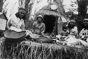
Native American people live in and around Bishop on four reservations. These include the Lone Pine, Fort Independence, Big Pine, and Bishop Indian Reservations. The Bishop Indian Reservation is the largest.
Geography of Bishop
Bishop is located west of the Owens River at the northern end of the Owens Valley. The city is on U.S. Route 395. This is the main highway that goes north and south through the Owens Valley. It connects Bishop to places like Reno, Nevada, and Los Angeles. Bishop is also where U.S. Route 6 begins.
The Paiute-Shoshone Indians control land just west of the town. The Los Angeles Department of Water and Power (DWP) owns much of the land around Bishop.
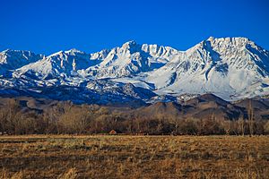
Bishop is just east of the Sierra Nevada mountains. It is west of the White Mountains. Many tall peaks are close to Bishop. These include Mount Humphreys (13,986 ft or 4,263 m), White Mountain Peak (14,242 ft or 4,341 m), and Mount Tom (13,658 ft or 4,163 m).
Bishop is known as the "Mule Capital of the World." Every year, a week-long festival called Bishop Mule Days is held. It celebrates the important role of pack mules in the area. Many tourists, especially from Southern California, visit for this festival.
Bishop is also very popular for rock climbing. There are over 2,000 places to go bouldering (a type of rock climbing) near the city. Climbers from all over the world come to visit.
Places to Visit Near Bishop
- Ancient Bristlecone Pine Forest
- Bishop Area Chamber of Commerce
- Bishop Visitors Bureau
- Eastern Sierra Regional Airport
- Inyo National Forest Supervisor's Office
- Keoughs Hot Springs
- Laws Rail Museum
- Paiute Indian Reservation
- Paiute-Shoshone Cultural Center Museum
Climate in Bishop
Bishop has a dry climate. It gets about 4.84 inches (123 mm) of rain each year. The wettest year on record was 1969, with 17.09 inches (434 mm) of rain. The driest was 2013, with only 1.33 inches (34 mm). It rains on about 26 days each year.
Snowfall averages about 6.8 inches (17 cm) per season. The snowiest season was from July 1968 to June 1969, with 57.1 inches (145 cm) of snow.
Bishop has about 104 days a year where the temperature reaches 90°F (32°C) or higher. About 29 days reach 100°F (38°C) or higher. The record high temperature was 111°F (44°C) on July 10, 2021. The record low was -8°F (-22°C) in December 1990 and 1988.
| Climate data for Bishop, California (Eastern Sierra Regional Airport), 1991–2020 normals, extremes 1943–present | |||||||||||||
|---|---|---|---|---|---|---|---|---|---|---|---|---|---|
| Month | Jan | Feb | Mar | Apr | May | Jun | Jul | Aug | Sep | Oct | Nov | Dec | Year |
| Record high °F (°C) | 77 (25) |
81 (27) |
87 (31) |
94 (34) |
104 (40) |
109 (43) |
111 (44) |
108 (42) |
106 (41) |
99 (37) |
84 (29) |
78 (26) |
111 (44) |
| Mean maximum °F (°C) | 67.3 (19.6) |
70.7 (21.5) |
77.3 (25.2) |
85.7 (29.8) |
94.3 (34.6) |
101.8 (38.8) |
105.4 (40.8) |
103.3 (39.6) |
97.5 (36.4) |
87.3 (30.7) |
76.0 (24.4) |
66.8 (19.3) |
106.1 (41.2) |
| Mean daily maximum °F (°C) | 54.7 (12.6) |
58.0 (14.4) |
66.0 (18.9) |
72.6 (22.6) |
81.6 (27.6) |
92.4 (33.6) |
98.6 (37.0) |
96.8 (36.0) |
88.8 (31.6) |
76.6 (24.8) |
63.1 (17.3) |
53.4 (11.9) |
75.2 (24.0) |
| Daily mean °F (°C) | 39.0 (3.9) |
42.0 (5.6) |
48.6 (9.2) |
54.7 (12.6) |
62.9 (17.2) |
71.9 (22.2) |
77.7 (25.4) |
75.4 (24.1) |
68.1 (20.1) |
57.0 (13.9) |
45.2 (7.3) |
37.5 (3.1) |
56.7 (13.7) |
| Mean daily minimum °F (°C) | 23.5 (−4.7) |
26.4 (−3.1) |
31.3 (−0.4) |
36.7 (2.6) |
44.2 (6.8) |
51.4 (10.8) |
56.7 (13.7) |
54.0 (12.2) |
47.2 (8.4) |
37.4 (3.0) |
27.2 (−2.7) |
21.7 (−5.7) |
38.1 (3.4) |
| Mean minimum °F (°C) | 11.0 (−11.7) |
14.5 (−9.7) |
18.9 (−7.3) |
24.1 (−4.4) |
32.4 (0.2) |
39.2 (4.0) |
46.7 (8.2) |
44.4 (6.9) |
36.8 (2.7) |
25.4 (−3.7) |
15.4 (−9.2) |
9.7 (−12.4) |
26.6 (−3.0) |
| Record low °F (°C) | −15 (−26) |
−3 (−19) |
9 (−13) |
15 (−9) |
25 (−4) |
25 (−4) |
34 (1) |
34 (1) |
25 (−4) |
13 (−11) |
5 (−15) |
−9 (−23) |
−15 (−26) |
| Average precipitation inches (mm) | 1.14 (29) |
0.89 (23) |
0.55 (14) |
0.22 (5.6) |
0.23 (5.8) |
0.13 (3.3) |
0.18 (4.6) |
0.07 (1.8) |
0.11 (2.8) |
0.35 (8.9) |
0.31 (7.9) |
0.66 (17) |
4.84 (123.7) |
| Average snowfall inches (cm) | 4.1 (10) |
0.1 (0.25) |
0.9 (2.3) |
trace | trace | 0 (0) |
0 (0) |
0 (0) |
0 (0) |
0 (0) |
0.4 (1.0) |
1.3 (3.3) |
6.8 (17) |
| Average precipitation days (≥ 0.01 in) | 3.9 | 4.0 | 2.9 | 1.9 | 1.7 | 1.5 | 1.7 | 1.5 | 1.7 | 1.5 | 2.3 | 3.0 | 27.6 |
| Average snowy days (≥ 0.1 in) | 1.3 | 0.4 | 0.5 | 0.1 | 0.1 | 0 | 0 | 0 | 0 | 0 | 0.4 | 0.8 | 3.6 |
| Source: NOAA, WRCC | |||||||||||||
People in Bishop
| Historical population | |||
|---|---|---|---|
| Census | Pop. | %± | |
| 1880 | 152 | — | |
| 1890 | 340 | 123.7% | |
| 1910 | 1,199 | — | |
| 1920 | 1,304 | 8.8% | |
| 1930 | 1,159 | −11.1% | |
| 1940 | 1,490 | 28.6% | |
| 1950 | 2,891 | 94.0% | |
| 1960 | 2,875 | −0.6% | |
| 1970 | 3,498 | 21.7% | |
| 1980 | 3,333 | −4.7% | |
| 1990 | 3,475 | 4.3% | |
| 2000 | 3,575 | 2.9% | |
| 2010 | 3,879 | 8.5% | |
| 2020 | 3,819 | −1.5% | |
| U.S. Decennial Census | |||
This information is about the people living within Bishop's city limits. In 2010, Bishop had a population of 3,879 people. The population density was about 2,030 people per square mile.
The "greater Bishop area" includes nearby neighborhoods. These are places like West Bishop and the Bishop Paiute Tribe lands. This larger area has about 11,000 more residents.
Population in 2010
In 2010, about 73.9% of Bishop's population was White. About 18.6% were from other races. About 30.9% of the people were Hispanic or Latino.
There were 1,748 households in Bishop. About 28.5% of these households had children under 18. The average household size was 2.16 people. The average family size was 3.07 people.
About 23.8% of the population was under 18 years old. About 15.8% were 65 years or older. The average age in Bishop was 38.9 years.
Getting Around Bishop
U.S. Route 395 is a major highway that goes through Bishop. It connects southern California to Reno, Nevada. U.S. Route 6 also starts in Bishop. It provides access to places like Tonopah, Nevada.
The Eastern Sierra Regional Airport offers flights. You can fly nonstop to Los Angeles, San Francisco, and Denver from here. These flights are operated by SkyWest Airlines as United Express.
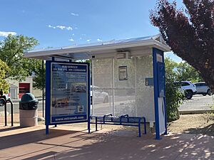
Eastern Sierra Transit provides bus service. You can take a bus as far north as Reno, Nevada. You can also go as far south as Lancaster, California.
Famous People from Bishop
Many interesting people have connections to Bishop:
- Horace M. Albright, who was the second director of the National Park Service, was born in Bishop in 1890.
- Television director David Barrett lives in Bishop. His brother, Stanton Barrett, is a stuntman and NASCAR driver.
- Actor Robert Bray, known for playing a forest ranger in the TV show Lassie, retired to Bishop.
- Artist Robert Clunie lived and painted in Bishop for many years.
- Elisha Cook Jr., a character actor in many films like The Maltese Falcon, lived in Bishop.
- Mountaineer Peter Croft lives in Bishop.
- Major Kern W. Dunagan, who received the Medal of Honor, graduated from Bishop High School.
- Actor Trevor Donovan was born in Bishop.
- Former child actor Richard Eyer became a teacher in Bishop.
- Cowboy poet Curley Fletcher (1892–1954) grew up in Bishop.
- Jack Foley is famous for creating sound effects for movies. The job of a "Foley artist" is named after him.
- Major League Baseball pitcher Hal Gregg lived in Bishop.
- Jill Kinmont, a famous ski racer who was paralyzed in an accident, grew up in Bishop. Her life story was made into two Hollywood movies.
- Actor Bill Mumy spent part of his childhood in Bishop. His father was a cattle rancher there.
- Bishop was the home of photographer and climber Galen Rowell and his wife Barbara.
- Tracy Smith, an Olympian and world-record holder in running, lived in Bishop. He coached the high school track team.
- Artist Alex Stenzel lives in Bishop.
- Author Claire Vaye Watkins was born in Bishop.
- Matt Williams, a former Major League Baseball player and manager, was born in Bishop.
Media in Bishop
AM Radio
- KBOV 1230 AM
FM Radio
- KWTW 88.5 FM
- KSRW 92.5 FM
- KRHV 93.3 FM
- KIBS 100.7 FM
- KMMT 106.5 FM
Newspapers
- Inyo Register
Television
- KVME-TV channel 20
See also
 In Spanish: Bishop (California) para niños
 | James Van Der Zee |
 | Alma Thomas |
 | Ellis Wilson |
 | Margaret Taylor-Burroughs |


