
Mount Tom (California) facts for kids
Mount Tom is a very tall and famous mountain located near the city of Bishop in Inyo County, eastern California. It is part of the amazing Sierra Nevada mountain range and sits just east of the main Sierra Crest. This mountain is also found within the beautiful John Muir Wilderness.
When you look west from the upper Owens Valley, Mount Tom and its neighbor, Basin Mountain, stand out as huge landmarks against the sky.
Quick facts for kids Mount Tom |
|
|---|---|

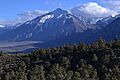
Mount Tom from the northeast
|
|
| Highest point | |
| Elevation | 13,658 ft (4,163 m) NAVD 88 |
| Prominence | 1,972 ft (601 m) |
| Parent peak | Mount Humphreys |
| Listing |
|
| Geography | |
| Location | Inyo County, California, U.S. |
| Parent range | Sierra Nevada |
| Topo map | USGS Mount Tom |
| Climbing | |
| First ascent | 1860s, Thomas Clark |
| Easiest route | Scramble, class 2 |
Contents
What is the History of Mount Tom?
This mountain got its name from Thomas Clark. He was one of the first people to live in the pioneer town of Owensville. People believe he was the first person to climb Mount Tom back in the 1860s.
Mount Tom and Mount Morgan were once important for mining. They were part of the Pine Creek mining area. This area produced a lot of tungsten, which is a strong metal, for many years in the 20th century. Today, most of the valuable minerals are gone, and the mines are closed.
Can You Climb Mount Tom?
Mount Tom is a very tall mountain, reaching 13,658 feet high. The valley at its base, the Owens Valley, is about 4,000 feet high. This means you climb almost 10,000 feet from the valley floor to the top!
Most common ways to climb Mount Tom are not super difficult. They are usually rated as "class 2" or "class 3" climbs. This means you might need to use your hands a bit to scramble over rocks, but you don't need special climbing ropes or gear. However, these climbs are very long and take a lot of energy.
It is possible to climb Mount Tom and come back down in one day. But only people who are in excellent physical shape should try this. It's a really tough hike!
Popular Hiking Routes
One common way to hike up Mount Tom is through Horton Creek Canyon. This trail is about 14 miles long, going up and back. You gain about 5,652 feet in height on this route.
The trailhead for Horton Creek Canyon starts at 8,000 feet elevation. You hike about 3.6 miles and gain 2,000 feet to reach Horton Lake. Some campers choose to stay overnight at Horton Lake. They need a special permit to camp in the wilderness. From Horton Lake, hikers go up the southern ridge of Mount Tom to the summit. This part involves about 1,750 feet of off-trail scrambling.
Technical Climbing Challenges
For experienced climbers, there are also more challenging routes on Mount Tom. These are called "technical climbing routes" because they require special skills and equipment.
- East Face Chimney Route: This route is rated as class IV, 5.9. The first people to climb it were Galen Rowell and Kevin Worral on August 18, 1988.
- Golden Thread Arete: This route is also rated as class IV, 5.9. Stuart Polack and Walt Vennum made the first climb on September 5, 1999. This route has 14 different sections on the north face of Mount Tom.
Is Mount Tom Good for Skiing?

Mount Tom is a popular place for back-country skiing. This means skiing down mountains that don't have ski lifts or groomed trails. People usually go skiing here in the spring when there is a lot of snow.
Elderberry Canyon is the most popular place for skiing on Mount Tom. Skiers can go down about 7,000 vertical feet. The slopes get steeper as you get closer to the top of the mountain.
On March 26, 2005, a group of skiers in Elderberry Canyon caused two separate snow slides. Sadly, two skiers were buried and did not survive, and another skier was hurt. This shows how important it is to be very careful and aware of snow conditions when skiing in the back-country.
Images for kids
-
Mount Tom from the northeast
-
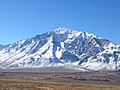
Mount Tom from the East. Elderberry Canyon is the clearly visible S shaped canyon.
