
Carson City, Nevada facts for kids
Quick facts for kids
Carson City, Nevada
|
|||
|---|---|---|---|
| Consolidated Municipality of Carson City | |||
|
Downtown Carson City
|
|||
|
|||
| Nicknames:
Carson, CC, The Capitol
|
|||
| Motto(s):
Proud of its Past...Confident of its Future
|
|||

Location within Nevada
|
|||

Carson City, Nevada
Location in Nevada

Carson City, Nevada
Location in the United States
|
|||
| Country | United States | ||
| State | Nevada | ||
| Founded | 1858 | ||
| Named for | Kit Carson | ||
| Area | |||
| • Total | 157.12 sq mi (406.94 km2) | ||
| • Land | 144.53 sq mi (374.34 km2) | ||
| • Water | 12.59 sq mi (32.59 km2) 8.0% | ||
| Elevation | 4,682 ft (1,427 m) | ||
| Population
(2020)
|
|||
| • Total | 58,639 | ||
| • Density | 405.71/sq mi (156.65/km2) | ||
| Time zone | UTC−8 (Pacific) | ||
| • Summer (DST) | UTC−7 (Pacific) | ||
| ZIP code |
89701–89706, 89711–89714, 89721,89703
|
||
| Area code(s) | 775 | ||
| GNIS feature ID | 863976 | ||
| Website | carson.org | ||
| Reference #: | 44 | ||
_at_Musser_Street_in_downtown_Carson_City,_Nevada.jpg)


.jpg)


Carson City, officially called the Consolidated Municipality of Carson City, is a special kind of city in the United States. It's an independent city, which means it acts like both a city and a county. It is also the capital of the state of Nevada.
In 2020, about 58,639 people lived here. This makes it the sixth largest city in Nevada. Most people live in Eagle Valley, which is on the eastern side of the Carson Range. This mountain range is part of the larger Sierra Nevada mountains. Carson City is about 30 miles south of Reno.
The city is named after Kit Carson (1809-1868), a famous explorer and mountain man. It started as a resting place for people traveling to California. But it grew much bigger when silver was found nearby in the Comstock Lode. Carson City has been Nevada's capital since 1864. It was once a busy center for the Virginia and Truckee Railroad, but the train tracks were removed in 1950.
Before 1969, Carson City was the main town of Ormsby County. That year, the city and county joined together. This made Carson City much larger. Its borders now reach all the way to Lake Tahoe and the California state line.
Contents
History of Carson City


The Washoe people have lived in the valley where Carson City is for about 6,000 years. They were the first inhabitants of this area.
Early Explorers and Settlers
The first European Americans arrived in January 1843. This group was led by John C. Frémont. He named the river flowing through the valley the Carson River. He did this to honor Kit Carson, who was a scout on his trip. Later, settlers called the area Washoe, after the native people.
By 1851, a ranch called Eagle Station was a trading post. It was a popular stop for travelers heading west on the California Trail. The valley and the trading post got their name from a bald eagle. An early settler hunted it and displayed it inside the post.
Becoming a Capital City
At first, this area was part of the larger Utah Territory. It was governed from Salt Lake City, which was far away. Early settlers wanted their own territory. A group of important settlers, led by Abraham Curry (1815-1873), looked for a good place for a new capital city.
In 1858, Abraham Curry bought Eagle Station. He renamed the settlement Carson City. Curry believed Carson City would become the capital. He even set aside a 10-acre plot in the middle of town for a future capitol building.
Growth from Mining and Statehood
In 1859, gold and silver were found nearby in the Comstock Lode. This discovery made Carson City's population grow quickly. The new governor chose Carson City as the territorial capital. This was a big win for Carson City over other towns like Virginia City.
When Nevada became the 36th state in 1864, Carson City was chosen as the permanent state capital. The city then grew into a busy business center. The Virginia and Truckee Railroad was built, connecting Carson City to Virginia City. A special channel was also built to bring logs from the Sierra Nevada mountains.
The Nevada State Capitol building was built between 1869 and 1871. The United States Mint also had a branch in Carson City from 1870 to 1893. This mint made gold and silver coins. Many people from China came to Carson City during this time. They worked on the transcontinental railroad and opened businesses. By 1880, nearly a thousand Chinese people lived in Carson City.
Challenges and Revival
Carson City's growth slowed down when a new railroad line bypassed the city. The population dropped to just over 1,500 people by 1930. The city became known as "America's smallest capital."
After World War II, Carson City slowly started to grow again. By 1960, its population was back to what it was during the mining boom of the 1880s.
Joining City and County
In 1969, Carson City and Ormsby County officially joined together. This made Carson City much larger. It absorbed other small towns like Empire City. Carson City could now say it was one of America's largest state capitals by land area.
In 1991, the city made a rule that no new building near the capitol could be taller than it. The Ormsby House is the tallest building in downtown Carson City, at 117 feet. It was finished in 1972.
Geography of Carson City
Most of Carson City is located in the Eagle Valley. The Carson River flows through the southwestern part of the city. Since the city and county joined, Carson City's borders now include parts of the Sierra Nevada mountains. It also includes small parts of Marlette Lake and Lake Tahoe.
The highest point in Carson City is Snow Valley Peak. It is 9,214 feet above sea level. Carson City is one of only two state capitals that share a border with another state. The other is Trenton, New Jersey.
Climate in Carson City
_-_CARSON_CITY,_NV.svg)
Carson City has a climate with cold winters and hot summers. It's in a high desert valley, about 4,802 feet above sea level. The city experiences four distinct seasons.
Winters usually have light to moderate snowfall. Most of the rain and snow falls in winter and spring. Summers and fall are usually quite dry. The hottest temperature ever recorded was 107°F on July 19, 1931. The coldest was -27°F on January 21, 1937.
Interestingly, the average temperature in Carson City increased by 4.1°F between 1984 and 2014. This was a bigger change than in any other city in the United States.
| Climate data for Carson City, Nevada, 1991–2020 normals, extremes 1893–present | |||||||||||||
|---|---|---|---|---|---|---|---|---|---|---|---|---|---|
| Month | Jan | Feb | Mar | Apr | May | Jun | Jul | Aug | Sep | Oct | Nov | Dec | Year |
| Record high °F (°C) | 72 (22) |
76 (24) |
81 (27) |
88 (31) |
94 (34) |
101 (38) |
107 (42) |
105 (41) |
103 (39) |
93 (34) |
79 (26) |
75 (24) |
107 (42) |
| Mean maximum °F (°C) | 59.3 (15.2) |
62.4 (16.9) |
70.7 (21.5) |
77.9 (25.5) |
85.6 (29.8) |
93.6 (34.2) |
99.0 (37.2) |
96.5 (35.8) |
91.9 (33.3) |
82.7 (28.2) |
70.7 (21.5) |
60.5 (15.8) |
99.7 (37.6) |
| Mean daily maximum °F (°C) | 45.5 (7.5) |
49.5 (9.7) |
56.2 (13.4) |
61.7 (16.5) |
70.4 (21.3) |
80.9 (27.2) |
89.5 (31.9) |
87.8 (31.0) |
80.7 (27.1) |
68.0 (20.0) |
54.5 (12.5) |
44.6 (7.0) |
65.8 (18.8) |
| Daily mean °F (°C) | 34.8 (1.6) |
38.3 (3.5) |
43.9 (6.6) |
48.8 (9.3) |
56.6 (13.7) |
65.0 (18.3) |
72.1 (22.3) |
70.2 (21.2) |
63.1 (17.3) |
52.2 (11.2) |
41.4 (5.2) |
34.2 (1.2) |
51.7 (10.9) |
| Mean daily minimum °F (°C) | 24.1 (−4.4) |
27.1 (−2.7) |
31.6 (−0.2) |
35.8 (2.1) |
42.9 (6.1) |
49.2 (9.6) |
54.8 (12.7) |
52.5 (11.4) |
45.6 (7.6) |
36.3 (2.4) |
28.4 (−2.0) |
23.9 (−4.5) |
37.7 (3.2) |
| Mean minimum °F (°C) | 6.9 (−13.9) |
11.7 (−11.3) |
17.4 (−8.1) |
22.3 (−5.4) |
29.7 (−1.3) |
35.8 (2.1) |
44.4 (6.9) |
42.1 (5.6) |
34.3 (1.3) |
21.8 (−5.7) |
11.4 (−11.4) |
6.2 (−14.3) |
0.6 (−17.4) |
| Record low °F (°C) | −27 (−33) |
−22 (−30) |
−5 (−21) |
3 (−16) |
18 (−8) |
25 (−4) |
33 (1) |
26 (−3) |
17 (−8) |
6 (−14) |
−5 (−21) |
−26 (−32) |
−27 (−33) |
| Average precipitation inches (mm) | 1.72 (44) |
1.48 (38) |
1.24 (31) |
0.51 (13) |
0.51 (13) |
0.37 (9.4) |
0.18 (4.6) |
0.14 (3.6) |
0.24 (6.1) |
0.55 (14) |
0.90 (23) |
1.50 (38) |
9.34 (237) |
| Average snowfall inches (cm) | 3.6 (9.1) |
1.7 (4.3) |
1.6 (4.1) |
0.0 (0.0) |
0.0 (0.0) |
0.0 (0.0) |
0.0 (0.0) |
0.0 (0.0) |
0.0 (0.0) |
0.0 (0.0) |
0.7 (1.8) |
6.4 (16) |
14.0 (36) |
| Average precipitation days (≥ 0.01 in) | 6.2 | 5.6 | 4.8 | 3.2 | 3.4 | 1.7 | 0.9 | 1.0 | 1.1 | 2.4 | 3.3 | 4.8 | 38.4 |
| Average snowy days (≥ 0.1 in) | 1.8 | 1.4 | 1.0 | 0.1 | 0.0 | 0.0 | 0.0 | 0.0 | 0.0 | 0.0 | 0.6 | 1.4 | 6.3 |
| Source 1: NOAA | |||||||||||||
| Source 2: National Weather Service | |||||||||||||
Fun Places to Visit in Carson City
Carson City has many interesting places to explore!
Museums and History
- Nevada State Capitol – This is the original capitol building. It still has the governor's offices and museum exhibits.
- Nevada State Museum – This museum used to be a branch of the United States Mint. It shows off rocks, mining history, and even a recreated Wild West village.
- Nevada State Railroad Museum – Here you can see old trains, like the Inyo locomotive.
- Stewart Indian School – This museum has items from the school's past teachers and students.
- Foreman-Roberts House Museum – A historic house with interesting architecture.
- Children's Museum of Northern Nevada – A museum just for kids!
Outdoor Adventures

- Silver Saddle Ranch – A great place to enjoy nature.
- Mexican Dam – A stone dam built in the 1860s across the Carson River.
- Prison Hill – You can find historic markers for the California Trail here.
- Kings Canyon Falls – Beautiful waterfalls in the Humboldt-Toiyabe National Forest.
- Snow Valley Peak – At 9,214 feet, this is the highest point in Carson City!
- Lake Tahoe–Nevada State Park – Enjoy the beautiful beaches along Lake Tahoe that are within the city limits, such as Chimney Beach and Secret Harbor.
- Washoe Lake State Park – This park is just north of the city.
- "C Hill" – A hill with a giant American Flag and a large "C" for Carson City.
Carson City Population Facts
Carson City is the smallest of the 366 major metropolitan areas in the United States.
| Historical population | |||
|---|---|---|---|
| Census | Pop. | %± | |
| 1850 | 714 | — | |
| 1860 | 714 | 0.0% | |
| 1870 | 3,042 | 326.1% | |
| 1880 | 4,229 | 39.0% | |
| 1890 | 3,950 | −6.6% | |
| 1900 | 2,100 | −46.8% | |
| 1910 | 2,466 | 17.4% | |
| 1920 | 1,685 | −31.7% | |
| 1930 | 1,596 | −5.3% | |
| 1940 | 2,478 | 55.3% | |
| 1950 | 3,082 | 24.4% | |
| 1960 | 5,163 | 67.5% | |
| 1970 | 15,468 | 199.6% | |
| 1980 | 32,022 | 107.0% | |
| 1990 | 40,443 | 26.3% | |
| 2000 | 52,547 | 29.9% | |
| 2010 | 55,274 | 5.2% | |
| 2020 | 58,639 | 6.1% | |
| 2023 (est.) | 58,036 | 5.0% | |
| U.S. Decennial Census 1790–1960 1900–1990 1990–2000 |
|||
In 2010, there were 55,274 people living in Carson City. Most people (81.1%) were White. About 21% of the population was Hispanic or Latino.
In 2010, most residents (82.3%) spoke English at home. About 14.1% spoke Spanish.
Sports and Fun in Carson City
Carson City does not have any professional sports teams. However, there are many sports and recreation activities available. The city has many parks with picnic tables, fishing spots, and courts for sports like softball, basketball, and tennis.
The biggest park is Mills Park, which is 51 acres. It even has a fun narrow-gauge train called the Carson & Mills Park Railroad.
While there are no ski slopes directly in Carson City, you can easily reach nearby ski areas. These include Heavenly Mountain Resort, Diamond Peak, and Mount Rose Ski Tahoe.
Famous People from Carson City
Carson City has been an important place for politics and business in Nevada. Many notable people have lived here. Every state governor since Denver S. Dickerson has lived in the Nevada Governor's Mansion in Carson City.
Here are some other well-known people who lived in Carson City:
- Mackena Bell, a racing car driver
- Orion Clemens, who was the Secretary of Nevada Territory
- Abraham Curry, one of the founders of Carson City
- Dat So La Lee, a famous Native American basket weaver
- George Washington Gale Ferris Jr., who invented the Ferris wheel
- Paul Laxalt, a former Governor and U.S. Senator
- Greg LeMond, a world champion cyclist
- Mark Twain, the famous author, lived here with his brother
- Matt Williams, a Major League baseball player
- Sarah Winnemucca, a Native American activist and author
Getting Around Carson City

Carson City has four main highways: Nevada State Route 28, U.S. Route 395, U.S. Route 50, and Interstate 580. Interstate 580 is the city's only freeway. Before 2012, Carson City was one of only five state capitals without a direct interstate highway.
The city has a bus system called Jump Around Carson, or JAC. It started in 2005 and uses smaller buses. There is also a bus service that connects Carson City to Gardnerville.
However, there are not many public transportation options to other cities. Passenger trains stopped serving Carson City in 1950. Greyhound bus services also stopped in 2006. Now, there is only a limited bus service to Reno on weekdays.
Carson City has its own airport, the Carson Airport. For bigger flights, people use the Reno–Tahoe International Airport, which is about 28 miles away.
Schools in Carson City
The Carson City School District runs all the public schools in the city. There are ten schools in total.
- Elementary Schools: Bordewich-Bray, Empire, Fremont, Fritsch, Mark Twain, and Al Seeliger.
- Middle Schools: Carson Middle School and Eagle Valley Middle School.
- High Schools: Carson High School and Pioneer High School.
The school district also supports Carson Montessori School. This is a public charter school for grades K-6. It's the only school in the district that operates with a balanced budget. In 2019, it received a special award from the Governor for its STEM programs.
Western Nevada College (WNC) is a two-year and four-year college in Carson City. It offers many different programs.
Carson City also has a public library, the Carson City Library.
Historic Buildings in Carson City
-
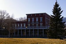
The historic St Charles Hotel -
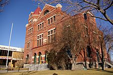
The former Carson City Post Office -
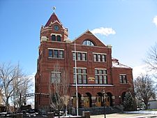
The Paul Laxalt State Building, once a U.S. Court House & Post Office


See also
 In Spanish: Carson City para niños
