Carson Range facts for kids
Quick facts for kids Carson Range |
|
|---|---|

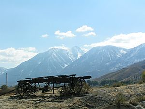
Looking south from Genoa, Nevada, toward the Carson Range
|
|
| Highest point | |
| Peak | Freel Peak |
| Elevation | 10,881 ft (3,317 m) |
| Dimensions | |
| Length | 50 mi (80 km) N-S |
| Width | 5–10 mi (8.0–16.1 km) E-W |
| Geography | |
| Country | United States |
| Range coordinates | 39°20′37.672″N 119°55′1.688″W / 39.34379778°N 119.91713556°W |
| Parent range | Sierra Nevada (U.S.) |
| Topo map | USGS Mount Rose |
The Carson Range is a mountain chain that branches off from the larger Sierra Nevada mountains. It stretches about 50 miles (80 km) from Carson Pass in the south all the way north to the Truckee River near Verdi, Nevada. You can find it in both eastern California and western Nevada.
Contents
Geography of the Carson Range
This mountain range is about 50 miles (80 km) long and 5 to 10 miles (8 to 16 km) wide. Most of it, about three-quarters, is located within the state of Nevada.
Rain Shadow Effect
The Carson Range, along with the main Sierra Nevada mountains, creates something called a rain shadow. This means they block moisture-filled clouds from reaching the areas to their east. Because of this, places like the Greater Reno Area and Carson City get much less rain and snow.
Snowfall and Water Sources
Unlike the taller mountains west of Lake Tahoe, the Carson Range usually loses its snow earlier in the spring, around April. It also gets its first snow later in the year, usually in December. In fact, these mountains receive about half the amount of snow compared to the mountains on the other side of Lake Tahoe. The melting snow from the Carson Range helps fill the Truckee River and the West Fork Carson River. It also adds water to Lake Tahoe and Marlette Lake.
Main Peaks of the Range
Here are some of the most important mountains in the Carson Range:
- Freel Peak (10,881 feet or 3,316 meters)
- Mount Rose (10,776 feet or 3,284 meters)
- Jobs Peak (10,633 feet or 3,240 meters)
- Slide Mountain (9,698 feet or 2,955 meters)
- East Peak (9,593 feet or 2,924 meters)
- Snow Valley Peak (9,214 feet or 2,808 meters)
Transportation and Trails
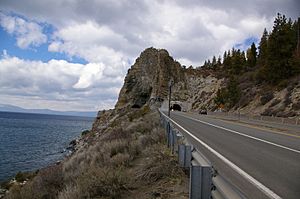
The western side of the Carson Range forms the eastern shoreline of Lake Tahoe. Roads like US 50 and NV 28 follow this shoreline, creating part of a loop around Lake Tahoe.
Connecting Routes
If you want to travel between Lake Tahoe and Carson City, you can take US 50 over Spooner Summit. Another option is NV 207 over Daggett Pass. In the northern part of the range, NV 431 winds through the mountains. This road connects Incline Village to Reno by crossing Mount Rose Summit.
Hiking Trails
The famous Tahoe Rim Trail also goes through this beautiful mountain range. It's a popular path for hikers and backpackers.
See also
 In Spanish: Cordillera Carson para niños
 | Selma Burke |
 | Pauline Powell Burns |
 | Frederick J. Brown |
 | Robert Blackburn |


