
Freel Peak facts for kids
Quick facts for kids Freel Peak |
|
|---|---|

Freel Peak from the Tahoe Rim Trail
|
|
| Highest point | |
| Elevation | 10,886 ft (3,318 m) NAVD 88 |
| Prominence | 3,146 ft (959 m) |
| Listing | California county high points 11th |
| Geography | |

Freel Peak
Location in California
|
|
| Location | El Dorado and Alpine counties, California, U.S. |
| Parent range | Carson Range |
| Topo map | USGS Freel Peak |
Freel Peak is a really tall mountain in California. It's part of the Carson Range, which is a smaller mountain chain connected to the huge Sierra Nevada mountains. You can find it close to the beautiful Lake Tahoe.
This mountain sits right on the border between two counties: El Dorado County and Alpine County. It also marks the edge between two big national forests: the Eldorado National Forest and the Humboldt-Toiyabe National Forest.
At about 10,886 feet (3,318 meters) high, Freel Peak is the tallest point in the entire Carson Range. It's also the highest spot in El Dorado County and the whole Lake Tahoe area! Because it's so high up, most of the rain that falls on the mountain actually comes down as snow.
How Freel Peak Got Its Name
In 1893, a group called the U.S. Geological Survey decided to give the mountain its current name, Freel Peak. Before that, it was known as Jobs Peak.
The mountain was named after James Freel. He was one of the very first people to settle and live in that area a long time ago.
Images for kids
-
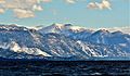
Freel Peak and Lake Tahoe
-
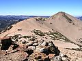
Freel Peak seen from Jobs Sister
-
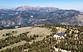
Freel Peak, Jobs Sister, and Jobs Peak seen from Hawkins Peak.


See also
 In Spanish: Pico Freel para niños
