Mount Rose Summit facts for kids
Mount Rose Summit is a mountain pass located in the beautiful Carson Range. It's found near two famous peaks, Mount Rose and Slide Mountain, just northeast of Incline Village. This amazing spot is 8,911 feet (about 2,716 meters) high!
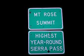
The pass is crossed by State Route 431, also known as the Mount Rose Highway. This highway reaches its highest point right here at the summit. It's also the highest mountain pass in the Sierra Nevada mountain range that stays open all year long. At the summit, you'll find a parking lot and a small building. These are handy spots for travelers to stop and enjoy the views. A dirt road that's now closed also leads from near the summit to the Mount Rose Ski Resort.

Quick facts for kids Mount Rose Summit |
|
|---|---|

Sign on the summit
|
|
| Elevation | 8,911 ft (2,716 m) |
| Traversed by | |
| Location | Washoe County, Nevada, United States |
| Range | Carson Range / Sierra Nevada |
| Coordinates | 39°18′48″N 119°53′50″W / 39.31333°N 119.89722°W |
| Topo map | USGS Mount Rose |
Contents
All About Mount Rose Summit
Mount Rose Summit is a super important spot in the Carson Range. This mountain range is part of the larger Sierra Nevada mountains. The summit is located in Washoe County, Nevada, in the United States. It's a key connection point between the city of Reno and the beautiful Lake Tahoe.
What is a Mountain Pass?
A mountain pass is like a natural doorway through a mountain range. It's the lowest or easiest path to cross over mountains. Imagine a giant wall of mountains; a pass is a dip or a saddle in that wall. These passes have been used for thousands of years by travelers, traders, and explorers. They help people and vehicles get from one side of a mountain range to the other. Mount Rose Summit is one such important natural pathway.
The Mount Rose Highway
The road that goes over Mount Rose Summit is Nevada State Route 431. It's often called the Mount Rose Highway. This highway is famous for its amazing views. It connects Reno to Incline Village on the north shore of Lake Tahoe.
Because the summit is so high, driving on the highway can be an adventure. In winter, you might see lots of snow! But even with heavy snow, the highway is usually kept open all year. This makes it a vital route for people living in or visiting the area. It's especially important for those heading to the ski resorts or enjoying the mountain scenery.
Things to Do at the Summit
Mount Rose Summit is more than just a place to drive through. It's a destination itself!
Scenic Overlooks
The summit offers breathtaking views of the surrounding mountains and valleys. You can see parts of the Sierra Nevada and the Lake Tahoe basin. Many people stop at the parking lot just to take photos and enjoy the fresh mountain air. It's a perfect spot for a quick break during a road trip.
Hiking and Trails
The summit is a popular starting point for hikers. One of the most famous trails from here leads to the top of Mount Rose. This hike offers even more incredible views and a chance to explore the high-altitude environment. There are also other trails for different skill levels, letting you explore the beautiful nature.
Winter Sports
During winter, the area around Mount Rose Summit becomes a snowy playground. The Mount Rose Ski Resort is very close by. It's a popular spot for skiing and snowboarding. The highway makes it easy for people to get to the slopes and enjoy winter sports. Even if you're not skiing, the snowy landscapes around the summit are beautiful to see.
 | Leon Lynch |
 | Milton P. Webster |
 | Ferdinand Smith |

