Gardnerville, Nevada facts for kids
Quick facts for kids
Gardnerville
|
|
|---|---|

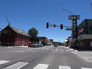
Downtown Gardnerville (2012)
|
|

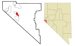
Location within Douglas County and Nevada
|
|
| Country | United States |
| State | Nevada |
| County | Douglas |
| Area | |
| • Total | 4.80 sq mi (12.43 km2) |
| • Land | 4.80 sq mi (12.43 km2) |
| • Water | 0.00 sq mi (0.00 km2) |
| Elevation | 4,751 ft (1,448 m) |
| Population
(2020)
|
|
| • Total | 6,211 |
| • Density | 1,293.96/sq mi (499.57/km2) |
| Time zone | UTC-8 (Pacific (PST)) |
| • Summer (DST) | UTC-7 (PDT) |
| ZIP codes |
89410, 89460
|
| Area code(s) | 775 |
| FIPS code | 32-26300 |
| GNIS feature ID | 0859798 |
| Reference #: | 129 |
Gardnerville is a small town in Douglas County, Nevada. It is located right next to Minden, which is the main town of the county. In 2020, about 6,211 people lived in Gardnerville.
A major road, U.S. Route 395, goes right through the middle of Gardnerville. Another road, State Route 207, also known as Kingsbury Grade, connects Gardnerville to Stateline and U.S. Route 50.
Contents
History of Gardnerville
Gardnerville was named after a local cattle rancher named John Gardner. He was an important person in the early days of the community.
For many years, Gardnerville was known as a "sundown town." This meant that a siren would sound at 6 p.m. every day. This siren was a signal for Native Americans to leave town before it got dark. This practice ended in 2023. A new law, called SB 391, was passed by the Nevada Legislature and signed by the governor to stop it.
Geography and Climate
Gardnerville covers an area of about 4.8 square miles (12.43 square kilometers). All of this area is land, with no large bodies of water.
What is Gardnerville's Climate Like?
Gardnerville has a climate often called "Mediterranean." This means it has dry summers and mild, wet winters. It's known as a Csb climate type.
| Climate data for Gardnerville, Nevada | |||||||||||||
|---|---|---|---|---|---|---|---|---|---|---|---|---|---|
| Month | Jan | Feb | Mar | Apr | May | Jun | Jul | Aug | Sep | Oct | Nov | Dec | Year |
| Mean daily maximum °F (°C) | 45 (7) |
51 (11) |
57 (14) |
64 (18) |
73 (23) |
82 (28) |
91 (33) |
89 (32) |
82 (28) |
70 (21) |
56 (13) |
47 (8) |
67 (19) |
| Mean daily minimum °F (°C) | 17 (−8) |
22 (−6) |
25 (−4) |
30 (−1) |
37 (3) |
43 (6) |
48 (9) |
46 (8) |
39 (4) |
30 (−1) |
23 (−5) |
18 (−8) |
32 (0) |
| Average precipitation inches (mm) | 1.6 (41) |
1.2 (30) |
0.8 (20) |
0.5 (13) |
0.5 (13) |
0.4 (10) |
0.3 (7.6) |
0.3 (7.6) |
0.3 (7.6) |
0.5 (13) |
0.9 (23) |
1.4 (36) |
8.6 (220) |
| Source: Weatherbase | |||||||||||||
Population of Gardnerville
The number of people living in Gardnerville has grown over the years. Here's how the population has changed:
| Historical population | |||
|---|---|---|---|
| Census | Pop. | %± | |
| 1990 | 2,177 | — | |
| 2000 | 3,357 | 54.2% | |
| 2010 | 5,656 | 68.5% | |
| 2020 | 6,211 | 9.8% | |
| U.S. Decennial Census 2020 Census |
|||
Gardnerville's Population in 2020
In 2020, the census showed that 6,211 people lived in Gardnerville. There were also 2,724 households, which are groups of people living together in homes.
Local Media and News
Gardnerville has local newspapers that keep residents informed. These include the Carson Valley Times and The Record-Courier.
Transportation in Gardnerville
Getting around Gardnerville is made easier by public transportation. The main bus service is Douglas Area Rural Transit. Eastern Sierra Transit also serves the area. For those needing to go to Carson City, the Tahoe Transportation District offers an express bus.
Education in Gardnerville
All schools in Gardnerville are part of the Douglas County School District. This district manages all public schools in Douglas County.
Famous People from Gardnerville
Some well-known individuals have connections to Gardnerville:
- Jill Derby – She was a regent for the Nevada System of Higher Education.
- Shawn Estes – A former Major League Baseball pitcher.
- Sable Starr – Known as a groupie.
- Stone Cold Steve Austin – A famous retired professional wrestler and actor.
See also
 In Spanish: Gardnerville (Nevada) para niños
 | Janet Taylor Pickett |
 | Synthia Saint James |
 | Howardena Pindell |
 | Faith Ringgold |

