
Mount Whitney facts for kids
Quick facts for kids Mount Whitney |
|
|---|---|
| Fisherman's Peak | |

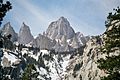
East Face close-up seen from the Whitney Portal
|
|
| Highest point | |
| Elevation | 14,505 ft (4,421 m) NAVD 88 |
| Prominence | 10,075 ft (3,071 m) |
| Isolation | 1,647 mi (2,651 km) |
| Parent peak | Pico de Orizaba |
| Listing |
|
| Naming | |
| Etymology | Josiah Whitney |
| Geography | |

Mount Whitney
Location in California

Mount Whitney
Location in the United States
|
|
| Location |
|
| Parent range | Sierra Nevada |
| Topo map | USGS Mount Whitney |
| Geology | |
| Age of rock | Cretaceous |
| Mountain type | Granite |
| Climbing | |
| First ascent | August 18, 1873 by Charles Begole, Albert Johnson, and John Lucas |
| Easiest route | Mount Whitney Trail (class 1) |
Mount Whitney is the highest mountain in the contiguous United States. It stands at an elevation of about 14,505 feet (4,421 m) (14,505 feet). The mountain is located in East–Central California, within the Sierra Nevada mountain range. It sits on the border between Inyo and Tulare counties in California.
Mount Whitney is about 84.6 miles (136.2 km) west-northwest of Badwater Basin in Death Valley National Park. Badwater Basin is the lowest point in North America. The western side of Mount Whitney is part of Sequoia National Park. The very top of the mountain marks the end of the John Muir Trail, a long path that stretches 211.9 mi (341.0 km) from Yosemite Valley. The eastern slopes of Mount Whitney are in Inyo National Forest.
Contents
Geography

The very top of Mount Whitney is on the Sierra Crest, which is like the backbone of the Sierra Nevada mountains. It's also part of the Great Basin Divide, meaning water on one side flows to the Pacific Ocean and on the other side flows into the Great Basin. Mount Whitney is surrounded by many other tall peaks in the Sierra Nevada.
The mountain rises very sharply from the Owens Valley to its east. It stands about 10,778 feet (3,285 m) (over 2 miles) above the town of Lone Pine, which is about 15 miles (24 km) away. On its western side, the slope is much gentler. It rises only about 3,000 feet (914 m) from the John Muir Trail at Guitar Lake.
Mount Whitney has a somewhat dome shape, but it also has famous jagged ridges that stick out. The mountain is so high that it is above the tree line, meaning no trees can grow there. It has an alpine climate, which is very cold, and an alpine tundra environment. Only a few tough plants can survive near the top, like the sky pilot. This is a small, low-growing plant. The only animals found near the summit are visitors, such as the Parnassius phoebus butterfly and the gray-crowned rosy finch.
Water Flow
Mount Whitney is the highest point on the Great Basin Divide. Water from the western side of the peak flows into Whitney Creek, which then joins the Kern River. The Kern River eventually reaches Bakersfield in the Tulare Basin. Today, most of this water is used for farming. In the past, during very rainy years, water from the Tulare Basin would flow into the San Joaquin River and then out to the Pacific Ocean.
On the eastern side, water from Mount Whitney flows into Lone Pine Creek. Much of this water is sent into the Los Angeles Aqueduct to provide water for the city of Los Angeles. Some water from the creek continues its natural path, joining the Owens River. This river ends at Owens Lake, which is a lake with no outlet to the ocean, located in the Great Basin.
How Mount Whitney Formed

The eastern side of Mount Whitney is much steeper than its western side. This is because the Sierra Nevada mountains were formed by a huge fault block. Imagine a cellar door: it's hinged on one side and slowly lifts up on the other. The Sierra Nevada is like that, hinged on the west and slowly rising on the east.
This rising is caused by a fault system that runs along the eastern base of the Sierra, right below Mount Whitney. So, the granite rock that makes up Mount Whitney is the same rock found thousands of feet lower in the Alabama Hills. The lifting of Mount Whitney (and the sinking of the Owens Valley next to it) is due to the same geological forces that are stretching the Earth's crust in much of the western United States.
The granite of Mount Whitney is part of a huge body of rock called the Sierra Nevada Batholith. Millions of years ago, during the Cretaceous period, melted rock from deep underground rose up beneath what is now Mount Whitney. This molten rock cooled and hardened underground to form large areas of granite. Over the last 2 to 10 million years, the Sierra Nevada was pushed upwards. As it rose, glaciers and rivers wore away the upper layers of rock, revealing the strong granite that forms Mount Whitney today.
Weather
Mount Whitney has a very cold alpine tundra climate. This means it's like the climate found in polar regions, even though it's not near the poles. Summer temperatures can change a lot, from below freezing (32 °F (0 °C)) to warmer highs.
There isn't a weather station right at the top of Mount Whitney. However, scientists use nearby data to estimate the weather conditions. The tables below show what the weather is generally like at an elevation just below the summit. In winter, every inch of rain can turn into about 15 to 40 inches of snow, depending on how cold it is.
| Climate data for Mount Whitney 36.5728 N, 118.3025 W, Elevation: 13,635 ft (4,156 m) (1991–2020 normals) | |||||||||||||
|---|---|---|---|---|---|---|---|---|---|---|---|---|---|
| Month | Jan | Feb | Mar | Apr | May | Jun | Jul | Aug | Sep | Oct | Nov | Dec | Year |
| Mean daily maximum °F (°C) | 25.2 (−3.8) |
23.0 (−5.0) |
25.8 (−3.4) |
31.2 (−0.4) |
38.7 (3.7) |
48.9 (9.4) |
55.2 (12.9) |
54.5 (12.5) |
49.6 (9.8) |
41.5 (5.3) |
31.9 (−0.1) |
24.3 (−4.3) |
37.5 (3.1) |
| Daily mean °F (°C) | 15.6 (−9.1) |
13.1 (−10.5) |
15.6 (−9.1) |
19.6 (−6.9) |
26.0 (−3.3) |
35.2 (1.8) |
41.2 (5.1) |
40.5 (4.7) |
36.8 (2.7) |
30.4 (−0.9) |
21.8 (−5.7) |
15.2 (−9.3) |
25.9 (−3.4) |
| Mean daily minimum °F (°C) | 6.0 (−14.4) |
3.3 (−15.9) |
5.4 (−14.8) |
8.0 (−13.3) |
13.4 (−10.3) |
21.6 (−5.8) |
27.2 (−2.7) |
26.5 (−3.1) |
24.1 (−4.4) |
19.2 (−7.1) |
11.6 (−11.3) |
6.2 (−14.3) |
14.4 (−9.8) |
| Average precipitation inches (mm) | 8.37 (213) |
8.88 (226) |
5.79 (147) |
3.94 (100) |
1.92 (49) |
0.51 (13) |
0.31 (7.9) |
0.19 (4.8) |
0.27 (6.9) |
1.90 (48) |
2.51 (64) |
7.91 (201) |
42.5 (1,080.6) |
| Source: PRISM Climate Group | |||||||||||||
| Climate data for Latitude: 36.5786, Longitude: -118.2920, Elevation: 13,346 ft (4,068 m) — 1981–2010 normals | |||||||||||||
|---|---|---|---|---|---|---|---|---|---|---|---|---|---|
| Month | Jan | Feb | Mar | Apr | May | Jun | Jul | Aug | Sep | Oct | Nov | Dec | Year |
| Mean daily maximum °F (°C) | 23.9 (−4.5) |
23.2 (−4.9) |
25.7 (−3.5) |
31.4 (−0.3) |
38.9 (3.8) |
47.7 (8.7) |
54.1 (12.3) |
53.7 (12.1) |
48.2 (9.0) |
40.6 (4.8) |
30.2 (−1.0) |
23.5 (−4.7) |
36.8 (2.6) |
| Daily mean °F (°C) | 15.0 (−9.4) |
13.7 (−10.2) |
15.6 (−9.1) |
20.0 (−6.7) |
27.9 (−2.3) |
36.9 (2.7) |
43.7 (6.5) |
42.7 (5.9) |
37.3 (2.9) |
29.9 (−1.2) |
20.9 (−6.2) |
15.2 (−9.3) |
26.6 (−3.0) |
| Mean daily minimum °F (°C) | 6.1 (−14.4) |
4.2 (−15.4) |
5.6 (−14.7) |
8.6 (−13.0) |
16.9 (−8.4) |
26.1 (−3.3) |
33.3 (0.7) |
31.7 (−0.2) |
26.4 (−3.1) |
19.2 (−7.1) |
11.7 (−11.3) |
6.9 (−13.9) |
16.4 (−8.7) |
| Average precipitation inches (mm) | 7.75 (197) |
7.44 (189) |
5.26 (134) |
3.33 (85) |
1.79 (45) |
0.98 (25) |
0.97 (25) |
0.77 (20) |
1.00 (25) |
1.79 (45) |
4.27 (108) |
6.54 (166) |
41.89 (1,064) |
| Source: PRISM Climate Group | |||||||||||||
History of Mount Whitney

In July 1864, a group of explorers from the California Geological Survey named the peak after Josiah Whitney. He was the state geologist of California and helped fund their expeditions. During the same trip, a geologist named Clarence King tried to climb Mount Whitney from the west. He almost made it to the top.
In 1871, King returned to climb what he thought was Mount Whitney. But he took a different path and actually climbed a nearby mountain called Mount Langley. When he realized his mistake in 1873, King finally climbed Mount Whitney. However, he was a month too late to be the first.
On August 18, 1873, three men from Lone Pine—Charles Begole, A. H. Johnson, and John Lucas—became the first to reach the highest point in the contiguous United States. They were on a fishing trip to Kern Canyon when they decided to climb the mountain. They called it "Fisherman's Peak."
In 1881, Samuel Pierpont Langley, who later founded the Smithsonian Astrophysical Observatory, stayed on the summit for some time. He made daily observations of the sun's heat. A group with him included Judge William B. Wallace. Wallace wrote that the Paiute Native Americans called Mount Whitney Too-man-i-goo-yah, which means 'the very old man.' They believed that a Great Spirit lived on the mountain.

In 1891, the United States Geological Survey officially recognized the name Mount Whitney. Even though the people of Lone Pine preferred their name, "Fisherman's Peak," they helped pay for the first trail to the summit. This trail was designed by Gustave Marsh and finished on July 22, 1904. Just four days later, the first recorded death on Mount Whitney happened. A man named Byrd Surby was struck by lightning while eating lunch on the summit. Because of this, Marsh started building a stone hut, which became the Smithsonian Institution Shelter. It was finished in 1909.
After World War II, there was an effort to rename the mountain after Winston Churchill, but the name Mount Whitney remained.
Climbing Mount Whitney
Trails

The most popular way to reach the summit is by using the Mount Whitney Trail. This trail starts at Whitney Portal, which is at an elevation of about 8,360 ft (2,548 m). Whitney Portal is about 13 mi (21 km) west of the town of Lone Pine. The hike is about 22 mi (35 km) round trip, and you gain over 6,100 ft (1,859 m) in elevation.
You need a permit to hike the trail all year round. To prevent too many people from using the trail, the Forest Service gives out a limited number of permits between May 1 and November 1. They hold a yearly lottery for hiking and backpacking permits. You can apply between February 1 and March 15. Any permits left after the lottery usually go on sale on April 1.
Most hikers plan to camp for one or two nights along the trail. However, people who are in very good shape sometimes try to hike to the summit and return to Whitney Portal in just one day. If you do a one-day hike, you need a special day-use permit that doesn't allow you to bring overnight camping gear like sleeping bags or tents. Day hikers often start before sunrise and hike for 12 to 18 hours.
Longer ways to reach Mount Whitney involve approaching from its west side. These routes connect to the Mount Whitney Trail near the summit, often using parts of the John Muir Trail.
Scrambles

The Mountaineer's Route is a gully on the north side of the east face. It was first climbed by John Muir. This route is considered a scramble, which means it's more difficult than hiking but usually doesn't require ropes. The fastest known time to go up this route to the summit and back to the portal is 3 hours and 10 minutes.
Technical Climbs
The very steep eastern side of Mount Whitney offers many challenging climbing routes. The East Face route, first climbed in 1931, is one of the Fifty Classic Climbs of North America. This route involves technical free climbing but is mostly class 4, meaning it requires some climbing skills. Other routes on the mountain can be even harder.
South of the main summit are several smaller peaks. From the west, they don't look like much, but from the east, they appear as sharp "needles." Climbing these needles offers some of the best "big-wall" climbing in the high Sierra. Two of these needles were named after people from an 1880 science trip: Keeler Needle for James Keeler and Day Needle for William Cathcart Day. Day Needle has since been renamed Crooks Peak, after Hulda Crooks, who hiked Mount Whitney every year until she was in her nineties.
Images for kids
-
East Face close-up seen from the Whitney Portal
See also
 In Spanish: Monte Whitney para niños
