
Sequoia National Park facts for kids
Quick facts for kids Sequoia National Park |
|
|---|---|
|
IUCN Category II (National Park)
|
|

The General Sherman Tree, the largest tree in the world (measured by volume), in 2022
|
|

Sequoia National Park
Location in California

Sequoia National Park
Location in the United States
|
|
| Location | Tulare County, California, United States |
| Nearest city | Visalia, California |
| Area | 404,064 acres (1,635.19 km2) |
| Established | September 25, 1890 |
| Visitors | 1,229,594 (in 2018) |
| Governing body | National Park Service |
Sequoia National Park is a special national park in California, a state in the United States. It was created on September 25, 1890. The park covers a huge area of about 404,063 acres (1,635 square kilometers).
This park is home to Mount Whitney, the highest point in the lower 48 United States. Mount Whitney stands tall at 14,505 feet (4,421 meters) above sea level. Sequoia National Park is right next to Kings Canyon National Park. Both parks are managed together by the National Park Service.
The park is very famous for its giant sequoia trees. One of these amazing trees is the General Sherman tree. It is one of the biggest trees on Earth! The General Sherman tree lives in the Giant Forest. This forest has five of the ten largest trees in the world.
Contents
Park History: People and the Land
The area that is now Sequoia National Park has a long history. Native American people lived here as early as 1000 A.D. The "Monachee" (also called Western Mono) Native Americans were the first to call this place home. They mostly lived near the Kaweah River in the park's foothills. Sometimes, they also lived higher up, even in the Giant Forest. About 2,000 Monachee people lived here permanently.
In the summer, the Tubatulabal Native Americans used the eastern part of the park for hunting. The Western Mono tribe would travel over high mountain passes to trade with other tribes. You can still see pictographs (rock paintings) in the park today. Some famous spots are Hospital Rock and Potwisha. There are also bedrock mortars, which were used to grind acorns. Acorns were a very important food for the Monachee people.

The first European settler to live here was Hale Tharp. He built a unique home from a hollowed-out giant sequoia log. This log cabin is in the Giant Forest, near Log Meadow. Tharp arrived in 1858 and met several groups of Native Americans. The largest group had about 600 people. Tharp became friends with the Western Mono tribe. They showed him the amazing Giant Forest Sequoia Grove.
More settlers came around 1860. Sadly, between 1860 and 1863, diseases like smallpox and measles killed most of the Native Americans. After this, the remaining Native Americans left the area. Their largest campsite, Hospital Rock, was empty by 1865. The Monachee people used to set small fires on purpose. This helped with hunting and farming. It also helped the plants grow naturally.
After the Native Americans left, Tharp and other settlers let sheep and cattle graze in the meadows. But they also respected the giant trees. They fought early battles to stop logging in the area. John Muir, a famous conservationist, sometimes visited Tharp's log cabin. You can still visit Tharp's Log in the Giant Forest today.
At first, Tharp's efforts to save the giant sequoias were not very successful. In the 1880s, a group of settlers formed the Kaweah Colony. They hoped to make money by selling sequoia wood. However, giant sequoia trees break easily. They were not good for timber, unlike their coast redwood relatives. Thousands of trees were cut down before logging stopped. In 1890, the year Sequoia National Park was founded, the National Park Service took over the Giant Forest. They quickly stopped all logging there.
.jpg)
When the Giant Forest became part of Sequoia National Park, the park's staff changed. Before the National Park Service, US Army troops managed the park. These included the 24th Regiment of Infantry and the 9th Regiment of Cavalry. They were known as the Buffalo Soldiers. These were African-American soldiers who joined the army in 1866. They were very important to the military.
The Buffalo Soldiers built park roads and buildings. They also managed the park, much like park rangers do today. They took on this role because the park did not have enough money to hire civilians. Captain Charles Young led the Buffalo Soldiers in Sequoia and General Grant Parks. Young was the third African American to graduate from West Point. He could not lead combat units because of segregation in the army.
However, Young showed great leadership in the National Park. He oversaw building projects. He also welcomed tourists and politicians. He set a high standard for his men. Young was also important for protecting Sequoia National Park early on. He allowed trees to be named after important people to help save them. For example, a redwood was named after Booker T. Washington, an escaped slave and activist.
Young also told the Secretary of the Interior that logging and carving names into trees were still happening. He said this was because forest protection laws were not being enforced. To fix this, Young increased patrols in busy areas. He also suggested buying private land around Sequoia. This would help protect the park even more.
The land purchases Young started were just the beginning. Sequoia National Park has grown many times over the years. A big expansion happened in 1926, thanks to Susan Thew Parks. One of the most recent expansions was in 1978. Groups like the Sierra Club fought against the Walt Disney Corporation. Disney wanted to buy a high-mountain mining site south of the park for a ski resort. This site, called Mineral King, was added to the park instead. Its name comes from 1873, when miners formed the Mineral King Mining District. Mineral King is the highest developed area in the park. It is a popular spot for backpackers.
Park Geology: Mountains, Rocks, and Caves
Sequoia National Park includes a large part of the Sierra Nevada mountain range. The park's mountains include Mount Whitney. It is the tallest mountain in the lower United States. The Great Western Divide runs alongside the Sierra Nevada crest. You can see it from places like Mineral King, Moro Rock, and the Giant Forest. Peaks in the Great Western Divide are over 12,000 feet (3,658 meters) high. Deep canyons are found between the mountains. These include Tokopah Valley, Deep Canyon, and Kern Canyon. Kern Canyon is more than 5,000 feet (1,524 meters) deep for 30 miles (48 kilometers).

Most of the mountains and canyons in the Sierra Nevada are made of granitic rocks. These rocks include granite, diorite, and monzonite. They formed when molten rock cooled deep inside the Earth. This molten rock was created by a process called subduction. During subduction, powerful forces pushed land under the Pacific Ocean beneath the North American Continent. Super-hot water from the ocean floor moved upward. It melted rock as it went. This happened during the Cretaceous Period, about 100 million years ago. Granitic rocks look speckled, like salt and pepper. This is because they contain minerals like quartz, feldspars, and micas. Valhalla, or the Angel Wings, are tall granite cliffs. They rise above the Middle Fork of the Kaweah River.
The Sierra Nevada is a young mountain range. It is probably less than 10 million years old. Forces inside the Earth caused the mountains to rise. Over the last 10 million years, there have been at least four ice ages. Thick ice covered the mountains during these times. Glaciers form when the weather is cool and wet for a long time. Glaciers move very slowly through the mountains. They carve deep valleys and sharp peaks. The many glaciers and the strong granitic rocks have created a landscape of hanging valleys, waterfalls, jagged peaks, alpine lakes, and glacial canyons.

The park's caves are mostly solutional caves. This means they formed when water dissolved marble rock. Marble is basically limestone that changed due to heat and pressure. This happened when the Sierra Nevada Batholith formed and rose. The fast rising of the batholith over the last 10 million years caused the metamorphic rocks at higher elevations to wear away. This exposed the granite underneath. So, most Sierra Nevada caves are found at middle and lower elevations (below 7,000 feet or 2,134 meters). However, some caves are found as high as 10,000 feet (3,048 meters) in the park. Examples include White Chief cave and Cirque Cave in Mineral King. These caves are carved out by the many seasonal streams in the park. Most of the larger caves in the park have, or used to have, streams flowing through them.
The park has more than 270 known caves. Lilburn Cave is California's longest cave. It has almost 17 miles (27 kilometers) of mapped passages. The only cave open to visitors for tours is Crystal Cave. It is the park's second-longest cave, at over 3.4 miles (5.5 kilometers). Alex Medley and Cassius Webster discovered Crystal Cave on April 28, 1918. The cave is always 48°F (9°C). You can only visit it with a guided tour. New caves are still being found in the park every year. The most recent major cave found was Ursa Minor in August 2006.
Park Climate
Sequoia National Park has five main climate types. These range from the highest to the lowest elevations. They include Tundra, Subarctic, Humid Continental, and two types of Mediterranean climates. Generally, the higher you go, the less rain or snow falls. The Giant Forest Visitor Center is at 6,444 feet (1,964 meters). The coldest temperature there usually gets is about 12.0°F (-11.1°C).
Park Animals and Plants
Sequoia National Park has five main types of natural plant life. These also depend on the elevation. They range from Alpine tundra at the highest points to Chaparral at the lowest.
Many animals live in this park. You might see a coyote, badger, or black bear. Other animals include bighorn sheep, deer, fox, and cougar. There are also eleven kinds of woodpecker, different kinds of turtle, and three kinds of owl. You might also spot an opossum, various snakes, a wolverine, a beaver, different kinds of frog, and a muskrat.
Fun Things to Do in the Park


Besides hiking, camping, fishing, and backpacking, here are some popular attractions for visitors:
- Sherman Tree Trail This is an easy 0.8-mile (1.3 km) paved trail. It goes from the parking lot down to the base of the General Sherman tree. You can walk through a grove of giant sequoia trees here.
- Tunnel Log This is a giant sequoia tree that fell across a park road in 1937. The tree was 275 feet (84 meters) tall and 21 feet (6.4 meters) wide. The next year, a crew cut an 8-foot (2.4-meter) tall, 17-foot (5.2-meter) wide tunnel through its trunk. This made the road usable again.
- Tokopah Falls The trail to Tokopah Falls starts near the Marble Fork Bridge in Lodgepole Campground. It is an easy 1.7-mile (2.7 km) walk one way. You walk along the Marble Fork of the Kaweah River to the impressive granite cliffs and waterfall of Tokopah Canyon. Tokopah Falls is 1,200 feet (365.8 meters) high. It looks most amazing in early summer.
- Crescent Meadow This is a small meadow surrounded by sequoia trees. It is in the Giant Forest area of Sequoia National Park. This mountain meadow is the end point of the High Sierra Trail. This trail goes from the meadow across the Great Western Divide to Mount Whitney. Hale Tharp, a pioneer, lived in this meadow and nearby Log Meadow. John Muir, a conservationist, visited this meadow many times. He called it the "Gem of the Sierra." The meadow is at the end of a three-mile (4.8 km) paved road. This road leaves the Generals Highway near the Giant Forest Museum.
- Moro Rock This is a large granite dome in the middle of the park. It is between Giant Forest and Crescent Meadow. A 351-step stairway was built into the rock in the 1930s. Visitors can hike to the top using these steps. The stairway is listed on the National Register of Historic Places. From the top of Moro Rock, you can see much of the park. This includes the Great Western Divide. Moro Rock is 6,725 feet (2,050 meters) high.
- Campgrounds The park has several places to camp. Three are in the foothills: Potwisha (42 sites), Buckeye Flat (28 sites), and South Fork (10 sites). Four campgrounds are at higher elevations, among conifer trees. These are between 6,650 and 7,500 feet (2,027 to 2,286 meters) high. They include Atwell Mill (21 sites), Cold Springs (40 sites), Lodgepole (214 sites), and Dorst Creek (204 sites).
- Giant Forest Museum This museum gives you information about giant sequoias. It also tells about the history of people in the forest. The museum building was built in 1928 by architect Gilbert Stanley Underwood.
Images for kids
-
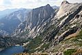
The High Sierra Trail above Hamilton Lake passes over the Great Western Divide
-
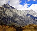
Mount Whitney


See also
 In Spanish: Parque nacional de las Secuoyas para niños
