Mount Langley facts for kids
Quick facts for kids Mount Langley |
|
|---|---|
 |
|
| Highest point | |
| Elevation | 14,032 ft (4,277 m) NAVD 88 |
| Prominence | 1,165 ft (355 m) |
| Parent peak | Mount Whitney |
| Listing |
|
| Geography | |
| Location | Inyo and Tulare counties, California, U.S. |
| Parent range | Sierra Nevada |
| Topo map | USGS Mount Langley |
| Climbing | |
| First ascent | Unknown, but prior to 1871 |
| Easiest route | Hike from New Army Pass on the south, class 1 |
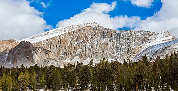
Mount Langley is a tall mountain located in the Sierra Nevada mountain range. It sits on the border between Inyo and Tulare counties in eastern California, in the southwestern United States. To its east is the Owens Valley, and to its west is the Kern River Valley.
Mount Langley is the ninth-highest peak in California. It is also the seventh-highest peak in the Sierra Nevada range. Mount Whitney, which is the tallest mountain in the mainland United States, is about 4.8 miles (7.7 km) to the northwest. Mount Langley is special because it is the southernmost "fourteener" in the United States. A fourteener is a mountain peak that is over 14,000 feet (4,267 meters) tall.
Contents
History of Mount Langley's Name
Today, this mountain is named after Samuel Pierpont Langley. He was an American astronomer and physicist. However, the mountain's name was a bit confusing at first.
In the early 1870s, some of the first climbers thought Mount Langley was actually Mount Whitney. So, they called it by that name. When they realized their mistake, people started calling the peak other names. These included Mount Corcoran, Cirque Peak, or Sheep Mountain. Later, Mount Corcoran and Cirque Peak became the names for other mountains. But the name Mount Langley stuck with local people. In 1943, the United States Board on Geographic Names officially made it the mountain's name.
Climbing Mount Langley
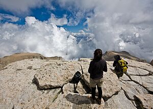
Mount Langley is known as one of the easier "fourteeners" to climb in California. Many people enjoy hiking to its top.
Starting Your Hike
A popular hiking trail begins at Horseshoe Meadow. This area is about 10,000 feet (3,048 meters) high. The trail takes you past the beautiful Cottonwood Lakes. It then climbs up through a place called New Army Pass.
Reaching the Summit
From New Army Pass, hikers travel across open land to Old Army Pass. Here, they can find the Mount Langley Trail. This trail is considered a "Class 1" climb, which means it's a walking trail. It follows a series of large rock piles, called cairns, for about two miles (3.2 km) to the very top. New Army Pass is about 7 miles (11 km) from the start of the trail at Horseshoe Meadow. It is an easier, but longer, way to reach Langley than using Old Army Pass directly.
Challenges with Snow
Because these passes are so high up, they are covered with snow for most of the year. New Army Pass faces south, so its snow tends to melt earlier in the season. Old Army Pass is usually only clear of snow for less than two months each year. This is typically from mid-August to early October. During the winter, the paved road to Horseshoe Meadow also closes. This makes reaching the summit much harder.
First Climbers
The first recorded climb of Mount Langley happened in 1871. It was done by Clarence King and a French mountaineer named Paul Pinson.
 | Misty Copeland |
 | Raven Wilkinson |
 | Debra Austin |
 | Aesha Ash |


