Swall Meadows, California facts for kids
Quick facts for kids
Swall Meadows, California
|
|
|---|---|

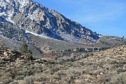
Top end of Swall Meadows (center), below the Wheeler Crest
|
|

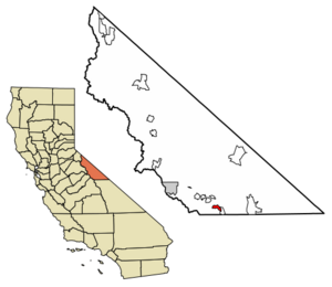
Location in Mono County and the state of California
|
|
| Country | United States |
| State | California |
| County | Mono |
| Area | |
| • Total | 4.462 sq mi (11.556 km2) |
| • Land | 4.462 sq mi (11.556 km2) |
| • Water | 0 sq mi (0 km2) |
| Elevation | 6,559 ft (1,999 m) |
| Population
(2020)
|
|
| • Total | 178 |
| • Density | 39.89/sq mi (15.40/km2) |
| Time zone | UTC-8 (Pacific (PST)) |
| • Summer (DST) | UTC-7 (PDT) |
| ZIP Code |
93514
|
| Area codes | 442/760 |
| FIPS code | 06-77430 |
| GNIS feature IDs | 2583158 |
Swall Meadows is a small community in Mono County, California, USA. It's a special kind of place called a "census-designated place" (CDP). This means it's a community that the government counts for population, but it's not officially a city or town.
In 2020, about 178 people lived there. It's mostly a quiet place where people live, some even have second homes there. There's a volunteer fire department, but you won't find any shops or businesses. The ZIP Code for Swall Meadows is 93514.
Contents
Exploring Swall Meadows' Location
Swall Meadows is located in a beautiful area of California. It sits on the side of a hill called the Sherwin Grade. This area is below the Wheeler Crest, which is part of the eastern Sierra Nevada mountains.
Elevation and Views
The community is quite high up, between 6,000 and 7,000 feet (about 1,800 to 2,100 meters) above sea level. From Swall Meadows, you can see amazing views. To the south, you can spot Mt. Tom in the Sierra Crest. Looking east, you'll see the Owens Valley and the White Mountains, which stretch into Nevada.
How to Get There
You can reach Swall Meadows from "old 395" or Lower Rock Creek Road. It's about 20 miles (32 km) north of Bishop and 25 miles (40 km) south of Mammoth Lakes by highway.
Deer Migration Route
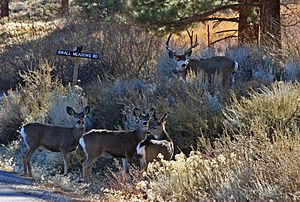
Swall Meadows is very important for mule deer. It's a key part of their migration route. These deer love to graze in the meadow and eat apples from old orchard trees in the area.
Land Area and Features
The community covers about 4.5 square miles (11.6 square kilometers) of land. At the higher, northwest end, there's an old place called Sky Meadows Ranch. Closer to the meadow, you'll find houses and the fire station. At the southeast end, there's a neighborhood known as Pinyon Ranch.
Plants and Conservation
The main plants you'll see are pinyon-juniper trees and sagebrush. But there are also streams and a meadow with different kinds of plants. You might find Jeffrey pine trees, willows, and even wild orchids. There are also old apple trees from a former orchard.
In 2011, a group called the Eastern Sierra Land Trust helped protect 104 acres (42 hectares) of the Swall Meadows meadow. This was done to make sure the migrating mule deer continue to have a safe place to live. Since 2001, other parts of Swall Meadows have also been protected.
Historic Wagon Road
Between Swall Meadows and a place called Paradise, you can still see parts of an old wagon road. This road used to climb about 3,000 feet (914 meters) up the Sherwin Grade from Owens Valley towards Crowley Lake.
Population Facts
In 2010, the population of Swall Meadows was 220 people. Most of the people living there owned their homes.
The Round Fire Event
On February 6, 2015, a large wildfire called the Round Fire affected Swall Meadows and a nearby community named Paradise. The fire burned about 7,000 acres (28 square kilometers) of land. Sadly, it destroyed 40 homes, with 39 of them being in Swall Meadows.
See also
 In Spanish: Swall Meadows (California) para niños
 | Selma Burke |
 | Pauline Powell Burns |
 | Frederick J. Brown |
 | Robert Blackburn |


