Lyon County, Nevada facts for kids
Quick facts for kids
Lyon County
|
|||
|---|---|---|---|
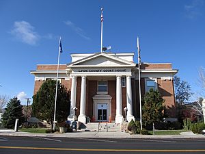
Lyon County Courthouse in Yerington
|
|||
|
|||
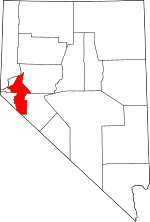
Location within the U.S. state of Nevada
|
|||
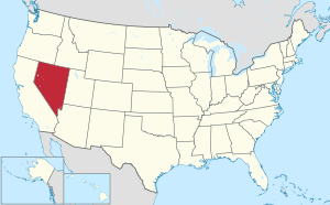 Nevada's location within the U.S. |
|||
| Country | |||
| State | |||
| Founded | 1861 | ||
| Named for | Nathaniel Lyon | ||
| Seat | Yerington | ||
| Largest city | Fernley | ||
| Area | |||
| • Total | 2,024 sq mi (5,240 km2) | ||
| • Land | 2,001 sq mi (5,180 km2) | ||
| • Water | 23 sq mi (60 km2) 1.1% | ||
| Population
(2020)
|
|||
| • Total | 59,235 | ||
| • Density | 29.266/sq mi (11.2998/km2) | ||
| Time zone | UTC−8 (Pacific) | ||
| • Summer (DST) | UTC−7 (PDT) | ||
| Congressional districts | 2nd, 4th | ||
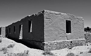
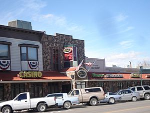
Lyon County is a place in Nevada, a state in the USA. In 2020, about 59,235 people lived there. Lyon County is part of a larger area that includes the cities of Reno and Carson City.
Contents
History of Lyon County
Lyon County was one of the first nine counties created in Nevada back in 1861. It's named after Nathaniel Lyon, who was the first general from the Union side to die in the American Civil War.
Its first main town, called the county seat, was Dayton. This happened on November 29, 1861. Before being called Dayton, the town was known as Nevada City (in 1862) and even Chinatown before that.
In 1909, the courthouse in Dayton burned down. Because of this, the county seat moved to Yerington in 1911. Some people thought the county was named after Captain Robert Lyon, a survivor of the 1860 Paiute War. However, records at the Nevada State Archives showed a county seal with a picture of the Civil War general, confirming who it was named after.
Railroads in Lyon County
Many important railroads passed through Lyon County. The Central Pacific Railroad, which was part of the first transcontinental railroad, ran through the county. Later, this railroad became the Southern Pacific Railroad. In 1996, it joined with the Union Pacific.
The Virginia and Truckee Railroad also goes through Mound House in western Lyon County. It travels from Carson City to Virginia City.
Another railroad, the narrow-gauge Carson and Colorado Railroad, started in Mound House. It connected with the Virginia and Truckee there. This line went east through Dayton, then south to the Mason Valley, and east again towards Walker Lake. Later, a branch line connected it to the Southern Pacific at Hazen.
The Eagle Salt Works Railroad was a shorter line, about 13.5 miles long. It mostly followed the old Central Pacific route from Luva (east of Fernley) to Eagle Salt Works. The Nevada Copper Belt Railroad ran on the west side of the Mason Valley.
Geography and Nature
Lyon County covers about 2,024 square miles. Most of this (2,001 square miles) is land, and a small part (23 square miles) is water. It is the third-smallest county in Nevada by land area.
The highest point in the county is on the northeast ridge of Middle Sister, which is about 10,565 feet (3,220 meters) high. The very top of Middle Sister is actually in Mono County, California. The highest mountain completely inside Lyon County is East Sister, which is nearby. Bald Mountain is the most noticeable peak in Lyon County.
A part of the Toiyabe National Forest is also located within Lyon County, offering natural beauty and outdoor activities.
Main Roads in Lyon County
 Interstate 11 (Future)
 Interstate 80
 Interstate 80 Business
 U.S. Route 50
 U.S. Route 50 Alternate
 U.S. Route 95 Alternate
 State Route 208
 State Route 338
 State Route 339
 State Route 340
 State Route 341
 State Route 427
 State Route 439 (Future)
 State Route 822
 State Route 823
 State Route 824
 State Route 825
 State Route 827
 State Route 828
 State Route 829
Neighboring Counties and City
Lyon County shares borders with several other counties and one independent city:
- Washoe County - to the north
- Storey County - to the northwest
- Churchill County - to the east
- Douglas County - to the west
- Carson City - to the west
- Mineral County - to the southeast
- Mono County, California - to the southwest
People and Population
| Historical population | |||
|---|---|---|---|
| Census | Pop. | %± | |
| 1870 | 1,837 | — | |
| 1880 | 2,409 | 31.1% | |
| 1890 | 1,987 | −17.5% | |
| 1900 | 2,268 | 14.1% | |
| 1910 | 3,568 | 57.3% | |
| 1920 | 4,078 | 14.3% | |
| 1930 | 3,810 | −6.6% | |
| 1940 | 4,076 | 7.0% | |
| 1950 | 3,679 | −9.7% | |
| 1960 | 6,143 | 67.0% | |
| 1970 | 8,221 | 33.8% | |
| 1980 | 13,594 | 65.4% | |
| 1990 | 20,001 | 47.1% | |
| 2000 | 34,501 | 72.5% | |
| 2010 | 51,980 | 50.7% | |
| 2020 | 59,235 | 14.0% | |
| 2023 (est.) | 62,583 | 20.4% | |
| U.S. Decennial Census 1790-1960 1900-1990 1990-2000 2010-2018 |
|||
In 2010, about 51,980 people lived in Lyon County. There were 19,808 households, and 14,137 families. The population density was about 26 people per square mile.
Most people in the county (85%) were white. About 2.5% were Native American, and 1.4% were Asian. People of Hispanic or Latino background made up about 14.8% of the population. Many residents had German, English, or Irish family backgrounds.
About 33.2% of households had children under 18 living with them. The average age of people in Lyon County was 40.9 years old.
Towns and Communities
Lyon County has several towns and communities.
Cities in Lyon County
Census-Designated Places
These are areas that are like towns but are not officially incorporated as cities.
Other Unincorporated Places
These are smaller communities that are not officially cities or census-designated places.
- Argo
- Artesia
- Bucklands Station
- Cambridge
- Churchhill
- Como
- Davis Station
- Greenville
- Hoye
- Hudson
- Johntown
- Ludwig
- Lux
- Marshland
- Mason
- Mound House
- Nordyke
- Palmyra
- Pine Grove
- Ramsey
- Rapids City
- Rockland
- Simpson
- Stone Cabin
- Sutro
- Sweetwater
- Thompson
- Tippecanoe
- Twin Flat
- Walker River
- Weeks
- Wellington
- Willington Springs
- Wichman
Education in Lyon County
The Lyon County School District runs sixteen schools in Lyon County. These schools provide education for children and teens living in the area.
Transportation in Lyon County
Getting around Lyon County is possible by air, rail, and road.
Air Travel
There are three public airports in Lyon County:
- Yerington Municipal Airport: This airport has a runway that is 5,800 feet long.
- Silver Springs Airport: This airport has a longer runway, 7,200 feet long. It's even big enough for planes like a Boeing 737. You can see its runway lights when driving on Fir Street.
- Tiger Field: Located near Fernley on US 95A, this airport has two runways. One is gravel and 2,750 feet long, and the other is paved and 5,600 feet long.
Train Travel
While the California Zephyr passenger train, run by Amtrak, passes through Lyon County, it does not stop there. The closest Amtrak stations where you can catch a train are in Reno and Winnemucca. The California Zephyr travels from the San Francisco Bay Area all the way to Chicago.
Fun and Entertainment
Lyon County offers various places for fun and entertainment. You can find several places with games, as well as many restaurants, clubs, and saloons to visit.
See also
 In Spanish: Condado de Lyon (Nevada) para niños
 | Tommie Smith |
 | Simone Manuel |
 | Shani Davis |
 | Simone Biles |
 | Alice Coachman |


