Silver Springs, Nevada facts for kids
Quick facts for kids
Silver Springs
|
|
|---|---|

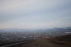
Silver Springs, from US 95A
|
|

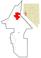
Location of Silver Springs, Nevada
|
|
| Country | United States |
| State | Nevada |
| County | Lyon |
| Area | |
| • Total | 77.14 sq mi (199.78 km2) |
| • Land | 71.63 sq mi (185.51 km2) |
| • Water | 5.51 sq mi (14.27 km2) |
| Elevation | 4,200 ft (1,300 m) |
| Population
(2020)
|
|
| • Total | 5,629 |
| • Density | 78.59/sq mi (30.34/km2) |
| Time zone | UTC-8 (PST) |
| • Summer (DST) | UTC-7 (PDT) |
| ZIP code |
89429
|
| Area code(s) | 775 |
| FIPS code | 32-67200 |
| GNIS feature ID | 0858187 |
Silver Springs is a community in Lyon County, Nevada, United States. It's known as a census-designated place (CDP). This means it's a community that looks like a town but doesn't have its own local government.
Silver Springs is located where two important roads meet: US 50 and US 95A. In 2020, about 5,629 people lived here. Nearby, you can find fun places like Lahontan Reservoir, Lahontan State Recreation Area, and the historic Fort Churchill State Historic Park. The area also has its own airport, the Silver Springs Airport.
Contents
Exploring Silver Springs' Location
Silver Springs is in the northern part of Lyon County. If you travel east on US 50, you'll reach Fallon in about 26 miles. Going west on US 50 for about 36 miles will take you to Carson City, which is the capital city of Nevada.
US 95A heads north for about 15 miles to Interstate 80 near Fernley. If you go south on US 95A for about 32 miles, you'll arrive at Yerington. Yerington is the main town for Lyon County, also known as the county seat.
Land and Water Around Silver Springs
Silver Springs covers a total area of about 77.14 square miles (199.7 square kilometers). Most of this area, about 71.63 square miles (185.5 square kilometers), is land. The rest, about 5.51 square miles (14.3 square kilometers), is water.
The Carson River flows along the southern and eastern edges of the community. On the eastern side, the river is held back to create the Lahontan Reservoir. The Lahontan State Recreation Area, which is a park by the reservoir, is also part of Silver Springs. Just west of Silver Springs, about 9 miles south of the US-50/US-95A crossing, is Fort Churchill State Historic Park.
Who Lives in Silver Springs?
| Historical population | |||
|---|---|---|---|
| Census | Pop. | %± | |
| 2020 | 5,629 | — | |
| U.S. Decennial Census | |||
In 2000, there were 4,708 people living in Silver Springs. There were 1,766 households, which are groups of people living together in one home. About 1,227 of these were families.
The community had about 65 people per square mile. Most of the people living in Silver Springs were White (about 91.67%). There were also smaller groups of African American, Native American, Asian, and Pacific Islander residents. About 4.63% of the population was Hispanic or Latino.
Daily Life in Silver Springs
About 28.7% of the households in 2000 had children under 18 living with them. More than half, about 55.3%, were married couples living together. The average household had about 2.59 people.
The population of Silver Springs included people of all ages. About 25% were under 18 years old. The median age was 40 years. This means half the people were younger than 40 and half were older.
See also
 In Spanish: Silver Springs (Nevada) para niños
 | Emma Amos |
 | Edward Mitchell Bannister |
 | Larry D. Alexander |
 | Ernie Barnes |

