Yerington, Nevada facts for kids
Quick facts for kids
Yerington, Nevada
|
|
|---|---|

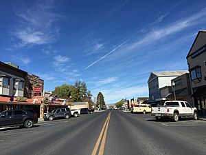
Main Street (SR 208) in downtown Yerington
|
|
| Nickname(s):
The Onion Capital of the West
|
|
| Motto(s):
"Preserving Our History While Planning Our Future"
|
|

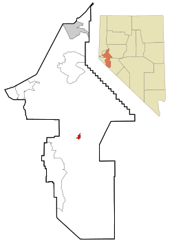
Location of Yerington, Nevada
|
|
| Country | United States |
| State | Nevada |
| County | Lyon |
| Founded | August 6, 1871 |
| Incorporated | March 17, 1907 |
| Named for | Henry M. Yerington |
| Area | |
| • Total | 29.46 sq mi (76.30 km2) |
| • Land | 29.46 sq mi (76.30 km2) |
| • Water | 0.00 sq mi (0.00 km2) |
| Elevation | 4,577 ft (1,395 m) |
| Population
(2020)
|
|
| • Total | 3,121 |
| • Density | 105.94/sq mi (40.90/km2) |
| Time zone | UTC−8 (PST) |
| • Summer (DST) | UTC−7 (PDT) |
| ZIP code |
89447
|
| Area code(s) | 775 |
| FIPS code | 32-85400 |
| GNIS feature ID | 2412318 |
Yerington is a city located in Lyon County, Nevada, in the United States. In 2010, about 3,048 people lived there. It's the main city, or county seat, of Lyon County. The city was named after Henry M. Yerington, who was in charge of the Virginia and Truckee Railroad for many years.
Contents
History of Yerington
Native People of the Area
The Yerington Paiute Tribe of the Yerington Colony and Campbell Ranch has its main office in Yerington. These people, who call themselves Numu (meaning "human beings"), have lived in the Smith and Mason Valleys of Northwestern Nevada since about 1000 A.D.
How the City Started
Yerington has had a few different names over time. It was once called Greenfield, Mason Valley, and even Pizen Switch. The name "Pizen Switch" was a funny nickname. It came from the fact that Yerington was a transfer stop for trains, and the local whiskey was said to be so bad it was called "poison." People said "poison" like "pizen," and the name stuck!
The city was officially started on August 6, 1871. It became an incorporated city on March 17, 1907. After the Dayton Court House burned down in 1909, Yerington became the county seat in 1911.
A Strange World War II Event
During World War II, Japan sent many Fu-Go balloon bombs towards the United States. One of these balloons landed on the Wilson Ranch near Yerington. The ranchers didn't know what it was. They tried to tell the authorities by mail, but they didn't get a reply until after they had cut up the balloon and used it as a tarp for their hay!
Geography and Location
Yerington is found where two important roads meet: US 95A and Nevada State Route 208. It is about 33 miles (53 km) south of Silver Springs and U.S. Route 50. It's also 47 miles (76 km) south of Fernley and Interstate 80.
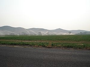
The city covers a total area of about 29.46 square miles (76.3 square kilometers), and all of it is land. The Walker River starts about 9 miles (14 km) south of Yerington. This river is very important for watering the farms in the Mason Valley, where Yerington is located.
Climate and Weather
Yerington has a dry climate, which is either a cool desert climate or a cool semi-arid climate. It doesn't get much rain or snow because of the mountains nearby. For example, it gets only half as much rain as Carson City.
- Summers: Summers are usually hot during the day. However, because the city is high up and the air is dry, it cools down nicely at night. Temperatures can go above 100°F (38°C) about 8 days each summer.
- Winters: Winters are sunny but cool or cold. Mornings are often freezing. It doesn't snow much in most years. The coldest temperature ever recorded was -26°F (-32°C) in January 1937.
| Climate data for Yerington, Nevada, 1991–2020 normals, extremes 1894–present | |||||||||||||
|---|---|---|---|---|---|---|---|---|---|---|---|---|---|
| Month | Jan | Feb | Mar | Apr | May | Jun | Jul | Aug | Sep | Oct | Nov | Dec | Year |
| Record high °F (°C) | 72 (22) |
76 (24) |
84 (29) |
92 (33) |
100 (38) |
105 (41) |
107 (42) |
106 (41) |
102 (39) |
93 (34) |
82 (28) |
74 (23) |
107 (42) |
| Mean maximum °F (°C) | 61.2 (16.2) |
66.0 (18.9) |
74.1 (23.4) |
80.1 (26.7) |
90.3 (32.4) |
97.1 (36.2) |
102.1 (38.9) |
100.3 (37.9) |
95.1 (35.1) |
85.5 (29.7) |
71.3 (21.8) |
61.5 (16.4) |
102.4 (39.1) |
| Mean daily maximum °F (°C) | 45.8 (7.7) |
51.1 (10.6) |
59.3 (15.2) |
65.4 (18.6) |
74.6 (23.7) |
85.0 (29.4) |
93.4 (34.1) |
91.9 (33.3) |
83.5 (28.6) |
69.6 (20.9) |
55.0 (12.8) |
44.2 (6.8) |
68.2 (20.1) |
| Daily mean °F (°C) | 34.2 (1.2) |
38.4 (3.6) |
45.5 (7.5) |
51.1 (10.6) |
59.6 (15.3) |
68.5 (20.3) |
76.0 (24.4) |
74.2 (23.4) |
66.2 (19.0) |
53.8 (12.1) |
41.3 (5.2) |
33.0 (0.6) |
53.5 (11.9) |
| Mean daily minimum °F (°C) | 22.7 (−5.2) |
25.7 (−3.5) |
31.8 (−0.1) |
36.8 (2.7) |
44.6 (7.0) |
52.0 (11.1) |
58.6 (14.8) |
56.5 (13.6) |
48.9 (9.4) |
38.0 (3.3) |
27.6 (−2.4) |
21.8 (−5.7) |
38.8 (3.7) |
| Mean minimum °F (°C) | 9.9 (−12.3) |
13.8 (−10.1) |
19.5 (−6.9) |
25.7 (−3.5) |
32.6 (0.3) |
39.5 (4.2) |
49.9 (9.9) |
47.8 (8.8) |
37.4 (3.0) |
24.5 (−4.2) |
13.6 (−10.2) |
7.4 (−13.7) |
4.6 (−15.2) |
| Record low °F (°C) | −26 (−32) |
−23 (−31) |
−2 (−19) |
5 (−15) |
15 (−9) |
26 (−3) |
30 (−1) |
26 (−3) |
11 (−12) |
5 (−15) |
−6 (−21) |
−20 (−29) |
−26 (−32) |
| Average precipitation inches (mm) | 0.54 (14) |
0.40 (10) |
0.49 (12) |
0.33 (8.4) |
0.63 (16) |
0.42 (11) |
0.28 (7.1) |
0.22 (5.6) |
0.12 (3.0) |
0.34 (8.6) |
0.39 (9.9) |
0.42 (11) |
4.58 (116.6) |
| Average snowfall inches (cm) | 0.6 (1.5) |
0.4 (1.0) |
0.0 (0.0) |
0.3 (0.76) |
0.0 (0.0) |
0.0 (0.0) |
0.0 (0.0) |
0.0 (0.0) |
0.0 (0.0) |
0.0 (0.0) |
1.0 (2.5) |
0.9 (2.3) |
3.2 (8.06) |
| Average precipitation days (≥ 0.01 in) | 3.6 | 3.1 | 3.3 | 2.2 | 3.7 | 2.3 | 1.4 | 1.4 | 1.0 | 1.8 | 2.4 | 3.0 | 29.2 |
| Average snowy days (≥ 0.1 in) | 0.4 | 0.3 | 0.1 | 0.1 | 0.0 | 0.0 | 0.0 | 0.0 | 0.0 | 0.0 | 0.2 | 0.6 | 1.7 |
| Source 1: NOAA | |||||||||||||
| Source 2: National Weather Service | |||||||||||||
Population and People
| Historical population | |||
|---|---|---|---|
| Census | Pop. | %± | |
| 1910 | 682 | — | |
| 1920 | 1,169 | 71.4% | |
| 1930 | 1,005 | −14.0% | |
| 1940 | 964 | −4.1% | |
| 1950 | 1,157 | 20.0% | |
| 1960 | 1,764 | 52.5% | |
| 1970 | 2,010 | 13.9% | |
| 1980 | 2,021 | 0.5% | |
| 1990 | 2,367 | 17.1% | |
| 2000 | 2,883 | 21.8% | |
| 2010 | 3,048 | 5.7% | |
| 2020 | 3,121 | 2.4% | |
| U.S. Decennial Census | |||
In 2010, the city of Yerington had 3,048 people living there. There were 1,302 households, and 747 of those were families. The population density was about 1,793 people per square mile.
- Most people (80.2%) were White.
- About 6.8% were Native American.
- About 8.9% were from other races.
- Around 18.8% of the population identified as Hispanic or Latino.
In 2000, there were 2,883 people. About 27.7% of households had children under 18. The average age of people in the city was 41 years old.
Famous People from Yerington
- Nevada Barr (born 1952) – A mystery writer known for her Anna Pigeon series.
- Jesse Brinkley (born 1976) – A professional boxer who was on the TV show The Contender.
- Joe Dini (1929–2014) – A long-time member of the Nevada Assembly, which is part of the state government.
- Wovoka (1856–1932) – Also known as Jack Wilson, he was an important Paiute religious leader.
See also
 In Spanish: Yerington (Nevada) para niños
 | Percy Lavon Julian |
 | Katherine Johnson |
 | George Washington Carver |
 | Annie Easley |


