Walker River facts for kids
Quick facts for kids Walker River |
|
|---|---|

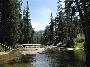
West Walker River near Leavitt Meadows
|
|

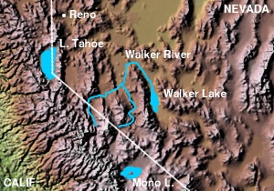
Walker River and Walker Lake
|
|
| Country | United States |
| State | Nevada |
| Cities | Yerington, Mason, Wabuska |
| Physical characteristics | |
| Main source | West Walker River Sierra Nevada, California 9,640 ft (2,940 m) 38°08′24″N 119°30′28″W / 38.14000°N 119.50778°W |
| 2nd source | East Walker River Bridgeport Valley, California 6,570 ft (2,000 m) 38°11′44″N 119°17′09″W / 38.19556°N 119.28583°W |
| River mouth | Walker Lake Mineral County, Nevada 3,973 ft (1,211 m) 38°48′56″N 118°44′40″W / 38.81556°N 118.74444°W |
| Length | 62 mi (100 km) |
| Basin features | |
| Basin size | 3,134 sq mi (8,120 km2) |
The Walker River is a river in Nevada, a state in the United States. It is about 62 miles (100 km) long. This river gets most of its water from snow melting in the Sierra Nevada mountains in California.
The Walker River flows through a dry area called the Great Basin, southeast of Reno. It ends in a lake called Walker Lake. This lake is a "closed basin," meaning water flows in but doesn't flow out to the ocean.
The river is very important for providing water to farms in Nevada. However, so much water is taken out for farming that the level of Walker Lake has dropped a lot. Between 1882 and 2010, the lake's water level fell by 160 feet (49 meters). The river was named after an explorer named Joseph R. Walker.
Contents
Where Does the Walker River Flow?
The Walker River starts in southern Lyon County, about 9 miles (14 km) south of Yerington. It forms when two smaller rivers, the East Walker and West Walker rivers, join together.
The West Walker River's Journey
The West Walker River begins high up in the Sierra Nevada mountains at Tower Lake in Mono County, California. It starts at an elevation of 9,623 feet (2,933 meters) above sea level. It flows north through a rough canyon. This canyon is also where U.S. Route 395 is located.
The river then reaches Antelope Valley. Here, some of its water is sent to the Topaz Lake reservoir. It then enters Nevada in Douglas County and turns northeast. It flows through Hoye Canyon into Lyon County, then across the Smith Valley, past Smith, and finally through Wilson Canyon. It then joins the East Walker River in the Mason Valley.
The East Walker River's Journey
The East Walker River also starts in Mono County, California, in the Bridgeport Valley. It gets water from several streams in the Sierra Nevada, like Buckeye, Robinson, Green, and Virginia Creeks.
After forming the Bridgeport Reservoir near the town of Bridgeport, the East Walker River flows northeast into Nevada. It enters Lyon County, receives water from Rough Creek, and flows north. It runs along the eastern edge of the Toiyabe National Forest before meeting the West Walker River.
The Main Walker River's Path
After the two branches join, the main Walker River flows north through the Mason Valley, past Yerington. It then turns sharply southeast around the north end of the Wassuk Range. It flows through the Walker River Indian Reservation, where a dam creates Weber Reservoir.
The river flows past Schurz. Here, most of the remaining water is taken out for farming. The river then continues south, usually in wetter seasons, to empty into Walker Lake. This lake is about 20 miles (32 km) north-northwest of Hawthorne.
Normally, the Walker River would send about 461 cubic feet (13 cubic meters) of water per second into Walker Lake. However, this amount changes a lot between wet and dry years. Because so much water is used for farming, the average flow into Walker Lake is now only about 104 cubic feet (3 cubic meters) per second.
This has caused the lake's level to drop by 160 feet (49 meters) between 1882 and 2010. About 20 feet (6 meters) of this drop happened just between 1996 and 2010. The lake has lost more than half of its original surface area and 80 percent of its water volume.
The Walker River's Watershed
A drainage basin is an area of land where all the water flows into a single river or lake. The Walker River's basin is a "closed basin" (or endorheic), meaning its water does not reach the ocean. This basin covers about 3,082 square miles (7,982 square kilometers). This is about 80 percent of the total area that sends water to Walker Lake.
The United States Geological Survey divides the Walker River basin into four smaller parts:
- The West Walker basin: 992 square miles (2,570 square kilometers)
- The East Walker basin: 1,080 square miles (2,800 square kilometers)
- The main Walker River basin: 1,010 square miles (2,600 square kilometers)
- The Walker Lake basin: 835 square miles (2,160 square kilometers)
The Walker River starts high up along the Sierra Crest, at elevations of 12,000 feet (3,700 meters) or more. The southern edge of the Walker River basin is the northern border of Yosemite National Park. The Sweetwater Mountains are located between the West Walker and East Walker Rivers. The Pine Nut Mountains are northwest of the West Walker.
The lower Desert Mountains form the northern edge of the Walker River basin. The Wassuk Range lies between the main Walker River and Walker Lake to the east. The Walker River has to flow a long way around the north end of this mountain range to reach Walker Lake.
The river helps water about 132,063 acres (53,444 hectares) of farmland. About 38 percent of this land is in California, and 62 percent is in Nevada.
River History
People have lived in the Walker River basin for a very long time, possibly as far back as 11,000 years ago. Before Europeans arrived, the Northern Paiute people lived in this area.
The first European to likely see the Walker River was a fur trapper named Peter Skene Ogden in 1829. He was looking for beaver south of the Humboldt Sink.
In 1833, Joseph R. Walker led a group to find a route from the Great Salt Lake to California. They traveled along the Humboldt River, then the Humboldt Sink, and the Carson Sink. From there, they went into the Sierra Nevada mountains, possibly using the Carson River or the Walker River. Later, John C. Frémont named Walker Lake after Joseph Walker, and the river was also officially named after him.
In the winter of 1996-1997, there was a lot of snow. A very warm spring caused the West Walker River to flood to record levels. Much of Highway 395, which runs alongside the river for 30 miles, was completely washed away.
Animals and Plants of the River
North American beaver used to live in the Walker River area. An old newspaper article from 1906 mentioned that early trappers knew the area well for its beavers. However, the article also said that all the beavers had been trapped long ago. Luckily, beavers have since returned to the Walker River basin.
The Walker River and Walker Lake were once home to a type of fish called Lahontan cutthroat trout. But as the lake's water level dropped, the water became saltier. This made it very hard for the fish to survive. The last time this type of trout was definitely caught in Walker Lake was in 2009. A small group of these trout still live in By-Day Creek, which flows into the East Walker River.
The areas along the lower Walker River and its delta (where it flows into the lake) are important places for birds that migrate, meaning they travel long distances.
See also
 In Spanish: Río Walker para niños
 | Madam C. J. Walker |
 | Janet Emerson Bashen |
 | Annie Turnbo Malone |
 | Maggie L. Walker |

