Schurz, Nevada facts for kids
Quick facts for kids
Schurz, Nevada
|
|
|---|---|

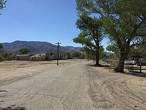
Side road in Schurz
|
|

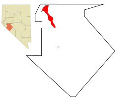
Location in Mineral County and the state of Nevada
|
|
| Country | United States |
| State | Nevada |
| County | Mineral |
| Founded | 1891 |
| Named for | Carl Schurz |
| Area | |
| • Total | 11.46 sq mi (29.68 km2) |
| • Land | 11.24 sq mi (29.10 km2) |
| • Water | 0.22 sq mi (0.57 km2) |
| Elevation | 4,127 ft (1,258 m) |
| Population
(2020)
|
|
| • Total | 656 |
| • Density | 58.38/sq mi (22.54/km2) |
| Time zone | UTC-8 (PST) |
| • Summer (DST) | UTC-7 (PDT) |
| ZIP code |
89427
|
| Area code(s) | 775 |
| FIPS code | 32-65400 |
| GNIS feature ID | 0858175 |
Schurz is a small community in Mineral County, Nevada, United States. It is a place that the government has defined for counting people, but it is not an official city. In 2020, about 656 people lived there.
Schurz is special because it is located on the Walker River Indian Reservation. This is a land set aside for the Walker River Paiute Tribe. It is also the burial place of Wovoka, an important spiritual leader of the Paiute people. He started the Ghost Dance movement, which was a religious movement among Native Americans.
History of Schurz
Schurz was started in 1891. The town got its name from Carl Schurz. He was a very important person in the United States government. He served as the United States Secretary of the Interior, which means he was in charge of managing federal lands and Native American affairs. A post office has been open in Schurz since it was founded in 1891.
Geography and Location
Schurz is in the northwestern part of Mineral County. It is located where two main roads meet: U.S. Route 95 and U.S. Route 95 Alternate.
- U.S. Route 95 goes south about 34 miles (55 km) to Hawthorne. Hawthorne is the main town and government center for Mineral County.
- U.S. Route 95 also goes north about 37 miles (60 km) to Fallon.
- U.S. Route 95 Alternate goes west about 23 miles (37 km) to Yerington.
The U.S. Census Bureau says that Schurz covers an area of about 11.5 square miles (29.8 km²). All of this area is land.
Population and People
| Historical population | |||
|---|---|---|---|
| Census | Pop. | %± | |
| 2000 | 721 | — | |
| 2010 | 658 | −8.7% | |
| 2020 | 656 | −0.3% | |
| U.S. Decennial Census | |||
In 2000, there were 721 people living in Schurz. By 2020, the population had slightly decreased to 656 people.
The people living in Schurz come from different backgrounds. A large number of the residents are Native American.
Climate in Schurz
Schurz has a semi-arid climate. This means the weather is quite dry, but not as dry as a true desert. It is often found on the edges of desert areas.
| Climate data for Schurz, Nevada | |||||||||||||
|---|---|---|---|---|---|---|---|---|---|---|---|---|---|
| Month | Jan | Feb | Mar | Apr | May | Jun | Jul | Aug | Sep | Oct | Nov | Dec | Year |
| Mean daily maximum °C (°F) | 8 (46) |
12 (53) |
16 (61) |
20 (68) |
24 (76) |
29 (84) |
34 (93) |
33 (92) |
29 (84) |
22 (72) |
15 (59) |
9 (49) |
21 (70) |
| Mean daily minimum °C (°F) | −8 (17) |
−6 (22) |
−3 (27) |
1 (33) |
5 (41) |
8 (47) |
12 (53) |
10 (50) |
5 (41) |
0 (32) |
−4 (24) |
−7 (19) |
1 (34) |
| Average precipitation mm (inches) | 13 (0.5) |
13 (0.5) |
10 (0.4) |
13 (0.5) |
15 (0.6) |
10 (0.4) |
7.6 (0.3) |
7.6 (0.3) |
7.6 (0.3) |
10 (0.4) |
10 (0.4) |
15 (0.6) |
140 (5.4) |
| Source: Weatherbase | |||||||||||||
See also
 In Spanish: Schurz (Nevada) para niños
 | Toni Morrison |
 | Barack Obama |
 | Martin Luther King Jr. |
 | Ralph Bunche |

