West Walker River facts for kids
Quick facts for kids West Walker River |
|
|---|---|

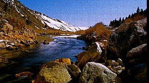
West Walker River viewed near U.S. Highway 395
|
|

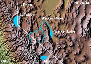
Walker River, showing the West Walker and East Walker rivers
|
|
| Country | United States |
| State | California, Nevada |
| Physical characteristics | |
| Main source | Sierra Nevada California 9,640 ft (2,940 m) 38°08′24″N 119°30′28″W / 38.14000°N 119.50778°W |
| River mouth | Walker River Yerington, Nevada 4,442 ft (1,354 m) 38°53′35″N 119°10′44″W / 38.89306°N 119.17889°W |
| Length | 95 mi (153 km) |
| Basin features | |
| Basin size | 964 sq mi (2,500 km2) |
The West Walker River is a river about 95 miles (153 km) long in California and Nevada, United States. It's like a smaller stream that flows into a bigger river called the Walker River. This river helps drain water from the Sierra Nevada mountains. All the water from the West Walker River eventually flows into Walker Lake in a large dry area called the Great Basin. The river is named after a famous explorer, Joseph R. Walker.
Where the River Starts and Flows
The West Walker River begins high up in the Sierra Nevada mountains. It starts from melting snow in northwestern Mono County, California. This area is north of Yosemite National Park.
The river then flows north. It passes by the Sweetwater Mountains on its west side. It soon reaches the Antelope Valley. This valley is a big area for ranching around the town of Walker.
The river continues flowing north past towns like Coleville and Topaz. It then crosses into southern Douglas County, Nevada. In Nevada, it turns northeast. Finally, it meets the East Walker River about 7 miles (11 km) south of Yerington. When these two rivers join, they form the main Walker River.
How the River is Used
The West Walker River is very important for farming. Its water is used a lot for irrigation in the ranching valleys. This helps crops and pastures grow in the drier areas along the river's lower path.
Some of the river's water is also sent to create Topaz Lake. This lake is located right on the border between California and Nevada. Near where the river starts in the mountains, it also gets water from a smaller stream called the Little Walker River.
Roads and the River
U.S. Highway 395 follows the West Walker River Valley. This highway connects the valley to the East Walker River through a place called Devil's Gate Pass. Other mountain passes, like Sonora Pass and Monitor Pass, lead from the valley into the Sierra Nevada mountains and the Carson River valley.
In January 1997, a huge flood happened along the West Walker River. This flood was so powerful that it destroyed about 10 miles (16 km) of U.S. Highway 395. Workers rebuilt this section of the road in just six months. The flood also carried a lot of dirt and mud into Topaz Lake. This made the lake cloudy and harmed the fish, especially the trout, living there.
 | James Van Der Zee |
 | Alma Thomas |
 | Ellis Wilson |
 | Margaret Taylor-Burroughs |

