
Sonora Pass facts for kids
Quick facts for kids Sonora Pass |
|
|---|---|
 |
|
| Elevation | 9,624 ft (2,933 m) |
| Traversed by | |
| Location | Mono / Tuolumne / Alpine counties, California, United States |
| Range | Sierra Nevada |
| Coordinates | 38°19′40″N 119°38′9″W / 38.32778°N 119.63583°W |
Sonora Pass is a high mountain pass in the Sierra Nevada mountains. It sits at an elevation of 9,624 feet (2,933 meters) above sea level. This makes it the second-highest highway pass in the Sierra Nevada.
The pass is crossed by State Route 108. It is a very important route through the mountains.
Contents
Exploring Sonora Pass
Sonora Pass connects two communities. These are Sonora on the west side and Bridgeport on the east side.
Like other high mountain passes, Sonora Pass closes in winter. Heavy snow makes the road unsafe. It usually closes from November to May each year.
The road over Sonora Pass is very steep. It has many sharp turns. Some parts of the road are very narrow. Because of this, it is not a good road for very large or heavy vehicles.

What Can You Do at Sonora Pass?
The famous Pacific Crest Trail crosses Highway 108 right at Sonora Pass. This trail is super long, stretching about 2,650 miles (4,240 km). It is a special path for hikers.
Near the pass, there is a picnic and parking area. It is a great place to stop and rest. You can also start hikes from here. Popular hikes go to Sonora Peak or Wolf Creek Lake. You can also explore other spots along the Pacific Crest Trail.

History of Sonora Pass
People have been crossing Sonora Pass for a long time. The first group to cross with wagons was the Clark-Skidmore Company. This happened in the late summer of 1852.
Some people thought the Bartleson-Bidwell Party crossed here in 1841. But the U.S. Forest Service says they crossed further north.
Building the Road
In the 1860s, silver and gold were found east of the Sierra Nevada. This led to a mining boom. People on both sides of the pass wanted a better road. They needed it to move goods and trade more easily.
Work on surveying the road began in 1863. The road was ready for use by 1865. This made travel and trade much simpler.
Old Railroad Plans
In the 1880s, a railroad company had a big idea. They wanted to build a narrow gauge railroad over Sonora Pass. This railroad would connect the San Francisco Bay Area to Utah. However, the railroad was never built. It only laid tracks in the San Francisco Bay Area.
Today, the Baker Highway Maintenance Station helps keep the road open in summer. It is a historic site.
Sonora Pass in Movies
Sonora Pass has even been in a movie! In 1943, parts of the film For Whom the Bell Tolls were filmed here. This movie was about a Spanish guerilla group. The pass was used as the location for their mountain hideout.
Images for kids
-
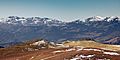
Sonora pass with fresh snow as seen from near Wheeler Peak

