Sonora Peak facts for kids
Quick facts for kids Sonora Peak |
|
|---|---|

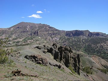
Sonora Peak from Sonora Pass
|
|
| Highest point | |
| Elevation | 11,464 ft (3,494 m) NAVD 88 |
| Prominence | 1,816 ft (554 m) |
| Listing | California county high points 10th |
| Geography | |
| Location | Alpine and Mono counties, California, U.S. |
| Parent range | Central Sierra Nevada |
| Topo map | USGS Sonora Pass |
| Climbing | |
| Easiest route | Hike, class 1-2 |
Sonora Peak is a tall mountain located in the Sierra Nevada mountain range in California. It sits right on the border between two counties, Alpine County and Mono County. This mountain is special because it is the highest point in Alpine County!
Because Sonora Peak is so high up, it gets a lot of cold weather. Most of the rain that falls on the mountain actually comes down as snow. This makes the peak look beautiful and snowy for much of the year.
Exploring Sonora Peak
Sonora Peak is a popular spot for hikers who love to explore the outdoors. It offers amazing views of the surrounding mountains and valleys. People often visit the peak to enjoy nature and challenge themselves with a climb.
How to Reach the Summit
One of the most common ways to climb Sonora Peak starts from a place called Sonora Pass. This pass is about 2 miles (3.2 kilometers) south of the peak. It's a great starting point for an adventure.
To begin your hike, you can find the start of the Pacific Crest Trail at Sonora Pass. From there, it's about a 2.5-mile (4-kilometer) hike to reach a higher pass. During this part of the hike, you will climb about 1,000 feet (305 meters) higher.
Once you reach this higher pass, the easiest path to the very top of Sonora Peak is to turn northwest. You will follow a ridge, which is like a long, narrow hilltop. About halfway along this ridge, you might even find a small trail that leads directly to the peak.
See also
 In Spanish: Pico Sonora para niños
 | Laphonza Butler |
 | Daisy Bates |
 | Elizabeth Piper Ensley |

