East Walker River facts for kids
Quick facts for kids East Walker River |
|
|---|---|

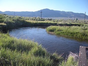
East Walker River in Bridgeport
|
|

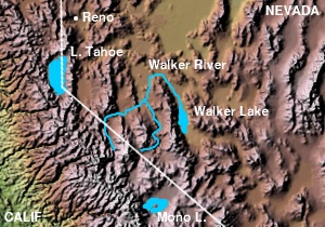
Walker River, showing the West Walker and East Walker rivers
|
|
| Country | United States |
| State | California, Nevada |
| Physical characteristics | |
| Main source | Sierra Nevada California 6,570 ft (2,000 m) 38°11′44″N 119°17′09″W / 38.19556°N 119.28583°W |
| River mouth | Walker River Yerington, Nevada 4,442 ft (1,354 m) 38°53′34″N 119°10′46″W / 38.89278°N 119.17944°W |
| Length | 90 mi (140 km), south-north |
| Basin features | |
| Basin size | 1,230 sq mi (3,200 km2) |
The East Walker River is a river about 90 miles (145 km) long. It is a branch, or tributary, of the Walker River. This river flows through eastern California and western Nevada in the United States. It helps drain the eastern side of the Sierra Nevada mountains. The water from the East Walker River eventually flows into Walker Lake in the Great Basin area.
Contents
Where the River Flows: A Journey from Mountains to Desert
The East Walker River starts from melting snow in the Sierra Nevada mountains. This area is in eastern California, close to Mono Lake and Yosemite National Park.
Starting Point: Bridgeport Valley
The main part of the river begins in the southern Bridgeport Valley. This valley is located in Mono County, California. From there, the river flows north past the town of Bridgeport. At Bridgeport, the river's water is held back to create the Bridgeport Reservoir.
Rivers Joining the East Walker
Several smaller streams flow into the East Walker River before it reaches Bridgeport Reservoir. These include Green Creek and its branch, Summers Creek. Then, Virginia Creek joins, bringing water from Dog Creek, Dunderberg Creek, and Clearwater Creek. Finally, Robinson Creek and Buckeye Creek (with its Swauger Creek branch) also add their waters to the reservoir.
Journey to Nevada
After leaving Bridgeport Reservoir, the East Walker River flows northeast. It travels through the Sweetwater Mountains. The river then crosses the state line into southern Lyon County, Nevada. It flows south of the Pine Grove Hills before turning north. Finally, it meets the West Walker River about 7 miles (13 km) south of Yerington. When these two rivers meet, they form the larger Walker River.
Roads Along the River
U.S. Highway 395 runs through the southern part of the East Walker River valley. This highway connects the valley to the Mono Lake area. It also links to the West Walker River valley through Devil's Gate Pass. Another road, California State Route 182 (also called Sweet Water Road), starts in Bridgeport. It goes northeast along the southern East Walker River valley. In Nevada, this road becomes Nevada State Route 338. However, these roads eventually turn away from the river and head northwest towards the West Walker River valley.
River Life: Animals and Nature
The East Walker River basin is home to special fish and other wildlife.
Lahontan Cutthroat Trout
By-Day Creek is a small stream that flows into Buckeye Creek. Scientists believe this creek has the last pure group of native Lahontan cutthroat trout (Oncorhynchus clarkii henshawi) in the entire Walker River basin. These fish are very special because this creek was never stocked with other types of fish. This means the trout here are truly original to the area.
In 1986, about 1,000 of these trout were counted. However, dry weather in the early 1990s likely reduced their numbers to about 250. A large part of By-Day Creek's upper area is a protected place for these trout. The California Department of Fish and Wildlife has managed this refuge since 1979. The fish from By-Day Creek are used to help restock other parts of the river system. This helps to keep the Lahontan cutthroat trout population healthy.
 | Delilah Pierce |
 | Gordon Parks |
 | Augusta Savage |
 | Charles Ethan Porter |

