Sweetwater Mountains facts for kids
Quick facts for kids Sweetwater Mountains |
|
|---|---|

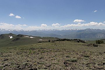
Sweetwater Mountains, looking West toward Sonora Pass.
|
|
| Highest point | |
| Peak | Mount Patterson |
| Elevation | 11,673 ft (3,558 m) |
| Geography | |
| Country | United States |
| Range coordinates | 38°25′59.696″N 119°18′3.568″W / 38.43324889°N 119.30099111°W |
| Topo map | USGS Mount Patterson |
| Geology | |
| Type of rock | igneous and volcanic |
The Sweetwater Mountains are a small mountain range located in California and Nevada. Their highest point is Mount Patterson, which stands at about 11,654 feet (3,552 meters) tall. This mountain range helps separate the West Walker River from the East Walker River.
Most of the Sweetwater Mountains are part of the Toiyabe National Forest. Getting around here often requires a four-wheel drive vehicle, hiking, or using pack animals. The name "Sweetwater Mountains" has been used on maps since at least 1874.
Contents
Exploring the Sweetwater Mountains
The Sweetwater Mountains are a great place for outdoor adventures. Because much of the area is rugged, it's perfect for those who enjoy exploring less-traveled paths.
Important Peaks in the Range
Besides Mount Patterson, the Sweetwater Mountains are home to other notable peaks. These include Middle Sister and East Sister. Each peak offers unique views and challenges for climbers and hikers.
History of Mining in the Mountains
The Sweetwater Mountains have a rich history tied to gold mining. Many small mining towns and camps once thrived here.
Ghost Towns and Old Camps
- Belfort and Clinton were small gold mining camps. They were located on the southeastern side of Mount Patterson. Both towns even had their own post offices in the 1880s.
- The Sweetwater post office was on the eastern edge of the range in the 1920s.
- The Fales post office was on the southwestern edge in 1877.
Many other small gold mines and camps existed in the area. Some of these include Boulder Flat, Montague Mine, and Tiger Mine. The area southeast of Mount Patterson was known as the Patterson Mining District. This district was very active in the late 1800s.
Understanding the Mountains' Geology
The rocks and landforms of the Sweetwater Mountains tell an interesting story about how they were formed.
How the Mountains Were Formed
The Sweetwater Mountains are mostly made of a type of rock called pluton. This rock formed deep underground from cooling magma. Around this central rock, you can find volcanic rock. This volcanic rock came from eruptions of the Little Walker Caldera. Mount Patterson itself is a volcano, though its exact age is not known. Its top is covered with a white volcanic rock called rhyolite.
 | Delilah Pierce |
 | Gordon Parks |
 | Augusta Savage |
 | Charles Ethan Porter |


