Churchill County, Nevada facts for kids
Quick facts for kids
Churchill County
|
|||
|---|---|---|---|

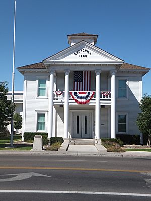
Churchill County Courthouse in Fallon
|
|||
|
|||

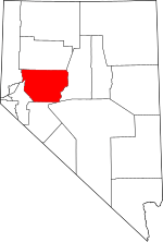
Location within the U.S. state of Nevada
|
|||
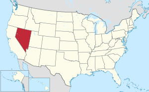
 Nevada's location within the U.S. |
|||
| Country | |||
| State | |||
| Founded | 1861 (created) 1864 (organized) |
||
| Named for | Sylvester Churchill | ||
| Seat | Fallon | ||
| Largest city | Fallon | ||
| Area | |||
| • Total | 5,024 sq mi (13,010 km2) | ||
| • Land | 4,930 sq mi (12,800 km2) | ||
| • Water | 94 sq mi (240 km2) 1.9% | ||
| Population
(2020)
|
|||
| • Total | 25,516 | ||
| • Density | 5.0788/sq mi (1.96094/km2) | ||
| Time zone | UTC−8 (Pacific) | ||
| • Summer (DST) | UTC−7 (PDT) | ||
| Congressional district | 2nd | ||
Churchill County is a county located in the western part of Nevada, a U.S. state. In 2020, about 25,516 people lived there. The main town and county seat (the center of county government) is Fallon. The county was created in 1861 and was named after Sylvester Churchill, a hero from the Mexican–American War. Churchill County is special because it owns and runs its own local phone company, Churchill County Communications.
Contents
History of Churchill County
Churchill County was set up in 1861. It was named after Fort Churchill, which is now in a different county called Lyon County. Fort Churchill itself was named after General Sylvester Churchill. He was a very important military leader, serving as the Inspector General of the U.S. Army in 1861.
Even though the county was created in 1861, it wasn't fully organized until 1864. Its first county seat was a place called Bucklands. Over the years, the county seat moved a few times:
- In 1864, it moved to La Plata.
- In 1868, it moved to Stillwater.
- Finally, in 1904, it moved to its current location, Fallon.
In the 1800s, some people tried to get rid of Churchill County because it didn't have many people. But a leader named Lemuel Allen always stopped these attempts. He even convinced the Governor to say "no" to a bill in 1875 that would have closed the county.
Railroads in the County
Railroads played a part in the county's history. The Eagle Salt Works Railroad was a short line, about 13.5 miles (21.7 km) long. It mainly followed an old path from the Central Pacific Railroad.
The Central Pacific was part of the first railroad that went all the way across the country. A section of this important railroad ran through Churchill County. Later, the Central Pacific became the Southern Pacific Railroad, which then joined with Union Pacific in 1996.
Geography of Churchill County
Churchill County has a varied landscape. You'll find rugged mountains and many lakes and ponds. The eastern and western parts of the county are higher than the valley in the middle. The highest point in the county is Desatoya Peak, which is about 9,977 feet (3,041 meters) tall. Another tall peak is Mount Augusta, at about 9,970 feet (3,039 meters).
The county covers a total area of about 5,024 square miles (13,010 square kilometers). Most of this is land (4,930 square miles or 12,770 square kilometers), and a smaller part is water (94 square miles or 240 square kilometers).
Main Roads
Many important roads run through Churchill County, connecting it to other parts of Nevada and beyond. These include:
 Interstate 11 (Future)
 Interstate 80
 U.S. Route 50
 U.S. Route 50 Alternate
 U.S. Route 95
 U.S. Route 95 Alternate
 State Route 115
 State Route 116
 State Route 117
 State Route 118
 State Route 119
 State Route 120
 State Route 121
 State Route 361
 State Route 715
 State Route 718
 State Route 720
 State Route 722
 State Route 723
 State Route 726
 State Route 839
Neighboring Counties
Churchill County shares borders with several other counties:
- Lyon County – to the west
- Washoe County – to the northwest
- Pershing County – to the north
- Lander County – to the east
- Nye County – to the southeast
- Mineral County – to the south
Protected Natural Areas
The county is home to several areas set aside to protect nature and wildlife:
- Fallon National Wildlife Refuge
- Humboldt State Wildlife Management Area
- Lahontan State Game Refuge
- Lahontan State Recreation Area (part of it)
- Sand Mountain Recreation Area
- Stillwater National Wildlife Refuge
Lakes and Reservoirs
Many bodies of water are found in Churchill County, including:
- Big Water
- Carson Lake
- Cattail Lake
- Division Lake
- Dog Head Pond
- Dry Lake
- Dutch Bill Lake
- East Alkali Lake Number One
- East Alkali Lake Number Two
- Foxtail Lake
- Goose Lake
- Humboldt Lake (part of it)
- Lahontan Reservoir
- Little Soda Lake
- North Nutgrass Lake
- Pintail Bay
- Scheckler Reservoir
- Soda Lake
- Stillwater Point Reservoir
- Swan Check
- Swan Lake
- Tule Lake
- West Nutgrass
- Willow Lake
People of Churchill County
| Historical population | |||
|---|---|---|---|
| Census | Pop. | %± | |
| 1870 | 196 | — | |
| 1880 | 479 | 144.4% | |
| 1890 | 703 | 46.8% | |
| 1900 | 830 | 18.1% | |
| 1910 | 2,811 | 238.7% | |
| 1920 | 4,649 | 65.4% | |
| 1930 | 5,075 | 9.2% | |
| 1940 | 5,317 | 4.8% | |
| 1950 | 6,161 | 15.9% | |
| 1960 | 8,452 | 37.2% | |
| 1970 | 10,513 | 24.4% | |
| 1980 | 13,917 | 32.4% | |
| 1990 | 17,938 | 28.9% | |
| 2000 | 23,982 | 33.7% | |
| 2010 | 24,877 | 3.7% | |
| 2020 | 25,516 | 2.6% | |
| 2023 (est.) | 25,803 | 3.7% | |
| US Decennial Census 1790-1960 1900-1990 1990-2000 2010-2018 |
|||
In 2010, the county had 24,877 people living in 9,671 homes. About 6,631 of these were families. The population density was about 5 people per square mile.
Most people in the county (82%) were white. Other groups included American Indian (4.5%), Asian (2.7%), and Black or African American (1.6%). About 12.1% of the population identified as Hispanic or Latino. Many people had ancestors from England (19.2%), Germany (18.8%), or Ireland (13.6%).
The average age in the county was 39 years old. The median household income was $51,597, meaning half of the households earned more than this and half earned less. The median family income was $63,599.
Communities in Churchill County
City
Census-designated place
- Fallon Station
Unincorporated communities
These are smaller towns or areas that are not officially organized as cities:
- Cold Springs
- Dixie Valley
- Eastgate
- Hazen
- Middlegate
- Stillwater
Education
The schools in Churchill County are part of the Churchill County School District. The public high school for the county is Churchill County High School.
There is also a special type of school called a charter school in Fallon, known as Oasis Academy.
See also

- In Spanish: Condado de Churchill para niños
 | Aurelia Browder |
 | Nannie Helen Burroughs |
 | Michelle Alexander |


