Yosemite West, California facts for kids
Quick facts for kids
Yosemite West
|
|
|---|---|

Local map
|
|
| Country | United States |
| State | California |
| County | Mariposa County |
| Area | |
| • Total | 0.274 sq mi (0.71 km2) |
| • Land | 0.274 sq mi (0.71 km2) |
| • Water | 0 sq mi (0 km2) 0% |
| Elevation | 5,866 ft (1,788 m) |
| Population
(2020)
|
|
| • Total | 47 |
| • Density | 171.5/sq mi (66.2/km2) |
| Time zone | UTC-8 (Pacific (PST)) |
| • Summer (DST) | UTC-7 (PDT) |
| ZIP code |
95389 (Yosemite National Park)
|
| Area code | 209 |
| GNIS feature IDs | 252493, 2813254 |
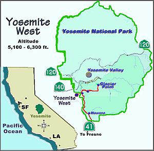
Yosemite West is a small community with vacation homes. It is located right next to the southern part of Yosemite National Park. You can find it just off Wawona Road, which is also known as California State Route 41. This area is considered a census-designated place, meaning it is a special type of community.
In 2020, only 47 people lived in Yosemite West. It sits about 1 mile (1.6 km) south of the Chinquapin area. The community is high up, between 5,100 and 6,300 feet (1,554 to 1,920 meters) above sea level. The official elevation is 5,866 feet (1,788 meters). Yosemite West is part of Henness Ridge, which is nearly 3,000 feet (914 meters) above the Merced River. Even though it is a separate community, its mailing address is "Yosemite National Park, CA 95389."
Contents
History of Logging and the Yosemite Railroad
A long time ago, around 1912, people started cutting down trees in the Chinquapin area. They would haul these logs to Merced Falls. The Yosemite Valley Railroad was built to help move the huge amounts of sugar pine wood found in the Merced River canyon. The Yosemite Lumber Company was the main company that worked here.
The company used a special incline, which was like a steep railway, to lower logs. This incline dropped logs 3,100 feet (945 meters) down to the Merced River at El Portal. One of the stops on the Yosemite Valley Railroad was a large lumber mill. Here, the wood was cut, smoothed, dried, and stored.
Today, the lumber company is gone. The trees have grown back, with many now taller than 80 feet (24 meters). The old paths where the logging trains once ran have been replaced with paved roads.
Exploring Hiking Trails Near Yosemite West
Yosemite West is a private community, but several hiking trails start right at its edge. Some of these trails follow the old paths left by the Yosemite Lumber Company.
Deer Camp Trail Adventure
One popular trail is the Deer Camp Trail. You can find its starting point across Highway 41, near the turnoff for Henness Ridge Road. There is a parking area there. This trail is just south of Chinquapin and Glacier Point Road. As you hike, the trail crosses over Rail Creek and Strawberry Creek. It eventually leads to Deer Camp on Empire Meadow.
Alder Creek Trail and Old Railroad Remnants
The Alder Creek Trail branches off from the Deer Camp Trail. This path takes you to Alder Creek Fall. Along the way, you can still see parts of the old Yosemite Lumber Company railroad. Look closely for old railroad ties and pieces of track!
In the past, some areas along this trail were almost completely cleared of trees by the lumber company. But now, the forest has grown back. You will see many tall evergreen trees and some oak trees. The trail is not too hard to hike, and the ground is mostly smooth.
Henness Ridge Fire Lookout Hike
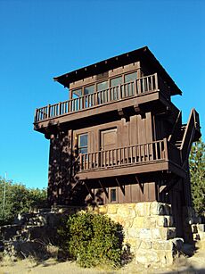
Another interesting hike is the Henness Ridge Fire Lookout Trail. This trail does not have a sign at the start. It begins at the very end of Azalea Lane in Yosemite West. To find it, walk along the paved access road to your right. You will pass some water towers. Keep going for about 0.7 miles (1.1 km) until you reach the Henness Ridge fire lookout tower.
This tower was built in 1939 by the CCC (Civilian Conservation Corps). The National Park Service used it to spot forest fires. Today, it is recognized as a historic building.
Eleven-Mile Trail: A Journey Through Time
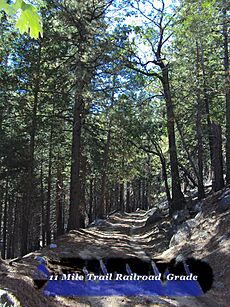
There is another trail that also starts from Azalea Road. Take the path to your left and walk about a quarter-mile (0.4 km) northeast. The trail will then turn south. You are now on the Eleven-mile Trail, which is also known as the Old Wawona Road. This old road runs next to the current Wawona Road.
Follow this old road south. The trail splits when you reach Eleven-mile Creek. One path follows the creek bed and leads to Eleven-mile Meadow.
Eleven-mile Meadow has been used for many different things over the years. In the early 1900s, it was used for grazing cattle. It was also a logging camp and a CCC camp, which was set up in 1933. Even earlier, in the late 1800s, stagecoaches brought travelers to the area. They would stop at the Eleven Mile Change Station, which was near Chinquapin. Later, this road was turned into a rail bed. The Yosemite Lumber Company used it to transport logs to the incline at Henness Ridge. This incline then lowered the logs to the Merced River far below.
 | Lonnie Johnson |
 | Granville Woods |
 | Lewis Howard Latimer |
 | James West |


