
Lassen Volcanic National Park facts for kids
Quick facts for kids Lassen Volcanic National Park |
|
|---|---|
|
IUCN Category II (National Park)
|
|

Lake Helen in Lassen Volcanic National Park
|
|

Lassen Volcanic National Park
Location in California

Lassen Volcanic National Park
Location in the United States
|
|
| Location | Shasta, Lassen, Plumas, and Tehama counties, California, United States |
| Nearest city | Redding and Susanville |
| Area | 106,452 acres (430.80 km2) |
| Established | August 9, 1916 |
| Visitors | 499,435 (in 2018) |
| Governing body | National Park Service |
| Website | Lassen Volcanic National Park |


.jpg)
Lassen Volcanic National Park is a special place in northeastern California, United States. Its main feature is Lassen Peak, which is the largest plug dome volcano in the world. It's also the southernmost volcano in the Cascade Range.
What makes Lassen Volcanic National Park unique is that you can find all four main types of volcanoes here:
- Plug dome (like Lassen Peak itself)
- Shield volcanoes
- Cinder cones
- Stratovolcanoes
The heat for these volcanoes comes from deep underground. It's caused by the Gorda Plate slowly sliding beneath the North American Plate off the coast of Northern California. Even today, the area around Lassen Peak is active. You can see boiling mud pots, steaming vents called fumaroles, and bubbling hot springs.
Lassen Volcanic National Park began as two separate national monuments. President Theodore Roosevelt created them in 1907. They were called Cinder Cone National Monument and Lassen Peak National Monument. From 1914 to 1917, Lassen Peak had many eruptions. Because of these eruptions and the beautiful volcanic landscape, the area became a National Park on August 9, 1916.
Contents
History of Lassen Volcanic National Park
Native Americans lived in this area long before European settlers arrived. They knew that Lassen Peak was full of fire and water. They believed it would one day explode.
Early Explorers and Settlers
In the mid-1800s, European immigrants used Lassen Peak as a landmark. They were traveling to the rich Sacramento Valley. One guide for these travelers was Peter Lassen, a Danish blacksmith. He settled in Northern California in the 1830s. Lassen Peak was named after him. Later, the Nobles Emigrant Trail was built through the park area. It passed by Cinder Cone and the Fantastic Lava Beds.
Volcanic Activity and Park Creation
Newspaper stories from 1850 to 1851 reported seeing "fire thrown to a terrible height" near Cinder Cone. They also mentioned "burning lava running down the sides." Scientists later studied Cinder Cone. They believed its last eruption happened between 1630 and 1670. Tree-ring studies now suggest the eruption was in 1666.
The Lassen area was first protected as the Lassen Peak Forest Preserve. Then, in May 1907, President Theodore Roosevelt made Lassen Peak and Cinder Cone into U.S. National Monuments.
From May 1914 to 1921, Lassen Peak had many eruptions. Some were small, others were large. These events created a new crater. They also released lava and a lot of ash. Luckily, warnings helped keep people safe. No one was killed, but some houses were destroyed. Because of this volcanic activity, the area became a National Park on August 9, 1916.
Building Roads and Protecting Wilderness
The main park road is 29-mile (47 km) long. It was built between 1925 and 1931. This was just 10 years after Lassen Peak erupted. Near Lassen Peak, the road reaches 8,512 feet (2,594 m) high. This makes it the highest road in the Cascade Mountains. It's common for 40 ft (12 m) of snow to pile up near Lake Helen. Snow patches can even last into July.
In 1972, part of the park became the Lassen Volcanic Wilderness. The National Park Service manages this area to keep it wild. There are few buildings, signs, or trails. The goal is to offer a challenging and adventurous experience.
In 1974, the National Park Service closed the visitor center at Manzanita Lake. Scientists from the USGS advised this. They said the buildings could be hit by a rockslide from Chaos Crags if there was an earthquake or eruption. Today, a campground, store, and museum stand near Manzanita Lake. They welcome visitors entering the park from the northwest.
After the 1980 eruption of Mount St. Helens, the USGS started watching volcanoes more closely. They now monitor the Lassen area for changes. This includes checking ground movement and volcanic gases. They also use seismometers to detect earthquakes. If volcanic activity increases, scientists are ready to respond quickly. The National Park Service also has a plan to protect visitors during an eruption.
The Lassen Chalet, a large lodge, was taken down in 2005. A new visitor center opened in 2008 in the same spot. A ski area near the lodge closed in 1992. All its buildings have been removed.
Geography and Geology of Lassen Volcanic National Park

The park is located near the northern end of the Sacramento Valley. It's close to the cities of Redding and Susanville. The park stretches across parts of four counties: Shasta, Lassen, Plumas, and Tehama.
Western Park Features
The western part of the park has amazing lava pinnacles. These are huge mountains formed by lava flows. You'll also see jagged craters and steaming sulfur vents. This area has deep canyons carved by glaciers. It's also filled with beautiful lakes and clear, rushing streams.
Eastern Park Features
The eastern part of the park is a huge lava plateau. It sits more than one mile (1.6 km) above sea level. Here, you can find smaller cinder cone volcanoes like Fairfield Peak and Hat Mountain. This area is covered with pine and fir trees. It has many small lakes but few streams. Warner Valley, at the southern edge of the Lassen Plateau, has hot spring areas. These include Boiling Springs Lake and Devils Kitchen. This forested valley also has large meadows that burst with wildflowers in spring.
Lassen Peak and Ancient Volcanoes
Lassen Peak is made of a rock called dacite. It is one of the world's largest plug dome volcanoes. It's also the southernmost active volcano in the Cascade Range. This 10,457-foot (3,187 m) tall volcano sits on the side of what's left of Mount Tehama. Mount Tehama was a much larger stratovolcano. It was about 1,000 feet (300 m) taller than Lassen Peak. It was also 11 to 15 miles (18 to 24 km) wide at its base.
About 350,000 years ago, Mount Tehama's top collapsed. This formed a two-mile (3.2 km) wide caldera. This happened after many eruptions emptied its magma chamber. Or, it might have slowly worn away due to acidic gases and glaciers.

Sulphur Works is a geothermal area between Lassen Peak and Brokeoff Mountain. It's believed to be near the center of the old Tehama volcano. Other hot spots in the caldera include Little Hot Springs Valley and Bumpass Hell.
The magma that feeds the park's volcanoes comes from deep under the ocean. It's part of the subduction process off the coast of Northern California. Cinder Cone and the Fantastic Lava Beds is about 10 miles (16 km) northeast of Lassen Peak. This cinder cone last erupted around 1650. It created the Fantastic Lava Beds, which are made of basaltic andesite lava.
There are four shield volcanoes in the park:
- Mount Harkness
- Red Mountain
- Prospect Peak
- Raker Peak
All these volcanoes are between 7,000 and 8,400 feet (2,133–2,560 m) high. Each one has a cinder cone on top.
During past ice ages, glaciers helped shape the older volcanoes in the park. Lassen Peak, Red Mountain, and Raker Peak show the most signs of glacial carving. Even though there are no glaciers today, Lassen Peak still has 14 permanent snowfields.

How to Get to the Park
You can reach the park using State Routes 89 and 44. SR 89 goes through the park from north to south. It passes right next to Lassen Peak. There are five ways to drive into the park. You can also enter by trails from the Caribou Wilderness to the east. The Pacific Crest Trail also passes through the park.
Climate and Weather
Lassen Volcanic National Park has cool to cold winters and warm summers. This is because the whole park is at medium to high elevations. Above 7,500 feet (2,286 m), the weather is very cold, even in summer.
The park gets a lot of rain and snow. This is because there are no mountains blocking the moisture from the Pacific Ocean. Lassen gets more precipitation than any other place in the Cascades south of the Three Sisters.
Near the southwest entrance, at 6,700 feet (2,040 m), the snowfall is about 430 inches (1,090 cm). Up at Lake Helen, at 8,200 feet (2,499 m), the snowfall is around 600–700 inches (1,520–1,780 cm). This makes it likely the snowiest place in California. Lake Helen also gets more average snow than any other station near a Cascade volcano. Snow can stay on the ground all year long.
Plants of Lassen Volcanic National Park
Lassen Volcanic National Park is at the northern end of the Sierra Nevada forests. It has 27,130 acres (10,980 ha) of old growth forests. These forests look much like they did before European settlers arrived.
Forests at Lower Elevations
Below 6,500 feet, you'll find a mixed conifer forest. The main trees are Ponderosa and Jeffrey Pines, Sugar Pines, and White Firs. This forest is rich with other plants too. You might see different kinds of manzanita, gooseberry, and ceanothus. Common wildflowers include iris, spotted coralroot, pyrola, violets, and lupin.
Forests at Higher Elevations
Above the mixed-conifer forest is the Red Fir forest. Between 6,500 and 8,000 feet, the main trees are Red Fir, Western White Pine, Mountain Hemlock, and Lodgepole Pine. This area has fewer types of plants than the lower forests. You might find satin lupine, woolly mule's-ears, and pinemat manzanita.
Subalpine Areas
Subalpine areas are where trees reach their highest growing limit. From 8,000 feet up to the treeline, there are fewer plants. Large patches of bare ground make it a tough place to live. Some tough plants here include Rock spirea, lupin, Indian paintbrush, and penstemon. Trees like Whitebark Pine and Mountain Hemlock also grow here.
Wildlife of Lassen Volcanic National Park

Many animals live in the park's forests. You might see:
- Black bears
- Red foxes
- Mule deer
- Martens
- Cougars
- Brown creepers
- Different types of chipmunks
- Raccoons
- Mountain chickadees
- Pikas
- Various squirrel species
- White-headed woodpeckers
- Coyotes
- Bobcats
- Weasels
- Many types of mousees
- Long-toed salamanders
- Skunks
- A wide variety of bat species
Lassen Volcanic Park is especially important for the Sierra Nevada red fox. This is one of the rarest mammals in California. Scientists have found 20 of these foxes in the park. This makes it the largest known group of Sierra Nevada red foxes.
Geology of Lassen Volcanic National Park

The land in Lassen Volcanic National Park has been shaped by millions of years of geological activity.
How the Rocks Formed
Long ago, the Sierra Nevada mountains were lifted up. Also, a lot of volcanic activity happened. This created huge mud flows (called lahars) during the Pliocene era. These mud flows formed the Tuscan Formation. This rock layer is not seen on the surface in the park, but it's just below.
Also in the Pliocene, basaltic lava flows erupted from cracks in the southern part of the park. These flows covered large areas and built a wide lava plateau. Later, these basalt flows were covered by thick, flowing andesite lava. This created a relatively flat lava plain.
How the Volcanoes Grew
Then, volcanic eruptions started piling up tephra (volcanic rock fragments) into cones in the northern part of the park.
Mount Tehama (also called Brokeoff Volcano) grew as a large stratovolcano in the park's southwest corner. It was made of layers of andesite lavas and tephra. At its biggest, Tehama was probably about 11,000 feet (3,400 m) high.
About 350,000 years ago, its cone collapsed. This formed a two-mile (3.2 km) wide caldera. This happened after many eruptions emptied its magma chamber. One of these eruptions happened where Lassen Peak is now. It created a thick layer of black, glassy dacite lava.
During the last ice age, glaciers changed the older volcanoes in the park. This includes what's left of Tehama. Many of these glacial features have since been covered by new volcanic ash or destroyed by eruptions.
Around 27,000 years ago, Lassen Peak began to form. It grew quickly as a dacite lava dome. It pushed its way through the side of the old Tehama volcano. As the lava dome rose, it broke apart the rock above it. This created a pile of loose rock around the new volcano. Lassen Peak reached its current height very fast, possibly in just a few years. Glaciers from the Ice Age also partly eroded Lassen Peak.
Since then, smaller dacite domes have formed around Lassen. The biggest of these is Chaos Crags, just north of Lassen Peak. Steam explosions, dacite and andesite lava flows, and cinder cone formation have continued into modern times.

The Lassen area still has active hot springs and mud pots. Some of these springs are home to tiny living things called extremophiles. These amazing organisms can survive in extremely hot places!
Images for kids
-
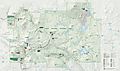
Map of Lassen Volcanic National park

See also
 In Spanish: Parque nacional volcánico Lassen para niños
