Plumas County, California facts for kids
Quick facts for kids
Plumas County, California
|
||
|---|---|---|
| County of Plumas | ||
|
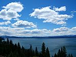
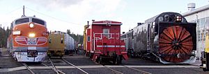
Images, from top down, left to right: Lake Almanor, Beckwourth Pass, Trains at the Western Pacific Railroad Museum
|
||
|
||

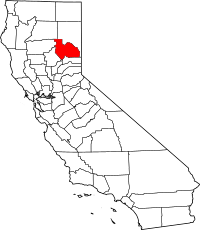
Location in the state of California
|
||
| Country | ||
| State | ||
| Region | Sierra Nevada | |
| Incorporated | March 18, 1854 | |
| Named for | Spanish words for the Feather River (Río de las Plumas) | |
| County seat | Quincy | |
| Largest community | East Quincy (population) Warner Valley (area) Portola (incorporated) |
|
| Government | ||
| • Type | Council–Administrator | |
| Area | ||
| • Total | 2,613 sq mi (6,770 km2) | |
| • Land | 2,553 sq mi (6,610 km2) | |
| • Water | 60 sq mi (200 km2) | |
| Highest elevation | 8,372 ft (2,552 m) | |
| Population | ||
| • Total | 19,790 | |
| • Density | 7.574/sq mi (2.9242/km2) | |
| GDP | ||
| • Total | $1.121 billion (2022) | |
| Time zone | UTC-8 (Pacific Standard Time) | |
| • Summer (DST) | UTC-7 (Pacific Daylight Time) | |
| Congressional district | 3rd | |
| Website | www.countyofplumas.com | |
Plumas County is a county in the Sierra Nevada mountains of California, USA. Its name comes from the Spanish words Río de las Plumas, which means "River of Feathers." This is the name of the Feather River that flows through the area.
As of 2020, about 19,790 people live here. The main town and county seat is Quincy. The only official city in Plumas County is Portola. The largest community by population is East Quincy.
Contents
History of Plumas County
Early Inhabitants: The Mountain Maidu
Long ago, the Mountain Maidu people were the first to live in the area that is now Plumas County. They lived in small villages near valleys. The Maidu found food like roots, acorns, and seeds. Sometimes, they also fished or hunted large animals. They did not have one main leader for their whole tribe. Instead, different groups lived along waterways in their own valleys. Areas with lots of snow, like the Mohawk and Sierra valleys, were used for hunting in warmer months.
The California Gold Rush Arrives
In 1848, people from Europe and America found gold in the Sierra foothills. Many miners came to Plumas County because of stories about a lake full of gold nuggets. This story was told by Thomas Stoddard. Even though miners searched for months, they never found this golden lake.
However, some miners did find gold by panning in the rivers and creeks. They built small villages, which were the first non-Native American settlements in the area. These rough towns quickly grew around successful mining spots. Some of these places were Rich Bar, Indian Bar, and Rabbit Creek (now La Porte). Many of these towns were built next to the Feather River.
James Beckwourth and the Beckwourth Pass
In 1850, a brave African-American explorer named James Beckwourth found the lowest way to cross the Sierra Nevada mountains. This path became known as Beckwourth Pass. He created a trail from Western Nevada through much of Plumas County. The trail ended in the Sacramento Valley. Many miners used this trail to get into Plumas County. Beckwourth also set up a trading post that is still there today.
The Beckwourth Trail was longer than other trails. But because it was at a lower elevation, people could use it even when higher trails were covered in snow. Between 1851 and 1854, many people traveled on the Beckwourth Trail. However, in 1854, it became a toll road, meaning people had to pay to use it. This made it too expensive for many, and its use quickly dropped.
Forming Plumas County
Plumas County was officially created on March 18, 1854. It was made from the eastern part of Butte County. Quincy, which started as a mining town, was chosen as the county seat. An early settler gave land in Quincy to build the county government buildings. After Quincy became the county seat, a nearby town called Elizabethtown slowly disappeared.
In 1864, a large part of Plumas County was used to create Lassen County. Soon after, Plumas County gained a part of Sierra County, including the busy mining town of La Porte.
Growth and Industries
Over the next few decades, different industries helped towns in Plumas County grow.
- Greenville started as a mining and farming community in the late 1850s.
- Chester grew near what is now Lake Almanor. It was important for cattle ranching and the timber (lumber) industry.
When the Western Pacific Railroad was built in 1910, Portola became a very important railroad stop. Thanks to the railroad, Plumas County could send its lumber to other places. The timber industry became the main part of the county's economy for many years. The railroad also brought the first tourists to the beautiful Feather River Canyon.
In 1937, the Feather River Highway was finished. This highway connected Plumas County to the Sacramento Valley all year round. This was a big help for the county's economy and travel.
Geography and Nature
Plumas County covers about 2,613 square miles. Most of this is land, with about 60 square miles of water.
The county is located in the northern part of the Sierra Nevada mountains. This area is rugged and marks where the Sierra Nevada mountains meet the southern end of the Cascade Range. Lassen Peak, a volcano, is just north of Plumas County. A part of Lassen Volcanic National Park is also in the county's northwest corner.
Outdoor Adventures in Plumas County
Plumas National Forest covers 1.2 million acres in the county. It offers many ways to enjoy the outdoors:
- Hiking and camping
- Kayaking and swimming
- Mountain biking
- Hunting and fishing
The area has more than 100 natural and human-made lakes. Many natural lakes were formed by glaciers. You can find them around the Lakes Basin Recreation Area. Some of the larger lakes include Lake Almanor, Lake Davis, Frenchman Lake, Little Grass Valley Reservoir, Antelope Lake, and Bucks Lake.
Plumas County also has over 1,000 miles of rivers and streams. All three branches of the Feather River flow through the county.
Special Natural Places
- Butterfly Valley Botanical Area
- Elephants Playground
- Happy Valley
- Little Last Chance Canyon Special Interest Area
- North Valley
- Valley Creek Special Interest Area
Lakes and Rivers
- Antelope Lake
- Belden Forebay
- Bucks Lake
- Butt Valley Reservoir
- Doyle Reservoir
- Eureka Lake
- Faggs Debris Dam
- Faggs Reservoir
- Fowler Lake
- Frenchman Lake
- Grizzly Forebay
- Grizzly Ice Pond
- Juniper Lake
- Lake Almanor
- Lake Davis
- Little Grass Valley Reservoir
- Lower Bucks Lake
- Murphy Lake
- Onion Valley Reservoir
- Rock Creek Reservoir
- Round Valley Reservoir
- Silver Lake
- Slate Creek Reservoir
- Smith Lake
- Three Lakes
- Walker Mine Tailings Reservoir
Neighboring Counties
Plumas County shares borders with these other counties:
- Sierra County – to the south
- Yuba County – to the southwest
- Butte County – to the west
- Tehama County – to the northwest
- Shasta County – to the northwest
- Lassen County – to the northeast
Protected Natural Areas
Parts of these national protected areas are found in Plumas County:
- Lassen National Forest
- Lassen Volcanic National Park
- Plumas National Forest
- Tahoe National Forest
Population and People
Plumas County has a population of 19,790 people, based on the 2020 census.
Who Lives in Plumas County?
The 2020 census showed the following groups living in Plumas County:
- White (not Hispanic or Latino): 80.84%
- Hispanic or Latino (of any race): 9.59%
- Mixed race or Multiracial (not Hispanic or Latino): 5.61%
- Native American or Alaska Native (not Hispanic or Latino): 1.93%
- Asian (not Hispanic or Latino): 0.73%
- Other Race (not Hispanic or Latino): 0.58%
- Black or African American (not Hispanic or Latino): 0.52%
- Pacific Islander (not Hispanic or Latino): 0.20%
In 2000, the average age in the county was 44 years old. About 22.7% of the population was under 18.
Culture and Attractions
Plumas County has interesting places to visit and learn about its history.
- The town of Portola is home to the Western Pacific Railroad Museum. This is one of the biggest railroad museums in North America and a popular place for tourists.
- In Chester, you can find the Collins Pine Museum. It teaches visitors about the history of the Collins Pine Company's logging work in the area.
- The Plumas County Museum in Quincy has exhibits about the Maidu people, the California Gold Rush, and the history of logging. It also shows modern art.
News and Education
Local News
The main local news source for Plumas County has been Feather Publishing Co., Inc. since 1866. They used to publish several newspapers. While the newspapers stopped in 2023, Feather Publishing still creates other guides like High Country Life and The Visitor Guide. They also do commercial printing for the community.
Plumas County is part of the Sacramento television market. This means people in Plumas County get news from Sacramento TV stations like KXTV and KCRA.
Colleges and Schools
- Feather River College is located in Plumas County.
Getting Around Plumas County
Main Roads
 State Route 36
 State Route 49
 State Route 70
 State Route 89
 State Route 284
Beautiful Scenic Drives
- The Feather River National Scenic Byway follows the Middle and North Forks of the Feather River. This drive goes through steep canyons and high mountain valleys. You will see grasslands, oak forests, and mixed conifer trees. It starts in the Sacramento Valley and enters Plumas County near Storrie. The route climbs over the Sierra mountains and passes through Quincy and Portola. It ends at Hallelujah Junction.
- The Volcanic Legacy Scenic Byway starts in Plumas County at Lake Almanor. This long route, about 500 miles, goes through California and Oregon. It offers amazing views of volcanic landscapes, including nearby Lassen Peak.
- The Scenic Byway Link is a section of Highway 89. It connects the Volcanic Legacy and Feather River Scenic Byways. This 18-mile route features pretty alpine meadows in Indian Valley. You can also see the rushing waters of Indian Creek and views of Mt. Hough.
Public Transportation
Plumas Transit Systems provides local bus service in Quincy and routes to Chester and Portola.
Airports
- Gansner Field is a general aviation airport near Quincy.
- Rogers Field is near Chester. Besides being a civil airport, it also helps the California Department of Forestry with aerial firefighting. This base provides fuel, fire retardant, and communication for air and ground firefighting teams.
- Nervino Airport is in Beckwourth, east of Portola.
- The closest major airport for bigger flights is Reno–Tahoe International Airport.
Towns and Communities
City
Census-Designated Places (CDPs)
These are areas that are like towns but are not officially incorporated as cities.
- Beckwourth
- Belden
- Blairsden
- Bucks Lake
- Canyondam
- Caribou
- Chester
- Chilcoot-Vinton
- Clio
- Crescent Mills
- C-Road
- Cromberg
- Delleker
- East Quincy
- East Shore
- Gold Mountain
- Graeagle
- Greenhorn
- Greenville
- Hamilton Branch
- Indian Falls
- Iron Horse
- Johnsville
- Keddie
- La Porte
- Lake Almanor Country Club
- Lake Almanor Peninsula
- Lake Almanor West
- Lake Davis
- Little Grass Valley
- Mabie
- Meadow Valley
- Mohawk Vista
- Paxton
- Plumas Eureka
- Prattville
- Quincy (the county seat)
- Spring Garden
- Taylorsville
- Tobin
- Twain
- Valley Ranch
- Warner Valley
- Whitehawk
Unincorporated Communities
These are small communities that are not officially part of a city or CDP.
- American House
- Buckeye
- Cascade
- Drakesbad
- Feather River Park
- Gate Place
- Genesee
- Longville
- Massack
- Palmetto
- Prospect
- Rock Creek
- Seneca
- Sloat
- Spanish Ranch
Ghost Towns
See also
 In Spanish: Condado de Plumas para niños
 | Anna J. Cooper |
 | Mary McLeod Bethune |
 | Lillie Mae Bradford |


