Beckwourth Pass facts for kids
Quick facts for kids Beckwourth Pass |
|
|---|---|

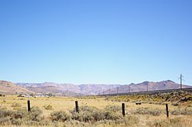
Beckwourth Pass as seen from the Feather River Route in the Sierra Valley looking east
|
|
| Elevation | 5,221 ft (1,591 m) |
| Traversed by | Feather River Route |
| Location | Plumas County |
| Range | Sierra Nevada (U.S.) |
| Coordinates | 39°47′30″N 120°6′28″W / 39.79167°N 120.10778°W |
| Reference #: | 336 |
Beckwourth Pass is a special place in the Sierra Nevada mountains. It's the lowest mountain pass in this big mountain range. This means it's the easiest way to cross over the mountains in this area. The pass is about 5,221 feet (1,591 m) high.
You can find Beckwourth Pass in Plumas County, California. It's on the eastern side of a place called Sierra Valley. The pass is about 20 miles (32 km) east of Portola, California and 25 miles (40 km) northwest of Reno, Nevada.
A road called California State Route 70 goes right over Beckwourth Pass. Also, a train track called the Feather River Route goes under the pass. It uses a special tunnel called the Chilcoot Tunnel. This road and train line are super helpful. They offer another way to travel between Sacramento, California and Reno, Nevada. This is especially useful when the main highway, Interstate 80, is closed because of heavy snow in winter.
Contents
Discovering Beckwourth Pass
Who Found the Pass?
A man named James Beckwourth found Beckwourth Pass in 1850. He was an explorer and a mountain man. The pass was originally a path used by Native Americans. In 1851, James Beckwourth made this path much better. He turned it into a trail for wagons. This new route was called the Beckwourth Trail.
The Beckwourth Trail
The Beckwourth Trail started in Truckee Meadows. Today, this area is known as Sparks, Nevada. From there, the trail went through the new pass. It continued into California and ended in Marysville.
In the late summer of 1851, James Beckwourth led the very first group of settlers. They traveled with their wagons along the new Beckwourth Trail. They were heading to Marysville to start new lives.
Changes to the Trail
From 1851 to 1854, many people used the Beckwourth Trail. It was a popular way to cross the mountains. But in 1854, things changed. The Beckwourth Trail became a toll road. This meant people had to pay to use it.
Moving goods on the Beckwourth Road became expensive. For example, it cost about $18 to move a ton of freight. Because of the high cost, fewer people used the trail. Its popularity went down.
Railroads and the Pass
Later, between 1895 and 1916, a small train line used the pass. It was called the Sierra Valley & Mohawk Railway. This was a narrow gauge train. You can still see parts of the old train track today. They are on the south and east sides of the pass.
In 1906, a new tunnel was built under the pass. This was the Chilcoot Tunnel. It was built by the Western Pacific Railroad. This tunnel was part of their Feather River Route. Today, the Union Pacific Railroad owns and uses this important train line.
A Place of History
Beckwourth Pass is an important historical site. In 1937, a bronze plaque was put up there. It was placed by the Native Daughters of the Golden West. This plaque honors James Beckwourth and the brave pioneers. These pioneers traveled along the trail he created.
On August 8, 1939, Beckwourth Pass received a special honor. It was named California Historical Landmark Number 336. This means it's officially recognized as an important historical place in California.
 | Emma Amos |
 | Edward Mitchell Bannister |
 | Larry D. Alexander |
 | Ernie Barnes |

