
California Historical Landmarks in Plumas County facts for kids
California is full of amazing places that tell stories about the past! In Plumas County, California, there are many special spots called California Historical Landmarks. These landmarks are like official markers that show us where important events happened or where significant places once stood. They help us learn about the people, towns, and adventures that shaped California long ago. This article will take you on a journey through some of these cool historical sites in Plumas County!
Discovering Plumas County's History
Plumas County is a beautiful area in California, known for its mountains, forests, and lakes. It also has a rich history, especially from the Gold Rush era. Many of the landmarks here are connected to mining, pioneer life, and the brave people who explored and settled this rugged land.
American Ranch and Hotel
The American Ranch and Hotel is a historic spot located in Quincy. Back in the day, this place was a busy stop for travelers and miners. It served as a ranch and a hotel, providing food, rest, and a place to stay for people passing through the area. Imagine pioneers stopping here after a long journey!

Beckwourth Pass
Beckwourth Pass is a famous mountain pass near Chilcoot. It's named after James Beckwourth, an amazing African American mountain man, fur trader, and explorer. In 1851, he discovered this pass, which was a much easier route through the Sierra Nevada mountains than other paths. This discovery was super important for pioneers and settlers heading to California, making their difficult journeys a bit safer and faster.

Buck's Lake
Buck's Lake is a beautiful lake in Plumas County. While it's now a popular spot for recreation, it also has historical significance. The area around Buck's Lake was once a busy place during the Gold Rush. Miners and settlers came here, hoping to strike it rich or build a new life in the wilderness. The lake and its surroundings hold many stories from those early days.
Elizabethtown
Elizabethtown was once a thriving mining town near Quincy. Founded during the Gold Rush, it was a bustling community with homes, stores, and saloons. Like many mining towns, it grew quickly when gold was found but eventually faded as the gold ran out. Today, only a marker remains to tell the story of this once-lively place.

Jamison City, Eureka Mills, Johnstown, and the Famous Eureka Mine
These locations, found within Plumas-Eureka State Park near Blairsden, represent a significant part of California's mining history. The Eureka Mine was one of the most important gold mines in the state. Around it, towns like Jamison City, Eureka Mills, and Johnstown sprang up, full of miners and their families. These towns were centers of activity, showing how communities formed around the search for gold. Plumas-Eureka State Park now preserves this history, allowing visitors to learn about the mining operations and the lives of the people who lived there.
Peter Lassen Marker
The Peter Lassen Marker near Greenville honors Peter Lassen, an early Danish-American pioneer and explorer. He was one of the first non-Native American settlers in this part of California. Lassen helped guide many immigrants to California using a route that became known as Lassen's Trail. His marker reminds us of the brave individuals who helped open up the West.
Pioneer Grave
The Pioneer Grave on Buck's Lake Road near Quincy is a solemn reminder of the challenges faced by early settlers. It marks the burial site of a pioneer, likely someone who didn't survive the harsh conditions of the journey or early life in the wilderness. It represents the sacrifices made by those who ventured into new territories.
Pioneer Schoolhouse
The Pioneer Schoolhouse is located at the Plumas County Fairgrounds in Quincy. This old schoolhouse is a wonderful example of early education in California. It shows how communities, even in remote areas, valued learning and worked to provide schooling for their children. It's a great way to see what school was like over a hundred years ago!
Pioneer Ski Area of America
Did you know that California has some of the oldest ski history in America? The Pioneer Ski Area of America is located in Plumas-Eureka State Park near Blairsden. This area is recognized as one of the very first places where people started skiing for fun and sport in the United States. It's a cool fact that skiing has such deep roots right here in Plumas County!
Plumas House
The Plumas House was an important building located at Main and Court Streets in Quincy. Like the American Ranch and Hotel, it was likely a significant gathering place or lodging for people in the growing town of Quincy during its early days.
Rabbit Creek Hotel Monument
The Rabbit Creek Hotel Monument is found at Main and Church Streets in La Porte. The Rabbit Creek Hotel was another key stopping point for travelers and miners during the Gold Rush. These hotels were vital for providing services in remote areas and played a big role in the development of new towns.
Rich Bar
Rich Bar is a historical site on State Highway 70 near Quincy. This place was one of the most famous and productive gold mining sites during the California Gold Rush. It was known for its "rich" deposits of gold, attracting thousands of hopeful miners. Rich Bar was a true boomtown, a place where fortunes were made and lost almost overnight.
Spanish Ranch
Spanish Ranch is a historic location near the town of Spanish Ranch. This area was another important settlement during the Gold Rush. It likely served as a supply point or a community for miners and settlers in the surrounding region. Its name suggests a connection to early Spanish or Mexican influences in the area, or perhaps a specific feature of the landscape.
Images for kids
-

The historic American Ranch and Hotel building in Quincy.
-
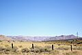
A scenic view of the Feather River Route towards Beckwourth Pass.
-
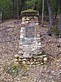
The historical marker for Elizabethtown, a former mining town.
