
North Fork Feather River facts for kids
Quick facts for kids North Fork Feather River |
|
|---|---|

Freight train crossing the North Fork, 2017
|
|

Map of the Feather River drainage basin. The North Fork flows from Lassen Peak southward to Lake Oroville.
|
|
| Country | United States |
| State | California |
| Region | North Fork Feather Watershed 1,090 sq mi (2,800 km2), including the West Fork but not East Branch Watershed |
| Physical characteristics | |
| River mouth | Lake Oroville, North ArmA |
| Length | 70 mi (110 km) |
| Basin features | |
| Basin size | 2,100 sq mi (5,400 km2) |
| APrior to Oroville Dam construction, the North Fork flowed to its former mouth in the current lake's Main Basin. | |
The North Fork Feather River is a river in the northern Sierra Nevada mountains in California, United States. It flows generally south from its starting point near Lassen Peak. The river ends at Lake Oroville, a large lake created by Oroville Dam in the foothills of the Sierra Nevada. Here, it joins the main Feather River.
This river collects water from about 2,100 square miles (5,400 km2) (that's 2,100 square miles (5,400 km2)!) of the western side of the Sierra Nevada mountains. It's the biggest river that flows into the Feather River, carrying the most water.
The North Fork Feather River starts where Rice Creek and a smaller unnamed stream meet in the southern part of Lassen Volcanic National Park. The river flows east, getting more water from Warner Creek on its left side. It then passes the town of Chester and flows into Lake Almanor, a big lake created by Canyon Dam.
After leaving the dam, the river cuts south into a deep valley called a gorge. It then turns southwest and gets water from Butt Creek on its right side. The East Branch North Fork Feather River, which is the North Fork's biggest helper river, joins it from the left near Belden. At Belden, the river is dammed again at the Rock Creek Dam. It then continues south, passing through several dams that make electricity, until it reaches the northern part of Lake Oroville.
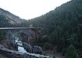
The part of the North Fork in the Feather River Canyon is famous because it's part of the Feather River Route, a railroad line. The railroad's North Fork Bridge near the river's end is the longest reinforced concrete bridge in the US.
The North Fork is very important for making hydroelectricity (power from water). It has five dams that are part of three big projects: the Upper North Fork Feather River Project, the Rock Creek-Cresta Hydroelectric Project, and the Poe Hydroelectric Project. This system is so large and powerful that people call it the "Stairway of Power."


Contents
The North Fork Feather River Watershed
The North Fork Feather Watershed is the area of land where all the rain and snow eventually drain into the North Fork Feather River. This watershed (USGS Huc 18020121) stretches from the river's source in the north all the way south to the Lower Feather Watershed.
Where the River Starts
The very beginning of the river's watershed is in the Shasta Cascades and the northern Sierra Nevada mountains. This area is near the Pit River and the Eagle-Honey watersheds. The boundary for the headwaters starts in Shasta County at a special spot called a "quadruple watershed point" near Lassen Peak. This means water from this one spot can flow into four different river systems!
The headwater boundary then curves east into Lassen County. It continues to another special spot called a "triple point" where the Feather, Pit, and Susan River watersheds meet. The boundary then arcs southeast to Pegleg Mountain and follows about 13 mi (21 km) of the Sierra Crest (the highest part of the Sierra Nevada mountains). It reaches another triple point with the East Branch North Fork Feather River on the east side of Indicator Peak.
Counties and Elevations
Most of the North Fork Feather Watershed is in Plumas County. The lowest parts of the watershed are in Butte County. Here, the emergency spillway of the Oroville Dam is at 901 ft (275 m) high. When Lake Oroville is at its average level, the water is about 812 ft (247 m) high.
Images for kids
-
A railroad trestle and CA 70 over the North Fork in the Feather River Canyon
